TopoQuest Logo
Do you find TopoQuest useful?
Help keep TopoQuest running and adding new maps/features by donating!
Bitcoin:  19c7KJd3qBynnjoSw5npx9KScwjBe4ifkT
Litecoin:  LXs6TkuXGGXo1vDsWCkWVdjQX94eUKd6ui
Home View Maps Find Maps Find Places Resources & Links


Chassahowitzka Bay, Florida Topographic Map

USGS Map Title: Chassahowitzka Bay, FL
USGS Map MRC: 28082F6
DRG (GeoTIFF) Download: o28082f6.tif


Neighboring USGS Topographic Map Quads:


  Ozello, FL  
28082G6
 

  Homosassa, FL  
28082G5


  Chassahowitzka Bay, FL  
28082F6
 

  Chassahowitzka, FL  
28082F5


  Bayport, FL  
28082E6
 

  Weeki Wachee Spring, FL  
28082E5


Map MRC Location:

N29°
W83°
N29°
W82°
H8 H7 H6 H5 H4 H3 H2 H1
G8 G7 G6 G5 G4 G3 G2 G1
F8 F7 F6 F5 F4 F3 F2 F1
E8 E7 E6 E5 E4 E3 E2 E1
D8 D7 D6 D5 D4 D3 D2 D1
C8 C7 C6 C5 C4 C3 C2 C1
B8 B7 B6 B5 B4 B3 B2 B1
A8 A7 A6 A5 A4 A3 A2 A1
N28°
W83°
N28°
W82°

Chassahowitzka Bay, FL USGS 1:24K Topographic Map Preview:
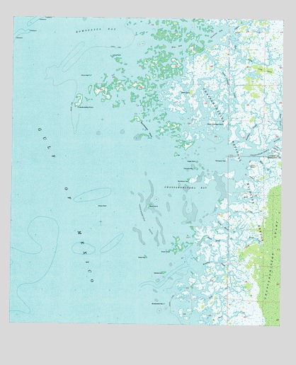
Chassahowitzka Bay, FL USGS Topographic Map
Click on map above to begin viewing in our Map Viewer.

This topographic map contains these locations and features:
Feature Name Type Latitude Longitude GNIS ID View Map
Bird IslandIslandN28.6736°W82.6859°278795View Map
Black RockIslandN28.6753°W82.7109°278939View Map
Blind CreekStreamN28.6603°W82.6448°278988View Map
Blue BayBayN28.7387°W82.6742°279008View Map
Buckhorn KeyIslandN28.6842°W82.6662°279605View Map
Camp CreekStreamN28.6855°W82.6415°279884View Map
Chassahowitzka BayBayN28.6775°W82.6654°280338View Map
Chassahowitzka National Wildlife RefugeParkN28.7163°W82.6696°280339View Map
Chassahowitzka PointCapeN28.7136°W82.7204°280340View Map
Chassahowitzka ReefsBarN28.6664°W82.6807°280341View Map
Chassahowitzka RiverStreamN28.6900°W82.6440°293961View Map
Chassahowitzka WildernessReserveN28.7142°W82.6777°2035542View Map
Chub CreekStreamN28.6725°W82.6495°280439View Map
Colvalia KeyIslandN28.6892°W82.6643°280674View Map
Crawl KeyIslandN28.6528°W82.6868°281020View Map
Custom Commerce CenterLocaleN28.6530°W82.7195°296517View Map
Drum KeyIslandN28.7267°W82.7137°281777View Map
Embassy PlazaLocaleN28.6414°W82.7273°296521View Map
Fish CreekGutN28.6389°W82.6526°282474View Map
Gator CreekBayN28.7102°W82.6268°282972View Map
Haulover CreekBayN28.6482°W82.6520°283810View Map
Homosassa BayBayN28.7419°W82.7140°284220View Map
Johns IslandIslandN28.6903°W82.6368°284853View Map
Lone Cabbage CreekStreamN28.6989°W82.6287°285936View Map
Long IslandIslandN28.7297°W82.6337°286001View Map
Long PointCapeN28.7353°W82.7043°286035View Map
May CreekStreamN28.6933°W82.6362°286537View Map
Mud CreekStreamN28.6767°W82.6468°287385View Map
North Blind CreekBayN28.6657°W82.6499°287786View Map
Northwest KeysIslandN28.7047°W82.6890°287892View Map
Oyster CreekBayN28.7462°W82.6492°288337View Map
Pompano KeyIslandN28.6930°W82.6501°289167View Map
Porpoise BayBayN28.7441°W82.6554°289222View Map
Pumpkin CreekStreamN28.6975°W82.6379°289365View Map
Rose CreekStreamN28.7444°W82.6487°289957View Map
Saddle KeyIslandN28.6464°W82.6784°290116View Map
Seven Cabbage CutoffBayN28.7228°W82.6494°290863View Map
Seven Cabbage IslandIslandN28.7083°W82.6568°290864View Map
Sheephead KeyIslandN28.6339°W82.6779°290963View Map
Slate IslandIslandN28.7203°W82.6670°291219View Map
South Blind CreekBayN28.6597°W82.6578°291346View Map
South PointIslandN28.6555°W82.6740°291410View Map
Sugar SpotIslandN28.6917°W82.6637°291777View Map
Twin CreekStreamN28.6961°W82.6312°292596View Map

Note: Coordinates in the location and feature list above are referenced to NAD83 datum.


Copyright (C) 2008-2025 Ryan Niemi / Sunset Dynamics ... All Rights Reserved