TopoQuest Logo
Do you find TopoQuest useful?
Help keep TopoQuest running and adding new maps/features by donating!
Bitcoin:  19c7KJd3qBynnjoSw5npx9KScwjBe4ifkT
Litecoin:  LXs6TkuXGGXo1vDsWCkWVdjQX94eUKd6ui
Home View Maps Find Maps Find Places Resources & Links


Chelsea, Montana Topographic Map

USGS Map Title: Chelsea, MT
USGS Map MRC: 48105B3
DRG (GeoTIFF) Download: o48105b3.tif


Neighboring USGS Topographic Map Quads:


  Sims Spring, MT  
48105C4
 

  Long Creek West, MT  
48105C3
 

  Long Creek East, MT  
48105C2
 

  Chelsea NW, MT  
48105B4
 

  Chelsea, MT  
48105B3
 

  Badger Creek, MT  
48105B2
 

  Chelsea SW, MT  
48105A4
 

  Nickwall, MT  
48105A3
 

  Poplar, MT  
48105A2


Map MRC Location:

N49°
W106°
N49°
W105°
H8 H7 H6 H5 H4 H3 H2 H1
G8 G7 G6 G5 G4 G3 G2 G1
F8 F7 F6 F5 F4 F3 F2 F1
E8 E7 E6 E5 E4 E3 E2 E1
D8 D7 D6 D5 D4 D3 D2 D1
C8 C7 C6 C5 C4 C3 C2 C1
B8 B7 B6 B5 B4 B3 B2 B1
A8 A7 A6 A5 A4 A3 A2 A1
N48°
W106°
N48°
W105°

Chelsea, MT USGS 1:24K Topographic Map Preview:
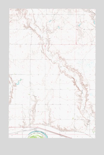
Chelsea, MT USGS Topographic Map
Click on map above to begin viewing in our Map Viewer.

This topographic map contains these locations and features:
Feature Name Type Latitude Longitude GNIS ID View Map
27N50E04AD__01 WellWellN48.1253°W105.2611°826477View Map
27N50E04BB__01 WellWellN48.1289°W105.2772°826512View Map
28N49E01DA__01 WellWellN48.2070°W105.3275°1634114View Map
28N49E10DD__01 WellWellN48.1889°W105.3703°1633976View Map
28N49E12BC__01 WellWellN48.1961°W105.3436°1634017View Map
28N49E23AD__01 WellWellN48.1670°W105.3489°1633787View Map
28N49E24BD__01 WellWellN48.1670°W105.3383°1633786View Map
28N49E36CA__01 WellWellN48.1345°W105.3383°826575View Map
28N49E36CBA_01 WellWellN48.1347°W105.3408°826577View Map
28N49E36CD__01 WellWellN48.1309°W105.3383°826533View Map
28N50E07BA__01 WellWellN48.2000°W105.3153°1634056View Map
28N50E07BA__02 WellWellN48.2000°W105.3153°1634057View Map
28N50E17DC__01 WellWellN48.1747°W105.2883°1633845View Map
28N50E21AA__01 WellWellN48.1714°W105.2617°1633813View Map
28N50E21AC__01 WellWellN48.1678°W105.2669°1633796View Map
28N50E21AD__01 WellWellN48.1678°W105.2617°1633795View Map
28N50E27CB__01 WellWellN48.1497°W105.2561°826737View Map
28N50E27CB__02 WellWellN48.1497°W105.2561°826738View Map
28N50E29DD__01 WellWellN48.1461°W105.2830°826707View Map
28N50E31BC__01 WellWellN48.1389°W105.3205°826613View Map
28N50E31DA__01 WellWellN48.1353°W105.3044°826583View Map
28N50E32CA__01 WellWellN48.1353°W105.2939°826582View Map
28N50E32DA__01 WellWellN48.1353°W105.2830°826581View Map
28N50E33DD__01 WellWellN48.1317°W105.2617°826547View Map
28N50E34CC__01 WellWellN48.1317°W105.2561°826546View Map
28N50E34CDBC01 WellWellN48.1309°W105.2522°826532View Map
Aytolloha Number 1 DamDamN48.1784°W105.3689°798307View Map
Baracker DamDamN48.2250°W105.3039°797646View Map
Boxelder CemeteryCemeteryN48.1417°W105.2608°769164View Map
Burshia School (historical)SchoolN48.1881°W105.2922°1669109View Map
ChelseaPopulated PlaceN48.1331°W105.3383°769775View Map
Chelsea (historical)LocaleN48.1331°W105.3383°1669406View Map
Chelsea SloughLakeN48.1311°W105.3303°769777View Map
Dolezilek Reservoir DamDamN48.2367°W105.3205°796305View Map
Fort Peck Reservation Number 22 DamDamN48.2350°W105.2722°798183View Map
Saint Ann's CemeteryCemeteryN48.1386°W105.2594°776097View Map
Saint Anns ChapelChurchN48.1320°W105.3003°776098View Map
Wilma DamDamN48.2367°W105.2522°798305View Map

Note: Coordinates in the location and feature list above are referenced to NAD83 datum.


Copyright (C) 2008-2024 Ryan Niemi / Sunset Dynamics ... All Rights Reserved