TopoQuest Logo
Do you find TopoQuest useful?
Help keep TopoQuest running and adding new maps/features by donating!
Bitcoin:  19c7KJd3qBynnjoSw5npx9KScwjBe4ifkT
Litecoin:  LXs6TkuXGGXo1vDsWCkWVdjQX94eUKd6ui
Home View Maps Find Maps Find Places Resources & Links


Chelsea SW, Montana Topographic Map

USGS Map Title: Chelsea SW, MT
USGS Map MRC: 48105A4
DRG (GeoTIFF) Download: o48105a4.tif


Neighboring USGS Topographic Map Quads:


  Wolf Point NE, MT  
48105B5
 

  Chelsea NW, MT  
48105B4
 

  Chelsea, MT  
48105B3
 

  Macon, MT  
48105A5
 

  Chelsea SW, MT  
48105A4
 

  Nickwall, MT  
48105A3
 

  Rock Creek, MT  
47105H5
 

  Gady Coulee, MT  
47105H4
 

  Dowse Coulee, MT  
47105H3


Map MRC Location:

N49°
W106°
N49°
W105°
H8 H7 H6 H5 H4 H3 H2 H1
G8 G7 G6 G5 G4 G3 G2 G1
F8 F7 F6 F5 F4 F3 F2 F1
E8 E7 E6 E5 E4 E3 E2 E1
D8 D7 D6 D5 D4 D3 D2 D1
C8 C7 C6 C5 C4 C3 C2 C1
B8 B7 B6 B5 B4 B3 B2 B1
A8 A7 A6 A5 A4 A3 A2 A1
N48°
W106°
N48°
W105°

Chelsea SW, MT USGS 1:24K Topographic Map Preview:
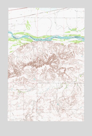
Chelsea SW, MT USGS Topographic Map
Click on map above to begin viewing in our Map Viewer.

This topographic map contains these locations and features:
Feature Name Type Latitude Longitude GNIS ID View Map
26N48E01ADBD01 WellWellN48.0367°W105.4564°825710View Map
26N48E02DBAC01 WellWellN48.0342°W105.4814°825690View Map
26N49E03BBBB01 WellWellN48.0414°W105.3875°825770View Map
26N49E09BCCA01 WellWellN48.0214°W105.4086°825583View Map
27N48E01CCCD01 WellWellN48.1145°W105.4722°826383View Map
27N48E11AD__01 WellWellN48.1100°W105.4767°826322View Map
27N48E12AC__01 WellWellN48.1100°W105.4605°826321View Map
27N48E12BB__01 WellWellN48.1136°W105.4714°826367View Map
27N48E12BB__02 WellWellN48.1136°W105.4714°826368View Map
27N48E14DD__01 WellWellN48.0884°W105.4767°826122View Map
27N48E23CD__01 WellWellN48.0742°W105.4875°826042View Map
27N48E27AD__01 WellWellN48.0670°W105.4983°825958View Map
27N49E03BD__01 WellWellN48.1239°W105.3811°826463View Map
27N49E03CA__01 WellWellN48.1203°W105.3811°826432View Map
27N49E03DB__01 WellWellN48.1203°W105.3758°826431View Map
27N49E07BB__01 WellWellN48.1131°W105.4508°826365View Map
27N49E09AA__01 WellWellN48.1131°W105.3919°826363View Map
27N49E09BA__01 WellWellN48.1131°W105.4025°826364View Map
27N49E09DA__01 WellWellN48.1059°W105.3919°826275View Map
27N49E09DB__01 WellWellN48.1059°W105.3972°826276View Map
27N49E10CB__01 WellWellN48.1059°W105.3864°826274View Map
27N49E19CCCD01 WellWellN48.0720°W105.4508°826012View Map
27N49E20CC__01 WellWellN48.0736°W105.4297°826028View Map
27N49E21AC__01 WellWellN48.0800°W105.3964°826063View Map
Chelsea School (historical)SchoolN48.1214°W105.3989°1669108View Map
Dabney (historical)LocaleN48.1203°W105.4336°1669401View Map
Nickwall DamDamN48.0517°W105.3789°795101View Map
Nickwall DamDamN48.0520°W105.3780°774630View Map
North Place DamDamN48.0200°W105.4189°797595View Map
RBW CampgroundLocaleN48.1222°W105.4906°1669260View Map

Note: Coordinates in the location and feature list above are referenced to NAD83 datum.


Copyright (C) 2008-2025 Ryan Niemi / Sunset Dynamics ... All Rights Reserved