TopoQuest Logo
Do you find TopoQuest useful?
Help keep TopoQuest running and adding new maps/features by donating!
Bitcoin:  19c7KJd3qBynnjoSw5npx9KScwjBe4ifkT
Litecoin:  LXs6TkuXGGXo1vDsWCkWVdjQX94eUKd6ui
Home View Maps Find Maps Find Places Resources & Links


Chloe, West Virginia Topographic Map

USGS Map Title: Chloe, WV
USGS Map MRC: 38081F1
DRG (GeoTIFF) Download: o38081f1.tif


Neighboring USGS Topographic Map Quads:


  Arnoldsburg, WV  
38081G2
 

  Millstone, WV  
38081G1
 

  Normantown, WV  
38080G8
 

  Tariff, WV  
38081F2
 

  Chloe, WV  
38081F1
 

  Rosedale, WV  
38080F8
 

  Newton, WV  
38081E2
 

  Ivydale, WV  
38081E1
 

  Strange Creek, WV  
38080E8


Map MRC Location:

N39°
W82°
N39°
W81°
H8 H7 H6 H5 H4 H3 H2 H1
G8 G7 G6 G5 G4 G3 G2 G1
F8 F7 F6 F5 F4 F3 F2 F1
E8 E7 E6 E5 E4 E3 E2 E1
D8 D7 D6 D5 D4 D3 D2 D1
C8 C7 C6 C5 C4 C3 C2 C1
B8 B7 B6 B5 B4 B3 B2 B1
A8 A7 A6 A5 A4 A3 A2 A1
N38°
W82°
N38°
W81°

Chloe, WV USGS 1:24K Topographic Map Preview:
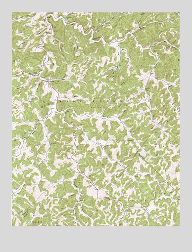
Chloe, WV USGS Topographic Map
Click on map above to begin viewing in our Map Viewer.

This topographic map contains these locations and features:
Feature Name Type Latitude Longitude GNIS ID View Map
Bailey-Siers CemeteryCemeteryN38.7120°W81.0748°1696940View Map
Bear RunStreamN38.7384°W81.0651°1535399View Map
Bear Run School (historical)SchoolN38.7437°W81.0562°1535405View Map
Beech Grove CemeteryCemeteryN38.7043°W81.0257°1696942View Map
Beech Grove ChurchChurchN38.7045°W81.0259°1535538View Map
Big White Oak RunStreamN38.6926°W81.0934°1535987View Map
Booher CemeteryCemeteryN38.7448°W81.0837°1696943View Map
Boone CemeteryCemeteryN38.7179°W81.0198°1696944View Map
Calhoun County Emergency Medical Services Station 410BuildingN38.7292°W81.1030°2581205View Map
Calhoun County Sheriff's Office - SubstationBuildingN38.7288°W81.1025°2727898View Map
Camp RunStreamN38.6432°W81.0748°1536939View Map
Chenowith-Reip CemeteryCemeteryN38.7316°W81.0448°2586283View Map
ChloePopulated PlaceN38.6926°W81.0865°1537322View Map
Chloe Post OfficePost OfficeN38.6920°W81.0859°1696947View Map
Clark Jarvis CemeteryCemeteryN38.6806°W81.1121°1696948View Map
Coen CemeteryCemeteryN38.6345°W81.0632°1537493View Map
Conley CemeteryCemeteryN38.7004°W81.1112°1696949View Map
Cooper CemeteryCemeteryN38.6915°W81.0932°1696950View Map
Cottrill CemeteryCemeteryN38.6470°W81.1229°1537704View Map
Crooked RunStreamN38.7448°W81.0865°1537855View Map
Dawson ForkStreamN38.6340°W81.0415°1538075View Map
District 5CivilN38.7027°W81.0833°1928242View Map
DouglasPopulated PlaceN38.6723°W81.0579°1549659View Map
Downey CemeteryCemeteryN38.7334°W81.0095°1696952View Map
Ebenezer Baptist ChurchChurchN38.7343°W81.0648°1538530View Map
Ebenezer CemeteryCemeteryN38.7343°W81.0651°1696953View Map
EuclidPopulated PlaceN38.7331°W81.0446°1549675View Map
Fairview CemeteryCemeteryN38.7168°W81.0493°1696956View Map
Fairview ChurchChurchN38.7176°W81.0465°1538809View Map
FloePopulated PlaceN38.6440°W81.0123°1554478View Map
Frozen RunStreamN38.7370°W81.0357°1539285View Map
Gomez (historical)Populated PlaceN38.7423°W81.0754°1696957View Map
Goodrich CemeteryCemeteryN38.7084°W81.0084°1696959View Map
Greathouse CemeteryCemeteryN38.7456°W81.1232°1696960View Map
Hardway RunStreamN38.7131°W81.1043°1539950View Map
Hawkins CemeteryCemeteryN38.6571°W81.1214°2586186View Map
Hicks CemeteryCemeteryN38.6659°W81.0771°1696961View Map
Hicks CemeteryCemeteryN38.6637°W81.1015°1696962View Map
King CemeteryCemeteryN38.7014°W81.0404°2574004View Map
Lamb CemeteryCemeteryN38.6718°W81.0568°1696964View Map
Left Fork West Fork Little Kanawha RiverStreamN38.7479°W81.0990°1541742View Map
Little White Oak ChurchChurchN38.6729°W81.0968°1542255View Map
Losie (historical)Populated PlaceN38.6782°W81.0359°1696966View Map
Lower Nicut RunStreamN38.7318°W81.0482°1542558View Map
LydiaPopulated PlaceN38.6545°W81.0343°1555012View Map
Matheny CemeteryCemeteryN38.6537°W81.0479°1542863View Map
McCune CemeteryCemeteryN38.6856°W81.0815°1696968View Map
Meadow RunStreamN38.7115°W81.1029°1543072View Map
MinnoraPopulated PlaceN38.7095°W81.0982°1555137View Map
Minnora CemeteryCemeteryN38.7195°W81.1001°1543445View Map
Minnora Post OfficePost OfficeN38.7093°W81.0984°1696970View Map
Minnora School (historical)SchoolN38.7137°W81.1071°1543446View Map
Mollohan CemeteryCemeteryN38.7026°W81.0868°1696971View Map
Mollohan/Cooper CemeteryCemeteryN38.6326°W81.0429°2586225View Map
Morris CemeteryCemeteryN38.6559°W81.0665°1696972View Map
Moss CemeteryCemeteryN38.6640°W81.0509°1696973View Map
Mount RunStreamN38.7059°W81.0093°1543755View Map
MudforkPopulated PlaceN38.6393°W81.0751°1549841View Map
Mudfork RunStreamN38.6387°W81.0746°1543932View Map
Mule KnobSummitN38.6998°W81.0629°1543985View Map
NeboPopulated PlaceN38.6345°W81.0426°1549845View Map
Nebo Baptist ChurchChurchN38.6354°W81.0251°1539944View Map
Nebo Post OfficePost OfficeN38.6348°W81.0423°1741338View Map
Nebo-Hallsburg HollowValleyN38.6337°W81.0246°1741337View Map
NicutPopulated PlaceN38.7131°W81.0221°1549852View Map
Nicut Post OfficePost OfficeN38.7137°W81.0223°1696975View Map
Nicut RunStreamN38.7126°W81.0226°1544169View Map
Old Metheney Ridge Church (historical)ChurchN38.6543°W81.0479°1696977View Map
OrmaPopulated PlaceN38.7481°W81.0998°1544444View Map
Orma CemeteryCemeteryN38.7487°W81.0987°1696978View Map
Owl RunStreamN38.7026°W81.0926°1544495View Map
Pond RunStreamN38.6523°W81.0796°1545133View Map
Prudence ChapelChurchN38.7098°W81.0987°1545303View Map
Sears CemeteryCemeteryN38.6406°W81.0168°1546537View Map
Sears RunStreamN38.7112°W81.1007°1546538View Map
Spruce RunStreamN38.7404°W81.0304°1547275View Map
StinsonPopulated PlaceN38.6565°W81.0746°1555714View Map
Stinson CreekStreamN38.6565°W81.0748°1547428View Map
Straight RunStreamN38.7368°W81.0957°1547570View Map
Upper Big RunStreamN38.7293°W81.0223°1548505View Map
Upper West Fork Volunteer Fire DepartmentBuildingN38.6987°W81.0931°2577712View Map
Walker CreekStreamN38.6823°W81.0754°1548724View Map
Walker School (historical)SchoolN38.6551°W81.0223°1548731View Map
WalnutPopulated PlaceN38.6890°W81.0576°1549976View Map
Walnut CemeteryCemeteryN38.6893°W81.0546°1696983View Map
Walnut ForkStreamN38.6920°W81.0871°1548750View Map
Walnut Methodist ChurchChurchN38.6890°W81.0543°1696984View Map
White Oak ChurchChurchN38.6862°W81.1046°1549046View Map
White Oak RunStreamN38.6862°W81.1018°1549063View Map
Wolf RunStreamN38.7423°W81.0965°1549295View Map

Note: Coordinates in the location and feature list above are referenced to NAD83 datum.


Copyright (C) 2008-2025 Ryan Niemi / Sunset Dynamics ... All Rights Reserved