TopoQuest Logo
Do you find TopoQuest useful?
Help keep TopoQuest running and adding new maps/features by donating!
Bitcoin:  19c7KJd3qBynnjoSw5npx9KScwjBe4ifkT
Litecoin:  LXs6TkuXGGXo1vDsWCkWVdjQX94eUKd6ui
Home View Maps Find Maps Find Places Resources & Links


Strange Creek, West Virginia Topographic Map

USGS Map Title: Strange Creek, WV
USGS Map MRC: 38080E8
DRG (GeoTIFF) Download: o38080e8.tif


Neighboring USGS Topographic Map Quads:


  Chloe, WV  
38081F1
 

  Rosedale, WV  
38080F8
 

  Gassaway, WV  
38080F7
 

  Ivydale, WV  
38081E1
 

  Strange Creek, WV  
38080E8
 

  Herold, WV  
38080E7
 

  Clay, WV  
38081D1
 

  Swandale, WV  
38080D8
 

  Widen, WV  
38080D7


Map MRC Location:

N39°
W81°
N39°
W80°
H8 H7 H6 H5 H4 H3 H2 H1
G8 G7 G6 G5 G4 G3 G2 G1
F8 F7 F6 F5 F4 F3 F2 F1
E8 E7 E6 E5 E4 E3 E2 E1
D8 D7 D6 D5 D4 D3 D2 D1
C8 C7 C6 C5 C4 C3 C2 C1
B8 B7 B6 B5 B4 B3 B2 B1
A8 A7 A6 A5 A4 A3 A2 A1
N38°
W81°
N38°
W80°

Strange Creek, WV USGS 1:24K Topographic Map Preview:
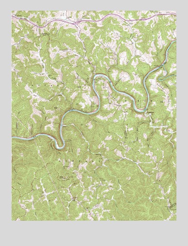
Strange Creek, WV USGS Topographic Map
Click on map above to begin viewing in our Map Viewer.

This topographic map contains these locations and features:
Feature Name Type Latitude Longitude GNIS ID View Map
Big ForkStreamN38.5526°W80.8782°1535844View Map
Birch Lake (historical)ReservoirN38.6062°W80.8776°1560639View Map
Birch RiverStreamN38.5923°W80.8845°1550362View Map
Bragg KnobSummitN38.5254°W80.9634°1536296View Map
Canoe RunStreamN38.5926°W80.8857°1537008View Map
Chapman CemeteryCemeteryN38.5240°W80.9284°1537204View Map
Coon HollowValleyN38.5804°W80.9223°1537633View Map
David Hamrick Memorial CemeteryCemeteryN38.6183°W80.9125°2724764View Map
Davis RunStreamN38.5832°W80.8859°1538053View Map
DuckPopulated PlaceN38.5834°W80.9368°1538393View Map
Duck CreekStreamN38.5868°W80.9359°1538397View Map
Duck Post OfficePost OfficeN38.5922°W80.9370°1741289View Map
Duffield CemeteryCemeteryN38.5706°W80.9370°1538410View Map
Eagle CemeteryCemeteryN38.5848°W80.9484°1538488View Map
Flat Fork Missionary Baptist ChurchChurchN38.5084°W80.9370°1539048View Map
Flat Fork School (historical)SchoolN38.5070°W80.9434°1539050View Map
Frame KnobSummitN38.5665°W80.9687°1539219View Map
Frame Knob (historical)Populated PlaceN38.5698°W80.9545°1741297View Map
Frame RunStreamN38.5637°W80.9429°1539220View Map
GlendonPopulated PlaceN38.5912°W80.8887°1554572View Map
Glendon Post Office (historical)Post OfficeN38.5912°W80.8887°1727330View Map
Goad CemeteryCemeteryN38.5584°W80.8934°1539481View Map
GrovesPopulated PlaceN38.5562°W80.9618°1554619View Map
Groves CreekStreamN38.5568°W80.9615°1539772View Map
Groves Creek ChurchChurchN38.5390°W80.9315°1539773View Map
Hall CemeteryCemeteryN38.6151°W80.9471°2574001View Map
HallburgPopulated PlaceN38.6220°W80.9971°1549725View Map
Hallburg CemeteryCemeteryN38.6212°W80.9873°1741303View Map
Hallsburg Baptist ChurchChurchN38.6218°W80.9965°1741306View Map
HarrisonPopulated PlaceN38.5129°W80.9534°1549730View Map
Harrison Post OfficePost OfficeN38.5048°W80.9398°1741307View Map
Hog ForkStreamN38.6076°W80.9095°1540345View Map
Hyer ChapelChurchN38.5845°W80.9679°1540644View Map
Interchange 46CrossingN38.6173°W80.9512°1727343View Map
IraPopulated PlaceN38.5629°W80.9607°1741312View Map
Jumping Gut RunStreamN38.5493°W80.9687°1541046View Map
Keeners Ridge Community ChurchChurchN38.5632°W80.8948°1727349View Map
Laurel ForkStreamN38.5332°W80.9307°1541439View Map
Laurel ForkStreamN38.5920°W80.9201°1541442View Map
Laurel ForkStreamN38.5973°W80.9448°1541443View Map
Logshoal RunStreamN38.5495°W80.9957°1542320View Map
Long KnobSummitN38.5707°W80.8845°1542385View Map
Lower Mill RunStreamN38.5579°W80.8951°1542556View Map
Lyons CemeteryCemeteryN38.5645°W80.9143°1542658View Map
McCracken CemeteryCemeteryN38.5776°W80.9831°2586286View Map
Murphy CemeteryCemeteryN38.5868°W80.9045°1544010View Map
Nelson ForkStreamN38.5493°W80.9848°1544093View Map
O'BrionPopulated PlaceN38.5754°W80.9618°1549856View Map
O'Brion ChurchChurchN38.5859°W80.9718°1544271View Map
O'Brion CreekStreamN38.5662°W80.9537°1544268View Map
Paddy CreekStreamN38.5465°W80.9604°1544515View Map
Plum RunStreamN38.5365°W80.9279°1545062View Map
Point CemeteryCemeteryN38.6190°W80.9509°1545089View Map
Point Lick BranchStreamN38.5876°W80.9746°1545092View Map
Right Fork Big ForkStreamN38.5443°W80.8770°1545610View Map
Road ForkStreamN38.5754°W80.9618°1545812View Map
Root ForkStreamN38.5190°W80.9179°1546062View Map
ServiaPopulated PlaceN38.6204°W80.9573°1546579View Map
Servia Volunteer Fire DepartmentBuildingN38.6126°W80.9478°2577849View Map
Snake ForkStreamN38.5804°W80.9379°1547020View Map
Snake KnobSummitN38.5793°W80.9501°1555652View Map
Strange CreekPopulated PlaceN38.5632°W80.8979°1555727View Map
Strange CreekStreamN38.5662°W80.8976°1547580View Map
Strange Creek CemeteryCemeteryN38.5631°W80.8943°1727376View Map
Strange Creek Post OfficePost OfficeN38.5634°W80.8982°1727377View Map
Strange Creek United Methodist Church (historical)ChurchN38.5632°W80.8948°1727378View Map
TatePopulated PlaceN38.6159°W80.9109°1549953View Map
Tate CreekStreamN38.5851°W80.9276°1547914View Map
Turner CemeteryCemeteryN38.5201°W80.9259°1548379View Map
Twisting Chute CreekStreamN38.5512°W80.9784°1548406View Map
Upper Mill RunStreamN38.5559°W80.8912°1548537View Map
Valley ChapelChurchN38.5123°W80.9540°1548585View Map
Villanova RidgeRidgeN38.5659°W80.9173°1548668View Map
Wilson RidgeRidgeN38.5037°W80.8782°1549229View Map

Note: Coordinates in the location and feature list above are referenced to NAD83 datum.


Copyright (C) 2008-2024 Ryan Niemi / Sunset Dynamics ... All Rights Reserved