TopoQuest Logo
Do you find TopoQuest useful?
Help keep TopoQuest running and adding new maps/features by donating!
Bitcoin:  19c7KJd3qBynnjoSw5npx9KScwjBe4ifkT
Litecoin:  LXs6TkuXGGXo1vDsWCkWVdjQX94eUKd6ui
Home View Maps Find Maps Find Places Resources & Links


Citronelle East, Alabama Topographic Map

USGS Map Title: Citronelle East, AL
USGS Map MRC: 31088A2
DRG (GeoTIFF) Download: o31088a2.tif


Neighboring USGS Topographic Map Quads:


  Deer Park, AL  
31088B3
 

  Sims Chapel, AL  
31088B2
 

  Calvert, AL  
31088B1
 

  Citronelle West, AL  
31088A3
 

  Citronelle East, AL  
31088A2
 

  Mount Vernon, AL  
31088A1
 

  Georgetown, AL  
30088H3
 

  Chunchula, AL  
30088H2
 

  Creola, AL  
30088H1


Map MRC Location:

N32°
W89°
N32°
W88°
H8 H7 H6 H5 H4 H3 H2 H1
G8 G7 G6 G5 G4 G3 G2 G1
F8 F7 F6 F5 F4 F3 F2 F1
E8 E7 E6 E5 E4 E3 E2 E1
D8 D7 D6 D5 D4 D3 D2 D1
C8 C7 C6 C5 C4 C3 C2 C1
B8 B7 B6 B5 B4 B3 B2 B1
A8 A7 A6 A5 A4 A3 A2 A1
N31°
W89°
N31°
W88°

Citronelle East, AL USGS 1:24K Topographic Map Preview:
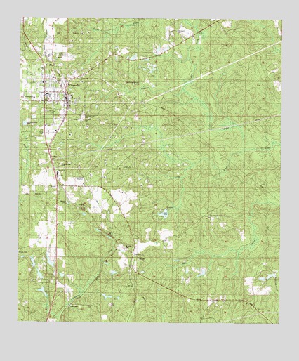
Citronelle East, AL USGS Topographic Map
Click on map above to begin viewing in our Map Viewer.

This topographic map contains these locations and features:
Feature Name Type Latitude Longitude GNIS ID View Map
Apostolic Faith ChurchChurchN31.0978°W88.2306°2580408View Map
Bethlehem ChurchChurchN31.0618°W88.2317°143153View Map
Butler Church of ChristChurchN31.0891°W88.2050°139962View Map
Camp PushmatahaLocaleN31.0752°W88.2308°143186View Map
Cedar Creek ChurchChurchN31.0813°W88.1258°115760View Map
Cedar Creek Church of the BrethrenChurchN31.1164°W88.1803°143168View Map
Cedar Creek State ParkParkN31.0488°W88.1847°115767View Map
Celeste Road ChurchChurchN31.0288°W88.1953°143203View Map
Charity Chapel Volunteer Fire DepartmentBuildingN31.0905°W88.2385°2330987View Map
Cherokee Mineral SpringsSpringN31.0990°W88.1928°116004View Map
Church of God of CitronelleChurchN31.1021°W88.2198°2579293View Map
CitronellePopulated PlaceN31.0907°W88.2281°116155View Map
Citronelle Area Chamber of CommerceBuildingN31.0905°W88.2367°2579609View Map
Citronelle BranchStreamN31.0966°W88.1711°116156View Map
Citronelle City Fire DepartmentBuildingN31.0900°W88.2279°2330967View Map
Citronelle City HallBuildingN31.0899°W88.2281°2579607View Map
Citronelle Faith TabernacleChurchN31.1076°W88.2342°2579291View Map
Citronelle Fire Department Station 1BuildingN31.0901°W88.2291°2330973View Map
Citronelle High SchoolSchoolN31.0931°W88.2356°143246View Map
Citronelle Memorial LibraryBuildingN31.0907°W88.2290°2579919View Map
Citronelle Methodist Church CemeteryCemeteryN31.0959°W88.2316°2579296View Map
Citronelle Police DepartmentBuildingN31.0900°W88.2280°2751821View Map
Citronelle Post OfficePost OfficeN31.1033°W88.2364°2578964View Map
Citronelle Senior CenterBuildingN31.0907°W88.2290°2579608View Map
Citronelle United Methodist ChurchChurchN31.0951°W88.2317°2579297View Map
City of CitronelleCivilN31.0952°W88.2467°2404051View Map
Echo LakeReservoirN31.0418°W88.1833°129621View Map
Echo Lake DamDamN31.0418°W88.1833°129622View Map
First Baptist Church of CitronelleChurchN31.0917°W88.2450°2580411View Map
First Presbyterian Church of CitronelleChurchN31.0911°W88.2284°2579295View Map
Frazier CemeteryCemeteryN31.1194°W88.1523°2579299View Map
H G Quinnelly DamDamN31.0235°W88.2333°129611View Map
H G Quinnelly LakeReservoirN31.0251°W88.2349°129610View Map
Howard E Smith DamDamN31.0202°W88.2300°129607View Map
Howard E Smith LakeReservoirN31.0195°W88.2290°129606View Map
LambertPopulated PlaceN31.0280°W88.1933°143474View Map
Lambert CemeteryCemeteryN31.0332°W88.1925°121356View Map
Lambert CemeteryCemeteryN31.0335°W88.1922°1729995View Map
Lambert GrovePopulated PlaceN31.0435°W88.1572°143475View Map
Lambert Grove ChurchChurchN31.0435°W88.1589°143476View Map
Lambert Grove ChurchChurchN31.0338°W88.1925°143477View Map
Langdon (historical)LocaleN31.0474°W88.2111°149613View Map
Langdon ChurchChurchN31.0502°W88.2114°121383View Map
Langdon Lookout TowerTowerN31.0480°W88.2214°143480View Map
Little CreekStreamN31.0710°W88.1383°121749View Map
Living Word ChurchChurchN31.1151°W88.2448°2580409View Map
Meinhardt CemeteryCemeteryN31.1199°W88.1747°143526View Map
Memorial Baptist ChurchChurchN31.1006°W88.2340°2579290View Map
Mobile County Emergency Medical Services - CitronelleBuildingN31.0912°W88.2308°2330969View Map
Mobile County Health Department Citronelle ClinicBuildingN31.0928°W88.2286°2579871View Map
Mobile County Health Department Citronelle Clinic AnnexBuildingN31.0935°W88.2281°2579872View Map
Mount Nebo CemeteryCemeteryN31.0830°W88.2197°143572View Map
Nazarene African Methodist Episcopal Zion ChurchChurchN31.0976°W88.2270°2580410View Map
Pilgrims Rest CemeteryCemeteryN31.0649°W88.2303°143654View Map
Pine Crest CemeteryCemeteryN31.0843°W88.2197°143656View Map
Pratt Turner DamDamN31.0185°W88.1300°129601View Map
Rolling Hills Youth CampLocaleN31.0302°W88.2458°143699View Map
Rosa A Lott Elementary SchoolSchoolN31.0605°W88.2314°165625View Map
RussellPopulated PlaceN31.0563°W88.2320°1989118View Map
Saint Annes CemeteryCemeteryN31.0310°W88.1986°143705View Map
Saint Annes ChurchChurchN31.0310°W88.1992°126081View Map
Saint Johns Catholic ChurchChurchN31.0927°W88.2353°140114View Map
Saint Thomas Aquinas Catholic ChurchChurchN31.0906°W88.2335°2579298View Map
Scoutshire Girl Scout CampLocaleN31.0391°W88.1875°143785View Map
Scoutshire WoodsPopulated PlaceN31.0468°W88.1817°143786View Map
Shiloh Baptist ChurchChurchN31.0976°W88.2269°2579294View Map
SidneyPopulated PlaceN31.0680°W88.2345°143805View Map
South Alabama Utilities Citronelle LagoonLocaleN31.0840°W88.2476°2579664View Map
Spring LakeReservoirN31.0492°W88.2267°127264View Map
Vienna Ferry (historical)CrossingN31.0168°W88.1936°135641View Map
West Calvert ChurchChurchN31.1180°W88.1675°153936View Map

Note: Coordinates in the location and feature list above are referenced to NAD83 datum.


Copyright (C) 2008-2024 Ryan Niemi / Sunset Dynamics ... All Rights Reserved