TopoQuest Logo
Do you find TopoQuest useful?
Help keep TopoQuest running and adding new maps/features by donating!
Bitcoin:  19c7KJd3qBynnjoSw5npx9KScwjBe4ifkT
Litecoin:  LXs6TkuXGGXo1vDsWCkWVdjQX94eUKd6ui
Home View Maps Find Maps Find Places Resources & Links


Chunchula, Alabama Topographic Map

USGS Map Title: Chunchula, AL
USGS Map MRC: 30088H2
DRG (GeoTIFF) Download: o30088h2.tif


Neighboring USGS Topographic Map Quads:


  Citronelle West, AL  
31088A3
 

  Citronelle East, AL  
31088A2
 

  Mount Vernon, AL  
31088A1
 

  Georgetown, AL  
30088H3
 

  Chunchula, AL  
30088H2
 

  Creola, AL  
30088H1
 

  Semmes, AL  
30088G3
 

  Kushla, AL  
30088G2
 

  Chickasaw, AL  
30088G1


Map MRC Location:

N31°
W89°
N31°
W88°
H8 H7 H6 H5 H4 H3 H2 H1
G8 G7 G6 G5 G4 G3 G2 G1
F8 F7 F6 F5 F4 F3 F2 F1
E8 E7 E6 E5 E4 E3 E2 E1
D8 D7 D6 D5 D4 D3 D2 D1
C8 C7 C6 C5 C4 C3 C2 C1
B8 B7 B6 B5 B4 B3 B2 B1
A8 A7 A6 A5 A4 A3 A2 A1
N30°
W89°
N30°
W88°

Chunchula, AL USGS 1:24K Topographic Map Preview:
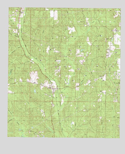
Chunchula, AL USGS Topographic Map
Click on map above to begin viewing in our Map Viewer.

This topographic map contains these locations and features:
Feature Name Type Latitude Longitude GNIS ID View Map
Arden ChurchChurchN30.8799°W88.2192°1729948View Map
Beaver Meadow (historical)LocaleN30.9696°W88.2347°149608View Map
Beaver Pond CreekStreamN30.9496°W88.2228°113748View Map
Calvary ChurchChurchN30.9577°W88.1378°143179View Map
ChunchulaPopulated PlaceN30.9219°W88.2006°116112View Map
Chunchula Census Designated PlaceCensusN30.9237°W88.2072°2628585View Map
Chunchula Gas FieldOilfieldN30.9294°W88.1458°163315View Map
Chunchula Post OfficePost OfficeN30.9223°W88.1991°2578963View Map
Dogwood ParkParkN30.9705°W88.1417°143299View Map
Drinking BranchStreamN30.9718°W88.2364°117474View Map
Dubois Lake DamDamN30.9685°W88.1333°129594View Map
Duboise LakeReservoirN30.9699°W88.1345°129593View Map
East Chunchula SchoolSchoolN30.9805°W88.1522°117745View Map
Fellowship Baptist ChurchChurchN30.9960°W88.2406°2579288View Map
Fred Hildesheim DamDamN30.8752°W88.2050°129586View Map
God ChurchChurchN30.9244°W88.2097°1729978View Map
Gulf Crest CemeteryCemeteryN30.9966°W88.2397°1729981View Map
Gulf Crest ChurchChurchN30.9955°W88.2403°119461View Map
Gulf Crest ChurchChurchN30.9960°W88.2406°1729982View Map
GulfcrestPopulated PlaceN30.9955°W88.2375°143406View Map
Gulfcrest Census Designated PlaceCensusN30.9925°W88.2399°2628592View Map
Larkin Spring BranchStreamN30.9391°W88.2453°121398View Map
Lewis Williams BranchStreamN30.8944°W88.2445°121526View Map
Log CreekStreamN30.9169°W88.1950°121961View Map
Long BranchStreamN30.9418°W88.2117°121981View Map
Maddox Mobile Home ParkPopulated PlaceN30.9355°W88.1423°2579777View Map
Mickers CreekStreamN30.8860°W88.1750°143531View Map
Miller Spring BranchStreamN30.8944°W88.2442°122835View Map
Oak Grove SchoolSchoolN30.9752°W88.1333°152743View Map
Orvin Lookout TowerTowerN30.9282°W88.1253°143624View Map
Sand Hill CreekStreamN30.9763°W88.2367°126312View Map
Starlight Full Gospel ChurchChurchN30.9241°W88.2098°143840View Map
Starlight SchoolSchoolN30.9241°W88.2125°127318View Map
Sweetwater BranchStreamN30.9596°W88.2325°153627View Map
TurnervillePopulated PlaceN30.9785°W88.1292°143892View Map
Turnerville CemeteryCemeteryN30.9799°W88.1311°1730042View Map
Turnerville ChurchChurchN30.9793°W88.1311°128201View Map
Turnerville ChurchChurchN30.9607°W88.1372°143893View Map
Turnerville Volunteer Fire Department Station 1BuildingN30.9989°W88.1256°2691187View Map
Turnerville Volunteer Fire Department Station 2BuildingN30.9251°W88.1260°2691174View Map

Note: Coordinates in the location and feature list above are referenced to NAD83 datum.


Copyright (C) 2008-2024 Ryan Niemi / Sunset Dynamics ... All Rights Reserved