TopoQuest Logo
Do you find TopoQuest useful?
Help keep TopoQuest running and adding new maps/features by donating!
Bitcoin:  19c7KJd3qBynnjoSw5npx9KScwjBe4ifkT
Litecoin:  LXs6TkuXGGXo1vDsWCkWVdjQX94eUKd6ui
Home View Maps Find Maps Find Places Resources & Links


Clark, Louisiana Topographic Map

USGS Map Title: Clark, LA
USGS Map MRC: 32092A2
DRG (GeoTIFF) Download: o32092a2.tif


Neighboring USGS Topographic Map Quads:


  Vixen, LA  
32092B3
 

  Blankston, LA  
32092B2
 

  Riverton, LA  
32092B1
 

  Cotton Plant, LA  
32092A3
 

  Clark, LA  
32092A2
 

  Columbia, LA  
32092A1
 

  Olla West, LA  
31092H3
 

  Olla East, LA  
31092H2
 

  Holum, LA  
31092H1


Map MRC Location:

N33°
W93°
N33°
W92°
H8 H7 H6 H5 H4 H3 H2 H1
G8 G7 G6 G5 G4 G3 G2 G1
F8 F7 F6 F5 F4 F3 F2 F1
E8 E7 E6 E5 E4 E3 E2 E1
D8 D7 D6 D5 D4 D3 D2 D1
C8 C7 C6 C5 C4 C3 C2 C1
B8 B7 B6 B5 B4 B3 B2 B1
A8 A7 A6 A5 A4 A3 A2 A1
N32°
W93°
N32°
W92°

Clark, LA USGS 1:24K Topographic Map Preview:
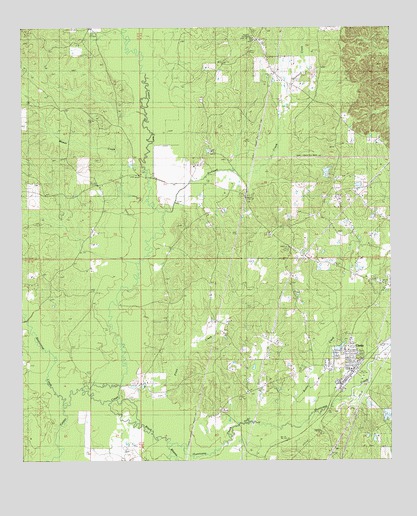
Clark, LA USGS Topographic Map
Click on map above to begin viewing in our Map Viewer.

This topographic map contains these locations and features:
Feature Name Type Latitude Longitude GNIS ID View Map
Banks Springs Gas FieldOilfieldN32.0877°W92.1326°542379View Map
Beaucoup CreekStreamN32.0165°W92.2365°553552View Map
Bethel Church Gas FieldOilfieldN32.0874°W92.2024°542381View Map
Black BayouStreamN32.0168°W92.2118°553671View Map
Bushy CreekStreamN32.0118°W92.1587°533580View Map
Caldwell Parish Detention CenterBuildingN32.0366°W92.1377°2755253View Map
ClarksPopulated PlaceN32.0265°W92.1390°554002View Map
Clarks Post OfficePost OfficeN32.0265°W92.1393°1630053View Map
Clarks Volunteer Fire DepartmentBuildingN32.0270°W92.1389°2672765View Map
Cooper (historical)Populated PlaceN32.0649°W92.2165°546292View Map
Cross Roads Baptist ChurchChurchN32.0657°W92.1662°554141View Map
Cross Roads CemeteryCemeteryN32.0654°W92.1660°542392View Map
East Columbia Volunteer Fire DepartmentBuildingN32.0971°W92.1294°2673039View Map
Hurricane CreekStreamN32.0038°W92.1962°554811View Map
KARD-TV (West Monroe)TowerN32.0949°W92.1776°1632506View Map
Kelly School Gas FieldOilfieldN32.0099°W92.2176°542406View Map
Messer CreekStreamN32.0743°W92.2074°537042View Map
Mount Pleasant Lookout TowerTowerN32.1229°W92.1715°558806View Map
New Bethel CemeteryCemeteryN32.0346°W92.1415°542413View Map
North Clarks Gas FieldOilfieldN32.0502°W92.1529°542414View Map
Oak Grove School (historical)SchoolN32.0354°W92.1862°546333View Map
Old Bethel Baptist ChurchChurchN32.0146°W92.1821°555538View Map
Old Bethel CemeteryCemeteryN32.0146°W92.1812°542417View Map
Old Bethel Christian Academy SchoolSchoolN32.0146°W92.1833°2462945View Map
Parish Governing Authority District 3CivilN32.1185°W92.2321°1929942View Map
Parish Governing Authority District 6CivilN32.0059°W92.2348°1930125View Map
Piney CreekStreamN32.0177°W92.2182°538201View Map
Richland CreekStreamN32.0721°W92.2026°538594View Map
Village of ClarksCivilN32.0288°W92.1408°2407433View Map
Ward NineCivilN32.0304°W92.1401°544965View Map
Ward SevenCivilN32.0602°W92.1321°544963View Map
Ward TwoCivilN32.1018°W92.2382°544958View Map
West Clarks Gas FieldOilfieldN32.0365°W92.1696°542429View Map

Note: Coordinates in the location and feature list above are referenced to NAD83 datum.


Copyright (C) 2008-2025 Ryan Niemi / Sunset Dynamics ... All Rights Reserved