TopoQuest Logo
Do you find TopoQuest useful?
Help keep TopoQuest running and adding new maps/features by donating!
Bitcoin:  19c7KJd3qBynnjoSw5npx9KScwjBe4ifkT
Litecoin:  LXs6TkuXGGXo1vDsWCkWVdjQX94eUKd6ui
Home View Maps Find Maps Find Places Resources & Links


Clark, Mississippi Topographic Map

USGS Map Title: Clark, MS
USGS Map MRC: 31088C5
DRG (GeoTIFF) Download: o31088c5.tif


Neighboring USGS Topographic Map Quads:


  Piave, MS  
31088D6
 

  Knobtown, MS  
31088D5
 

  State Line, MS  
31088D4
 

  Avera, MS  
31088C6
 

  Clark, MS  
31088C5
 

  Fruitdale, AL  
31088C4
 

  Jonathan, MS  
31088B6
 

  Leakesville, MS  
31088B5
 

  Rounsaville, MS  
31088B4


Map MRC Location:

N32°
W89°
N32°
W88°
H8 H7 H6 H5 H4 H3 H2 H1
G8 G7 G6 G5 G4 G3 G2 G1
F8 F7 F6 F5 F4 F3 F2 F1
E8 E7 E6 E5 E4 E3 E2 E1
D8 D7 D6 D5 D4 D3 D2 D1
C8 C7 C6 C5 C4 C3 C2 C1
B8 B7 B6 B5 B4 B3 B2 B1
A8 A7 A6 A5 A4 A3 A2 A1
N31°
W89°
N31°
W88°

Clark, MS USGS 1:24K Topographic Map Preview:
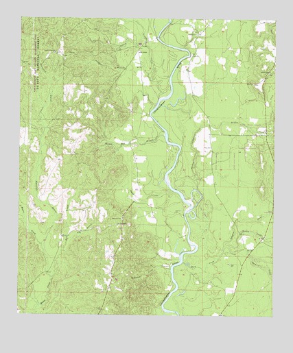
Clark, MS USGS Topographic Map
Click on map above to begin viewing in our Map Viewer.

This topographic map contains these locations and features:
Feature Name Type Latitude Longitude GNIS ID View Map
Adamsville (historical)Populated PlaceN31.2932°W88.5459°707705View Map
Adamsville CemeteryCemeteryN31.2932°W88.5481°692376View Map
Avera CemeteryCemeteryN31.3599°W88.5409°692433View Map
Big BranchStreamN31.3671°W88.5647°692591View Map
Brannon CreekStreamN31.2793°W88.5242°692692View Map
Byrd CreekStreamN31.2730°W88.5445°692792View Map
Church of ChristChurchN31.3613°W88.6084°692905View Map
ClarkPopulated PlaceN31.2882°W88.5739°692914View Map
Fellowship CemeteryCemeteryN31.2907°W88.5745°693204View Map
Fellowship Freewill Baptist ChurchChurchN31.2899°W88.5734°705228View Map
Flat BranchStreamN31.2818°W88.6009°693222View Map
Freefield CemeteryCemeteryN31.3602°W88.6086°693265View Map
Griffin CemeteryCemeteryN31.3479°W88.5103°693370View Map
Griffin CreekStreamN31.3030°W88.5375°693372View Map
Griffin CreekStreamN31.3413°W88.5570°693373View Map
Huff BranchStreamN31.2657°W88.6081°693556View Map
Johnson CreekStreamN31.3296°W88.5122°693628View Map
Johnson Creek Baptist ChurchChurchN31.3527°W88.5028°693629View Map
Johnson Creek CemeteryCemeteryN31.3521°W88.5031°707711View Map
McKinnis CreekStreamN31.2696°W88.5500°693925View Map
Morgan Mill BranchStreamN31.3255°W88.5536°694036View Map
Odom CemeteryCemeteryN31.3210°W88.5311°694248View Map
Old AveraPopulated PlaceN31.3610°W88.5670°694255View Map
Painters BranchStreamN31.3288°W88.6134°705239View Map
Panther BranchStreamN31.3518°W88.5620°694302View Map
Platt CemeteryCemeteryN31.2718°W88.5214°694417View Map
Robertson CreekStreamN31.3391°W88.5567°705241View Map
Simpson CemeteryCemeteryN31.3685°W88.5386°694797View Map
Smith CreekStreamN31.3027°W88.5497°694825View Map
Supervisor District 2CivilN31.3333°W88.5450°711859View Map
Turkey CreekStreamN31.2793°W88.5220°695018View Map
Waterfork BranchStreamN31.2799°W88.6139°695102View Map

Note: Coordinates in the location and feature list above are referenced to NAD83 datum.


Copyright (C) 2008-2025 Ryan Niemi / Sunset Dynamics ... All Rights Reserved