TopoQuest Logo
Do you find TopoQuest useful?
Help keep TopoQuest running and adding new maps/features by donating!
Bitcoin:  19c7KJd3qBynnjoSw5npx9KScwjBe4ifkT
Litecoin:  LXs6TkuXGGXo1vDsWCkWVdjQX94eUKd6ui
Home View Maps Find Maps Find Places Resources & Links


Clarkson, Kentucky Topographic Map

USGS Map Title: Clarkson, KY
USGS Map MRC: 37086D2
DRG (GeoTIFF) Download: o37086d2.tif


Neighboring USGS Topographic Map Quads:


  Madrid, KY  
37086E3
 

  Big Clifty, KY  
37086E2
 

  Summit, KY  
37086E1
 

  Leitchfield, KY  
37086D3
 

  Clarkson, KY  
37086D2
 

  Millerstown, KY  
37086D1
 

  Bee Spring, KY  
37086C3
 

  Nolin Lake, KY  
37086C2
 

  Cub Run, KY  
37086C1


Map MRC Location:

N38°
W87°
N38°
W86°
H8 H7 H6 H5 H4 H3 H2 H1
G8 G7 G6 G5 G4 G3 G2 G1
F8 F7 F6 F5 F4 F3 F2 F1
E8 E7 E6 E5 E4 E3 E2 E1
D8 D7 D6 D5 D4 D3 D2 D1
C8 C7 C6 C5 C4 C3 C2 C1
B8 B7 B6 B5 B4 B3 B2 B1
A8 A7 A6 A5 A4 A3 A2 A1
N37°
W87°
N37°
W86°

Clarkson, KY USGS 1:24K Topographic Map Preview:
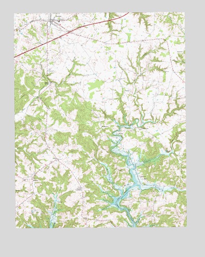
Clarkson, KY USGS Topographic Map
Click on map above to begin viewing in our Map Viewer.

This topographic map contains these locations and features:
Feature Name Type Latitude Longitude GNIS ID View Map
Antioch ChurchChurchN37.3926°W86.2008°485982View Map
Black RockPopulated PlaceN37.4184°W86.1394°507517View Map
Camp LouconLocaleN37.3845°W86.2339°488704View Map
Cedar LickStreamN37.4428°W86.2441°489233View Map
City of ClarksonCivilN37.4937°W86.2259°2404058View Map
ClarksonPopulated PlaceN37.4953°W86.2214°489558View Map
Clarkson Fire and RescueBuildingN37.4944°W86.2198°2636473View Map
Clarkson Police DepartmentBuildingN37.4949°W86.2223°2767526View Map
Confederate HillSummitN37.4572°W86.2214°2742787View Map
Decker CemeteryCemeteryN37.4037°W86.2372°490749View Map
FragrantPopulated PlaceN37.4542°W86.1697°508031View Map
Grayson SpringsPopulated PlaceN37.4592°W86.2244°508123View Map
Grindstone ForkStreamN37.4106°W86.1619°493403View Map
HigdonPopulated PlaceN37.4295°W86.1744°508234View Map
HorntownPopulated PlaceN37.4767°W86.1264°508282View Map
HuffmanPopulated PlaceN37.3901°W86.2191°508291View Map
Hunting ForkStreamN37.3970°W86.1580°494793View Map
Johnson CrossroadsPopulated PlaceN37.3987°W86.2016°508350View Map
Lizard BranchStreamN37.4598°W86.2239°496914View Map
Logsdon CemeteryCemeteryN37.4084°W86.1741°496991View Map
MeredithPopulated PlaceN37.4026°W86.2369°508591View Map
Millerstown DivisionCivilN37.4142°W86.1288°1937147View Map
Mount Moriah ChurchChurchN37.4659°W86.1401°498781View Map
Oak Grove ChurchChurchN37.4612°W86.1730°499688View Map
Pearson BranchStreamN37.3973°W86.1747°500336View Map
PeoniaPopulated PlaceN37.4156°W86.2191°500398View Map
Rock CreekPopulated PlaceN37.4320°W86.1580°508951View Map
Saint Augustines Catholic ChurchChurchN37.4505°W86.2326°502583View Map
SkaggstownPopulated PlaceN37.4337°W86.1866°509069View Map
SnapPopulated PlaceN37.4031°W86.1561°509087View Map
Sulphur Wells ChurchChurchN37.4043°W86.1586°504779View Map

Note: Coordinates in the location and feature list above are referenced to NAD83 datum.


Copyright (C) 2008-2024 Ryan Niemi / Sunset Dynamics ... All Rights Reserved