TopoQuest Logo
Do you find TopoQuest useful?
Help keep TopoQuest running and adding new maps/features by donating!
Bitcoin:  19c7KJd3qBynnjoSw5npx9KScwjBe4ifkT
Litecoin:  LXs6TkuXGGXo1vDsWCkWVdjQX94eUKd6ui
Home View Maps Find Maps Find Places Resources & Links


Big Clifty, Kentucky Topographic Map

USGS Map Title: Big Clifty, KY
USGS Map MRC: 37086E2
DRG (GeoTIFF) Download: o37086e2.tif


Neighboring USGS Topographic Map Quads:


  Custer, KY  
37086F3
 

  Constantine, KY  
37086F2
 

  Howe Valley, KY  
37086F1
 

  Madrid, KY  
37086E3
 

  Big Clifty, KY  
37086E2
 

  Summit, KY  
37086E1
 

  Leitchfield, KY  
37086D3
 

  Clarkson, KY  
37086D2
 

  Millerstown, KY  
37086D1


Map MRC Location:

N38°
W87°
N38°
W86°
H8 H7 H6 H5 H4 H3 H2 H1
G8 G7 G6 G5 G4 G3 G2 G1
F8 F7 F6 F5 F4 F3 F2 F1
E8 E7 E6 E5 E4 E3 E2 E1
D8 D7 D6 D5 D4 D3 D2 D1
C8 C7 C6 C5 C4 C3 C2 C1
B8 B7 B6 B5 B4 B3 B2 B1
A8 A7 A6 A5 A4 A3 A2 A1
N37°
W87°
N37°
W86°

Big Clifty, KY USGS 1:24K Topographic Map Preview:
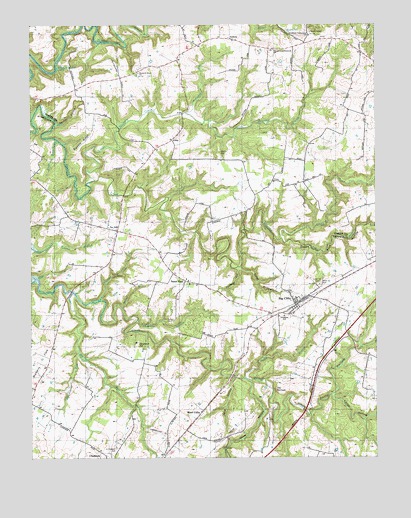
Big Clifty, KY USGS Topographic Map
Click on map above to begin viewing in our Map Viewer.

This topographic map contains these locations and features:
Feature Name Type Latitude Longitude GNIS ID View Map
Barton RunStreamN37.5412°W86.2333°486453View Map
Beaver Dam CreekStreamN37.5517°W86.2486°485668View Map
Big CliftyPopulated PlaceN37.5456°W86.1536°487153View Map
Big Clifty Census Designated PlaceCensusN37.5442°W86.1514°2629577View Map
Bozier BranchStreamN37.5437°W86.2169°487782View Map
Carter HollowValleyN37.5179°W86.1409°489010View Map
Cedar Hill CemeteryCemeteryN37.5498°W86.1452°489216View Map
Chapells BranchStreamN37.5400°W86.2115°489345View Map
Clarkson DivisionCivilN37.5180°W86.1617°1936933View Map
Clifty HollowValleyN37.5125°W86.1488°489689View Map
Cold HollowValleyN37.5231°W86.1763°489792View Map
Crow HollowValleyN37.5222°W86.1713°490409View Map
Decker HollowValleyN37.5964°W86.2403°490750View Map
Double S HillSummitN37.5317°W86.2116°491046View Map
Drane BranchStreamN37.5917°W86.2403°491100View Map
East Grayson County Fire DepartmentBuildingN37.5431°W86.1543°2636296View Map
Flutter CreekStreamN37.5459°W86.2250°492280View Map
Goodman SchoolSchoolN37.5409°W86.1583°492982View Map
Green Rock HollowValleyN37.5628°W86.1587°493302View Map
Grindstone RunStreamN37.5298°W86.2328°493407View Map
LimpPopulated PlaceN37.5923°W86.1975°508465View Map
Little Meeting CreekStreamN37.5806°W86.2272°496797View Map
Mc Grew AirportAirportN37.5074°W86.2042°517354View Map
Moore CemeteryCemeteryN37.5881°W86.1802°498543View Map
Needham Cumberland Presbyterian ChurchChurchN37.6219°W86.1487°499219View Map
Owen HollowValleyN37.5544°W86.1738°500056View Map
Petty BranchStreamN37.5634°W86.1589°500487View Map
Petty CemeteryCemeteryN37.5506°W86.1444°500489View Map
Pleasant Grove CemeteryCemeteryN37.6117°W86.2116°509479View Map
Pleasant Grove ChurchChurchN37.6112°W86.2105°500825View Map
Portman HollowValleyN37.5543°W86.1747°501159View Map
Ripshin RidgeRidgeN37.5906°W86.2311°501965View Map
Saint Elizabeth CemeteryCemeteryN37.5031°W86.2194°502612View Map
Saint PaulPopulated PlaceN37.5509°W86.1936°502712View Map
Saint Pauls CemeteryCemeteryN37.5397°W86.1983°502715View Map
Smith ChapelChurchN37.6228°W86.1483°503773View Map
SolwayPopulated PlaceN37.6212°W86.1766°509091View Map
Sugar BranchStreamN37.5231°W86.1722°504632View Map
Tar HillPopulated PlaceN37.5656°W86.2183°509187View Map
The NarrowsGapN37.5198°W86.1614°505132View Map
Tinker RunStreamN37.5992°W86.1908°505291View Map
West 84 Volunteer Fire Department Station 1BuildingN37.6193°W86.1880°2636865View Map
West CliftyPopulated PlaceN37.5134°W86.1883°509341View Map
Western Consolidated SchoolSchoolN37.6176°W86.1619°506489View Map

Note: Coordinates in the location and feature list above are referenced to NAD83 datum.


Copyright (C) 2008-2024 Ryan Niemi / Sunset Dynamics ... All Rights Reserved