TopoQuest Logo
Do you find TopoQuest useful?
Help keep TopoQuest running and adding new maps/features by donating!
Bitcoin:  19c7KJd3qBynnjoSw5npx9KScwjBe4ifkT
Litecoin:  LXs6TkuXGGXo1vDsWCkWVdjQX94eUKd6ui
Home View Maps Find Maps Find Places Resources & Links


Leitchfield, Kentucky Topographic Map

USGS Map Title: Leitchfield, KY
USGS Map MRC: 37086D3
DRG (GeoTIFF) Download: o37086d3.tif


Neighboring USGS Topographic Map Quads:


  McDaniels, KY  
37086E4
 

  Madrid, KY  
37086E3
 

  Big Clifty, KY  
37086E2
 

  Caneyville, KY  
37086D4
 

  Leitchfield, KY  
37086D3
 

  Clarkson, KY  
37086D2
 

  Ready, KY  
37086C4
 

  Bee Spring, KY  
37086C3
 

  Nolin Lake, KY  
37086C2


Map MRC Location:

N38°
W87°
N38°
W86°
H8 H7 H6 H5 H4 H3 H2 H1
G8 G7 G6 G5 G4 G3 G2 G1
F8 F7 F6 F5 F4 F3 F2 F1
E8 E7 E6 E5 E4 E3 E2 E1
D8 D7 D6 D5 D4 D3 D2 D1
C8 C7 C6 C5 C4 C3 C2 C1
B8 B7 B6 B5 B4 B3 B2 B1
A8 A7 A6 A5 A4 A3 A2 A1
N37°
W87°
N37°
W86°

Leitchfield, KY USGS 1:24K Topographic Map Preview:
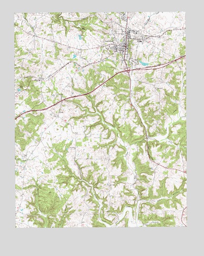
Leitchfield, KY USGS Topographic Map
Click on map above to begin viewing in our Map Viewer.

This topographic map contains these locations and features:
Feature Name Type Latitude Longitude GNIS ID View Map
Allens LakeReservoirN37.4552°W86.3715°485877View Map
Black RockPopulated PlaceN37.4606°W86.3550°507518View Map
Bloomington ChurchChurchN37.4551°W86.2714°487501View Map
Blowtown ChurchChurchN37.3992°W86.3064°487507View Map
ChurchLocaleN37.4423°W86.3425°489508View Map
City of LeitchfieldCivilN37.4863°W86.2857°2404909View Map
Clagett ChurchChurchN37.4884°W86.3641°489523View Map
Criswell HollowValleyN37.4253°W86.2777°490351View Map
Day CliffsCliffN37.4903°W86.3258°490703View Map
Fairview CemeteryCemeteryN37.4842°W86.2772°491901View Map
General ChurchChurchN37.4717°W86.3111°492767View Map
Grayson CountyCivilN37.4608°W86.3439°516889View Map
Grayson County Emergency Medical ServicesBuildingN37.4809°W86.2933°2719068View Map
Grayson County Sheriff's OfficeBuildingN37.4799°W86.2944°2767562View Map
Hargus CreekStreamN37.3753°W86.3053°493744View Map
Hat BranchStreamN37.3759°W86.2864°493855View Map
Helm ForkStreamN37.4378°W86.2544°494009View Map
Hill CemeteryCemeteryN37.4878°W86.3030°494247View Map
Kefauver CemeteryCemeteryN37.4773°W86.3641°495602View Map
LeitchfieldPopulated PlaceN37.4801°W86.2939°496280View Map
Leitchfield DivisionCivilN37.4663°W86.2959°1937101View Map
Leitchfield Fire DepartmentBuildingN37.4781°W86.2937°2636791View Map
Leitchfield Fire Department Station 1BuildingN37.4957°W86.2918°2637388View Map
Leitchfield Police DepartmentBuildingN37.4790°W86.2936°2767510View Map
Leitchfield-Grayson County AirportAirportN37.4005°W86.2610°517411View Map
Liberty ChurchChurchN37.4401°W86.3439°496377View Map
Long BranchStreamN37.3906°W86.2853°497070View Map
McClure ForkStreamN37.4206°W86.2933°497793View Map
Miller ForkStreamN37.4262°W86.2650°498341View Map
New Freedom ChurchChurchN37.4209°W86.3308°499315View Map
Providence ChurchChurchN37.4087°W86.2747°501374View Map
Sadler ChurchChurchN37.3778°W86.3264°502555View Map
Taylor ForkStreamN37.4270°W86.2789°505019View Map
Twin Lakes Regional Medical CenterHospitalN37.4725°W86.2883°2660341View Map
Victory Heights FellowshipChurchN37.4629°W86.2926°2703464View Map
William CemeteryCemeteryN37.4289°W86.3297°506781View Map

Note: Coordinates in the location and feature list above are referenced to NAD83 datum.


Copyright (C) 2008-2025 Ryan Niemi / Sunset Dynamics ... All Rights Reserved