TopoQuest Logo
Do you find TopoQuest useful?
Help keep TopoQuest running and adding new maps/features by donating!
Bitcoin:  19c7KJd3qBynnjoSw5npx9KScwjBe4ifkT
Litecoin:  LXs6TkuXGGXo1vDsWCkWVdjQX94eUKd6ui
Home View Maps Find Maps Find Places Resources & Links


Claytonville, Illinois Topographic Map

USGS Map Title: Claytonville, IL
USGS Map MRC: 40087E7
DRG (GeoTIFF) Download: o40087e7.tif


Neighboring USGS Topographic Map Quads:


  Onarga East, IL  
40087F8
 

  Woodworth, IL  
40087F7
 

  Milford, IL  
40087F6
 

  Cissna Park, IL  
40087E8
 

  Claytonville, IL  
40087E7
 

  Wellington, IL  
40087E6
 

  Rankin, IL  
40087D8
 

  East Lynn, IL  
40087D7
 

  Hoopeston, IL  
40087D6


Map MRC Location:

N41°
W88°
N41°
W87°
H8 H7 H6 H5 H4 H3 H2 H1
G8 G7 G6 G5 G4 G3 G2 G1
F8 F7 F6 F5 F4 F3 F2 F1
E8 E7 E6 E5 E4 E3 E2 E1
D8 D7 D6 D5 D4 D3 D2 D1
C8 C7 C6 C5 C4 C3 C2 C1
B8 B7 B6 B5 B4 B3 B2 B1
A8 A7 A6 A5 A4 A3 A2 A1
N40°
W88°
N40°
W87°

Claytonville, IL USGS 1:24K Topographic Map Preview:
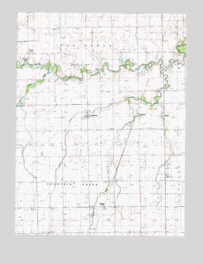
Claytonville, IL USGS Topographic Map
Click on map above to begin viewing in our Map Viewer.

This topographic map contains these locations and features:
Feature Name Type Latitude Longitude GNIS ID View Map
Amity CemeteryCemeteryN40.5602°W87.7647°403489View Map
Apostolic Christian ChurchChurchN40.5439°W87.8556°403569View Map
Ash Grove CemeteryCemeteryN40.5964°W87.8482°403662View Map
Beebe FarmsLocaleN40.5706°W87.8242°2741125View Map
Bundan School (historical)SchoolN40.5020°W87.8584°405189View Map
Carey School (historical)SchoolN40.5120°W87.7834°405584View Map
ClaytonvillePopulated PlaceN40.5670°W87.8231°406197View Map
Claytonville Post OfficePost OfficeN40.5663°W87.8221°1815549View Map
Eisenmann FarmsLocaleN40.5153°W87.8167°2741126View Map
Fairview School (historical)SchoolN40.6242°W87.7859°408223View Map
Fountain CreekPopulated PlaceN40.5161°W87.8109°422709View Map
Fountain CreekStreamN40.5945°W87.7636°408582View Map
GoodwinePopulated PlaceN40.5673°W87.7845°409157View Map
Goodwine Post OfficePost OfficeN40.5675°W87.7847°1815559View Map
HickmanPopulated PlaceN40.5675°W87.7645°422802View Map
Laird School (historical)SchoolN40.5853°W87.7506°411694View Map
Leemon School (historical)SchoolN40.5086°W87.8200°411916View Map
Little Mud CreekStreamN40.5934°W87.8511°412379View Map
Miller Spring LakeReservoirN40.5972°W87.8684°413607View Map
Old Apostolic CemeteryCemeteryN40.5117°W87.8017°1951821View Map
Perfume AcresLocaleN40.5397°W87.8383°2741159View Map
Pigeon CreekStreamN40.5934°W87.8520°415655View Map
PitchinPopulated PlaceN40.6031°W87.8664°423069View Map
Possum Trot School (historical)SchoolN40.5789°W87.8606°416066View Map
Ravens FarmLocaleN40.5347°W87.7619°2741164View Map
Ristow FarmsLocaleN40.5317°W87.8044°2741127View Map
Township of Fountain CreekCivilN40.5306°W87.8223°429018View Map
Whisky CreekStreamN40.5775°W87.7936°421008View Map
Willoughby School (historical)SchoolN40.5998°W87.8189°421222View Map
Wise School (historical)SchoolN40.5461°W87.8123°421354View Map

Note: Coordinates in the location and feature list above are referenced to NAD83 datum.


Copyright (C) 2008-2024 Ryan Niemi / Sunset Dynamics ... All Rights Reserved