TopoQuest Logo
Do you find TopoQuest useful?
Help keep TopoQuest running and adding new maps/features by donating!
Bitcoin:  19c7KJd3qBynnjoSw5npx9KScwjBe4ifkT
Litecoin:  LXs6TkuXGGXo1vDsWCkWVdjQX94eUKd6ui
Home View Maps Find Maps Find Places Resources & Links


Battle Flat, Arizona Topographic Map

USGS Map Title: Battle Flat, AZ
USGS Map MRC: 34112C3
DRG (GeoTIFF) Download: o34112c3.tif


Neighboring USGS Topographic Map Quads:


  Groom Creek, AZ  
34112D4
 

  Poland Junction, AZ  
34112D3
 

  Mayer, AZ  
34112D2
 

  Battleship Butte, AZ  
34112C4
 

  Battle Flat, AZ  
34112C3
 

  Cleator, AZ  
34112C2
 

  Minnehaha, AZ  
34112B4
 

  Crown King, AZ  
34112B3
 

  Bumble Bee, AZ  
34112B2


Map MRC Location:

N35°
W113°
N35°
W112°
H8 H7 H6 H5 H4 H3 H2 H1
G8 G7 G6 G5 G4 G3 G2 G1
F8 F7 F6 F5 F4 F3 F2 F1
E8 E7 E6 E5 E4 E3 E2 E1
D8 D7 D6 D5 D4 D3 D2 D1
C8 C7 C6 C5 C4 C3 C2 C1
B8 B7 B6 B5 B4 B3 B2 B1
A8 A7 A6 A5 A4 A3 A2 A1
N34°
W113°
N34°
W112°

Battle Flat, AZ USGS 1:24K Topographic Map Preview:
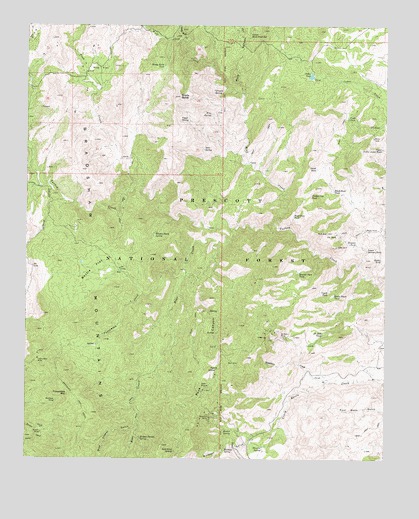
Battle Flat, AZ USGS Topographic Map
Click on map above to begin viewing in our Map Viewer.

This topographic map contains these locations and features:
Feature Name Type Latitude Longitude GNIS ID View Map
Arrastra CreekStreamN34.3281°W112.3702°25762View Map
Battle FlatFlatN34.3045°W112.3527°26042View Map
Battle Flat Trick TankReservoirN34.3178°W112.3591°41006View Map
Bear CreekStreamN34.3167°W112.3032°26085View Map
Black Rock TankReservoirN34.3275°W112.2690°26447View Map
Blancho SpringSpringN34.2533°W112.2929°26476View Map
Boulder Dam TankReservoirN34.3040°W112.2809°26649View Map
Bradshaw TrailTrailN34.2639°W112.3552°26708View Map
Brady ButteSummitN34.3545°W112.3229°26709View Map
Brady Butte TankReservoirN34.3633°W112.3283°26710View Map
Brushy Basin SpringSpringN34.3154°W112.3309°26822View Map
Bucket SpringSpringN34.2587°W112.3040°26898View Map
Buster MineMineN34.2575°W112.3702°27070View Map
Cedar TankReservoirN34.3605°W112.2769°27442View Map
Coyote SpringSpringN34.2989°W112.2809°41008View Map
Coyote TankReservoirN34.2981°W112.2705°28132View Map
Crooked Leg TankReservoirN34.3260°W112.2769°28178View Map
De Soto MineMineN34.2853°W112.2863°28313View Map
De Soto TankReservoirN34.2861°W112.2726°28314View Map
Deer SpringSpringN34.3394°W112.3142°28391View Map
Fence TankReservoirN34.3486°W112.2640°28971View Map
Goat RanchLocaleN34.3050°W112.3207°38462View Map
Gold King MineMineN34.2514°W112.3293°38463View Map
Gold King SpringSpringN34.2525°W112.3241°29389View Map
Granite SpringSpringN34.3562°W112.3110°29495View Map
Harl TankMineN34.3428°W112.2579°38492View Map
Hawkey WellWellN34.3203°W112.3432°38498View Map
Hidden Tunnel SpringSpringN34.2560°W112.3356°29952View Map
Juniper SpringSpringN34.3697°W112.3635°38547View Map
Little Wolf CreekStreamN34.3709°W112.3216°31151View Map
Lower Mule Creek SpringSpringN34.3717°W112.2990°31371View Map
Lower Skinner TankReservoirN34.3105°W112.2571°31377View Map
Middleton CreekStreamN34.2723°W112.2713°31835View Map
Mineral Creek Dam TankReservoirN34.3373°W112.2646°38632View Map
Mohawk MineMineN34.2664°W112.3654°31947View Map
Muldoon GulchValleyN34.2617°W112.2877°32160View Map
Muldoon SpringSpringN34.2529°W112.3064°32161View Map
Mule CanyonValleyN34.3553°W112.3010°32164View Map
Peck CanyonValleyN34.3036°W112.3199°32767View Map
Peck MineMineN34.2711°W112.3121°32768View Map
Peck SpringSpringN34.2761°W112.3092°32770View Map
Pine CreekStreamN34.3284°W112.3354°32926View Map
Pine FlatFlatN34.3625°W112.3507°32933View Map
Poor Mans SpringSpringN34.2645°W112.2557°38710View Map
Rocky SpringSpringN34.3592°W112.3118°38761View Map
S A HillSummitN34.3153°W112.2710°33904View Map
S A TankReservoirN34.3150°W112.2680°33905View Map
SA Hill Trick TankReservoirN34.3150°W112.2680°41007View Map
Sandrock SpringSpringN34.2536°W112.2604°38778View Map
Skinner TankReservoirN34.3121°W112.2610°34491View Map
Small TankReservoirN34.3339°W112.2750°34540View Map
Snake Track TankReservoirN34.2972°W112.2686°34586View Map
Stump TankReservoirN34.3077°W112.2523°34910View Map
Swastika MineMineN34.2620°W112.3113°34996View Map
T D TankReservoirN34.3460°W112.2566°35070View Map
The Troughs SpringSpringN34.3250°W112.3088°38872View Map
Turkey SpringSpringN34.3211°W112.3291°38895View Map
Tuscumbia CreekStreamN34.3025°W112.3207°35595View Map
Tuscumbia MineMineN34.2786°W112.3716°35596View Map
Tuscumbia MountainSummitN34.2684°W112.3607°35597View Map
Upper SpringSpringN34.3474°W112.3223°35712View Map
Upper Yellow Jacket TankReservoirN34.3395°W112.2521°35735View Map
West Side Trick TankReservoirN34.2961°W112.2713°41009View Map
Wild Flower GulchValleyN34.2611°W112.3366°36160View Map
Wire SpringSpringN34.3494°W112.3119°36344View Map
Wolf CreekStreamN34.3161°W112.2877°36352View Map
Wolf Creek TankReservoirN34.3202°W112.2828°36353View Map

Note: Coordinates in the location and feature list above are referenced to NAD83 datum.


Copyright (C) 2008-2025 Ryan Niemi / Sunset Dynamics ... All Rights Reserved