TopoQuest Logo
Do you find TopoQuest useful?
Help keep TopoQuest running and adding new maps/features by donating!
Bitcoin:  19c7KJd3qBynnjoSw5npx9KScwjBe4ifkT
Litecoin:  LXs6TkuXGGXo1vDsWCkWVdjQX94eUKd6ui
Home View Maps Find Maps Find Places Resources & Links


Clubhouse Crossroads, South Carolina Topographic Map

USGS Map Title: Clubhouse Crossroads, SC
USGS Map MRC: 32080H3
DRG (GeoTIFF) Download: o32080h3.tif


Neighboring USGS Topographic Map Quads:


  Maple Cane Swamp, SC  
33080A4
 

  Ridgeville, SC  
33080A3
 

  Summerville, SC  
33080A2
 

  Cottageville, SC  
32080H4
 

  Clubhouse Crossroads, SC  
32080H3
 

  Stallsville, SC  
32080H2
 

  Jacksonboro, SC  
32080G4
 

  Osborn, SC  
32080G3
 

  Ravenel, SC  
32080G2


Map MRC Location:

N33°
W81°
N33°
W80°
H8 H7 H6 H5 H4 H3 H2 H1
G8 G7 G6 G5 G4 G3 G2 G1
F8 F7 F6 F5 F4 F3 F2 F1
E8 E7 E6 E5 E4 E3 E2 E1
D8 D7 D6 D5 D4 D3 D2 D1
C8 C7 C6 C5 C4 C3 C2 C1
B8 B7 B6 B5 B4 B3 B2 B1
A8 A7 A6 A5 A4 A3 A2 A1
N32°
W81°
N32°
W80°

Clubhouse Crossroads, SC USGS 1:24K Topographic Map Preview:
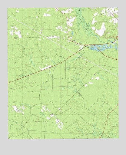
Clubhouse Crossroads, SC USGS Topographic Map
Click on map above to begin viewing in our Map Viewer.

This topographic map contains these locations and features:
Feature Name Type Latitude Longitude GNIS ID View Map
Beech Hill CemeteryCemeteryN32.9716°W80.3673°1220467View Map
Beech Hill Church (historical)ChurchN32.9718°W80.3679°1241040View Map
Beech Hill School (historical)SchoolN32.9718°W80.3676°1241041View Map
Bobs LakeLakeN32.9972°W80.2919°1220845View Map
Buck Dam SwampSwampN32.8988°W80.3360°1241056View Map
CanaanPopulated PlaceN32.9657°W80.2943°1231132View Map
Canaan School (historical)SchoolN32.9671°W80.2984°1241060View Map
Canaan United Methodist ChurchChurchN32.9638°W80.2876°1241061View Map
Clubhouse CrossroadsPopulated PlaceN32.8980°W80.3226°1247325View Map
Coachmans CornersPopulated PlaceN32.9679°W80.3018°1231180View Map
Drayton Dam (historical)DamN32.9152°W80.3243°1241087View Map
Faith ChurchChurchN32.9971°W80.2534°1247720View Map
GettysvillePopulated PlaceN32.9018°W80.3640°1231312View Map
Givhans Alternative SchoolSchoolN32.9649°W80.2951°1245749View Map
Knightsville ChurchChurchN32.9988°W80.2607°1246268View Map
Magnolia CemeteryCemeteryN32.9882°W80.3070°1224267View Map
Marsh PondLakeN32.9531°W80.2943°1224331View Map
Negro Lake (historical)LakeN32.9708°W80.2570°1241154View Map
Old Fort Fire Department Station 7BuildingN32.9795°W80.2538°2737359View Map
Rosom HillSummitN32.9471°W80.2909°1250474View Map
Rosom Hill CemeteryCemeteryN32.9421°W80.2915°1226033View Map
Sand Hill ChurchChurchN32.8910°W80.3320°1250750View Map
Sand Hill School (historical)SchoolN32.8910°W80.3323°1241206View Map
Sandhill Volunteer Fire Department Number 1BuildingN32.8913°W80.3331°2368094View Map
Schultz LakeLakeN32.9723°W80.2736°1226447View Map
Scotts CreekStreamN32.9329°W80.3098°1226460View Map
Shepherd Grove CemeteryCemeteryN32.9235°W80.3715°1226558View Map
Shepherd Grove ChurchChurchN32.9238°W80.3718°1241213View Map
Shepherd Grove School (historical)SchoolN32.9232°W80.3712°1241214View Map
Slands BridgeBridgeN32.9685°W80.2529°1250926View Map
The ForksLocaleN32.9643°W80.2843°1227077View Map
Waringville (historical)Populated PlaceN32.9352°W80.2776°1241261View Map
Winwright (historical)Populated PlaceN32.8818°W80.2879°1241269View Map

Note: Coordinates in the location and feature list above are referenced to NAD83 datum.


Copyright (C) 2008-2024 Ryan Niemi / Sunset Dynamics ... All Rights Reserved