TopoQuest Logo
Do you find TopoQuest useful?
Help keep TopoQuest running and adding new maps/features by donating!
Bitcoin:  19c7KJd3qBynnjoSw5npx9KScwjBe4ifkT
Litecoin:  LXs6TkuXGGXo1vDsWCkWVdjQX94eUKd6ui
Home View Maps Find Maps Find Places Resources & Links


Cottageville, South Carolina Topographic Map

USGS Map Title: Cottageville, SC
USGS Map MRC: 32080H4
DRG (GeoTIFF) Download: o32080h4.tif


Neighboring USGS Topographic Map Quads:


  Canadys, SC  
33080A5
 

  Maple Cane Swamp, SC  
33080A4
 

  Ridgeville, SC  
33080A3
 

  Round O, SC  
32080H5
 

  Cottageville, SC  
32080H4
 

  Clubhouse Crossroads, SC  
32080H3
 

  Neyles, SC  
32080G5
 

  Jacksonboro, SC  
32080G4
 

  Osborn, SC  
32080G3


Map MRC Location:

N33°
W81°
N33°
W80°
H8 H7 H6 H5 H4 H3 H2 H1
G8 G7 G6 G5 G4 G3 G2 G1
F8 F7 F6 F5 F4 F3 F2 F1
E8 E7 E6 E5 E4 E3 E2 E1
D8 D7 D6 D5 D4 D3 D2 D1
C8 C7 C6 C5 C4 C3 C2 C1
B8 B7 B6 B5 B4 B3 B2 B1
A8 A7 A6 A5 A4 A3 A2 A1
N32°
W81°
N32°
W80°

Cottageville, SC USGS 1:24K Topographic Map Preview:
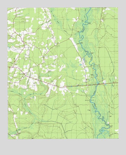
Cottageville, SC USGS Topographic Map
Click on map above to begin viewing in our Map Viewer.

This topographic map contains these locations and features:
Feature Name Type Latitude Longitude GNIS ID View Map
Ackerman CemeteryCemeteryN32.9852°W80.4523°1220126View Map
Adams CemeteryCemeteryN32.9516°W80.4907°1220130View Map
Big Bay SwampSwampN32.9896°W80.4457°1220660View Map
Big Swamp (historical)SwampN32.8874°W80.4290°1240564View Map
Camp BuddyLocaleN32.9105°W80.4073°1240574View Map
Church Hill CemeteryCemeteryN32.8793°W80.4887°1221595View Map
Colleton Fire Department Station 9BuildingN32.9463°W80.4931°2368279View Map
CottagevillePopulated PlaceN32.9368°W80.4809°1231198View Map
Cottageville Baptist ChurchChurchN32.9374°W80.4807°1240602View Map
Cottageville ChurchChurchN32.9318°W80.4670°1240603View Map
Cottageville DivisionCivilN32.9400°W80.4819°1938239View Map
Cottageville Elementary SchoolSchoolN32.9335°W80.4817°1240604View Map
Cottageville Fire DepartmentBuildingN32.9354°W80.4784°2578734View Map
Cottageville Lookout TowerTowerN32.9257°W80.4212°1240605View Map
Cottageville Police DepartmentBuildingN32.9336°W80.4813°2334996View Map
Cottageville Post OfficePost OfficeN32.9351°W80.4774°2489784View Map
Craven BranchStreamN32.9888°W80.4459°1221820View Map
Deep CreekStreamN32.9860°W80.4126°1221976View Map
GlovervillePopulated PlaceN32.9002°W80.4934°1231323View Map
Gloverville School (historical)SchoolN32.9071°W80.4970°1240643View Map
Goodhope LandingPopulated PlaceN32.9657°W80.4184°1245774View Map
Harts BluffCliffN32.9268°W80.3976°1245921View Map
Harts Bluff BridgeBridgeN32.9268°W80.3984°1241118View Map
Hickory Hill ChurchChurchN32.9660°W80.4432°1223138View Map
Hughes CemeteryCemeteryN32.9732°W80.4959°1223384View Map
Jericho ChurchChurchN32.9532°W80.4590°1223553View Map
Jericho School (historical)SchoolN32.9527°W80.4590°1240658View Map
Jones LakeLakeN32.9871°W80.4158°1223643View Map
Kelsey Cove LandingPopulated PlaceN32.9566°W80.4062°1231442View Map
Leveston BluffCliffN32.8868°W80.3845°1223882View Map
Logging SavannaSwampN32.9202°W80.4912°1224102View Map
Long Creek LandingPopulated PlaceN32.9354°W80.4029°1231503View Map
Macedonia CemeteryCemeteryN32.9024°W80.4065°1224240View Map
Macedonia ChurchChurchN32.9321°W80.4112°1224243View Map
Metz Store (historical)Populated PlaceN32.9918°W80.4901°1240678View Map
Norman LandingPopulated PlaceN32.9846°W80.4084°1231595View Map
Oats HoleSwampN32.9185°W80.4684°1225159View Map
Parker HoleLakeN32.9443°W80.4064°1225301View Map
Prices LandingPopulated PlaceN32.9774°W80.4179°1231689View Map
Red Oak ChurchChurchN32.9813°W80.4532°1250313View Map
Red Oak CornerPopulated PlaceN32.9641°W80.4465°1227970View Map
Redoak School (historical)SchoolN32.9810°W80.4526°1240716View Map
Reeves CemeteryCemeteryN32.8963°W80.3848°1225827View Map
Reevestown BranchStreamN32.9210°W80.4809°1225828View Map
Rehoboth School (historical)SchoolN32.9999°W80.4882°1240717View Map
Round O CemeteryCemeteryN32.8804°W80.4884°1226045View Map
Sandhill School (historical)SchoolN32.9260°W80.4484°1240737View Map
Sandy RunStreamN32.9760°W80.4190°1226380View Map
Spooler SwampSwampN32.9314°W80.3818°1226794View Map
Springhill ChurchChurchN32.9646°W80.4809°1251016View Map
Sullivans Church (historical)ChurchN32.8968°W80.3851°1241226View Map
Sullivans FerryLocaleN32.9121°W80.4068°1226954View Map
Sullivans Ferry (historical)CrossingN32.9121°W80.4062°1241231View Map
Sullivans Ferry CrossroadsLocaleN32.9080°W80.3848°1241232View Map
Town of CottagevilleCivilN32.9362°W80.4803°2406317View Map
Warrens SavannaSwampN32.9038°W80.4773°1227407View Map
Williams CemeteryCemeteryN32.9399°W80.4534°1227610View Map

Note: Coordinates in the location and feature list above are referenced to NAD83 datum.


Copyright (C) 2008-2025 Ryan Niemi / Sunset Dynamics ... All Rights Reserved