TopoQuest Logo
Do you find TopoQuest useful?
Help keep TopoQuest running and adding new maps/features by donating!
Bitcoin:  19c7KJd3qBynnjoSw5npx9KScwjBe4ifkT
Litecoin:  LXs6TkuXGGXo1vDsWCkWVdjQX94eUKd6ui
Home View Maps Find Maps Find Places Resources & Links


Jacksonboro, South Carolina Topographic Map

USGS Map Title: Jacksonboro, SC
USGS Map MRC: 32080G4
DRG (GeoTIFF) Download: o32080g4.tif


Neighboring USGS Topographic Map Quads:


  Round O, SC  
32080H5
 

  Cottageville, SC  
32080H4
 

  Clubhouse Crossroads, SC  
32080H3
 

  Neyles, SC  
32080G5
 

  Jacksonboro, SC  
32080G4
 

  Osborn, SC  
32080G3
 

  Green Pond, SC  
32080F5
 

  Fenwick, SC  
32080F4
 

  Adams Run, SC  
32080F3


Map MRC Location:

N33°
W81°
N33°
W80°
H8 H7 H6 H5 H4 H3 H2 H1
G8 G7 G6 G5 G4 G3 G2 G1
F8 F7 F6 F5 F4 F3 F2 F1
E8 E7 E6 E5 E4 E3 E2 E1
D8 D7 D6 D5 D4 D3 D2 D1
C8 C7 C6 C5 C4 C3 C2 C1
B8 B7 B6 B5 B4 B3 B2 B1
A8 A7 A6 A5 A4 A3 A2 A1
N32°
W81°
N32°
W80°

Jacksonboro, SC USGS 1:24K Topographic Map Preview:
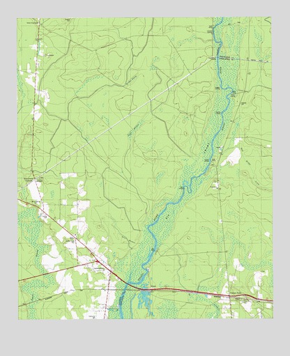
Jacksonboro, SC USGS Topographic Map
Click on map above to begin viewing in our Map Viewer.

This topographic map contains these locations and features:
Feature Name Type Latitude Longitude GNIS ID View Map
Allen MeadowSwampN32.7832°W80.4462°1220165View Map
Baptist Church BranchStreamN32.8380°W80.4976°1220317View Map
Beck LandingPopulated PlaceN32.8046°W80.4187°1231040View Map
Bluefield Hunting ClubLocaleN32.7980°W80.4782°1240567View Map
Bull Bridge CreekStreamN32.8193°W80.4032°1221096View Map
Burden SwampSwampN32.8495°W80.4434°1221129View Map
Burnt Church CrossroadsPopulated PlaceN32.8082°W80.4915°1247069View Map
Buzzard Roost CemeteryCemeteryN32.7824°W80.4718°1221178View Map
Canady LandingPopulated PlaceN32.8155°W80.4048°1231133View Map
Cedar Grove School (historical)SchoolN32.8060°W80.4948°1240584View Map
Church of GodChurchN32.7649°W80.3973°1252773View Map
Colleton Fire Department Station 2BuildingN32.7717°W80.4631°2368305View Map
Community CemeteryCemeteryN32.7504°W80.4626°1240599View Map
Edisto Sand PitMineN32.7588°W80.4373°1252821View Map
Elliot Swamp (historical)SwampN32.7707°W80.4734°1240614View Map
Eureka School (historical)SchoolN32.7902°W80.3998°1252826View Map
Fishburn LandingLocaleN32.8138°W80.4054°1252853View Map
Green MeadowSwampN32.8266°W80.4443°1222875View Map
Haynes CemeteryCemeteryN32.8068°W80.4798°1223098View Map
Henry James Swamp (historical)SwampN32.8118°W80.4945°1240636View Map
Hopewell CemeteryCemeteryN32.8393°W80.3904°1223279View Map
Hopewell ChurchChurchN32.8043°W80.4018°1223285View Map
Iron CrossroadsPopulated PlaceN32.8730°W80.4887°1246126View Map
Irons Cross Roads School (historical)SchoolN32.8660°W80.4893°1240650View Map
Isaac Hayne TombCemeteryN32.8071°W80.4798°1240651View Map
JacksonboroPopulated PlaceN32.7702°W80.4545°1246146View Map
Jacksonboro Census Designated PlaceCensusN32.7718°W80.4769°2629834View Map
Jacksonboro ChurchChurchN32.7852°W80.4715°1240655View Map
Jacksonboro Post OfficePost OfficeN32.7723°W80.4584°2489846View Map
Jacksonboro School (historical)SchoolN32.7841°W80.4712°1240656View Map
Jenkins Swamp (historical)SwampN32.8607°W80.4432°1240657View Map
Lowndes LandingPopulated PlaceN32.8685°W80.4037°1224220View Map
Martins LandingPopulated PlaceN32.8435°W80.3943°1231520View Map
Oak Grove School (historical)SchoolN32.7902°W80.4804°1240691View Map
Padgett LandingPopulated PlaceN32.8455°W80.3995°1231623View Map
Parkers FerryPopulated PlaceN32.7602°W80.3962°1231631View Map
Parkers Ferry (historical)CrossingN32.8585°W80.4012°1240697View Map
Parkers Ferry LandingPopulated PlaceN32.8593°W80.4037°1231632View Map
Parkers Ferry School (historical)SchoolN32.7510°W80.3957°1253097View Map
Pine Hill LandingPopulated PlaceN32.8355°W80.3995°1231656View Map
Pine Hill School (historical)SchoolN32.8352°W80.4162°1240708View Map
PonponPopulated PlaceN32.7618°W80.4348°1227967View Map
Saint Johns Swamp (historical)SwampN32.8593°W80.4776°1240731View Map
Saint Marks ChurchChurchN32.7571°W80.3876°1226189View Map
Sanders CemeteryCemeteryN32.8749°W80.4734°1226342View Map
Trinity ChurchChurchN32.8663°W80.4893°1251202View Map
Trinity School (historical)SchoolN32.8260°W80.4918°1240769View Map
White Meeting CemeteryCemeteryN32.7977°W80.4912°1227539View Map

Note: Coordinates in the location and feature list above are referenced to NAD83 datum.


Copyright (C) 2008-2025 Ryan Niemi / Sunset Dynamics ... All Rights Reserved