TopoQuest Logo
Do you find TopoQuest useful?
Help keep TopoQuest running and adding new maps/features by donating!
Bitcoin:  19c7KJd3qBynnjoSw5npx9KScwjBe4ifkT
Litecoin:  LXs6TkuXGGXo1vDsWCkWVdjQX94eUKd6ui
Home View Maps Find Maps Find Places Resources & Links


Coleman, Michigan Topographic Map

USGS Map Title: Coleman, MI
USGS Map MRC: 43084G5
DRG (GeoTIFF) Download: o43084g5.tif


Neighboring USGS Topographic Map Quads:


  Browns Corners, MI  
43084H6
 

  Coleman NE, MI  
43084H5
 

  Gladwin, MI  
43084H4
 

  Loomis, MI  
43084G6
 

  Coleman, MI  
43084G5
 

  Edenville, MI  
43084G4
 

  Leaton, MI  
43084F6
 

  Alamando, MI  
43084F5
 

  Sanford, MI  
43084F4


Map MRC Location:

N44°
W85°
N44°
W84°
H8 H7 H6 H5 H4 H3 H2 H1
G8 G7 G6 G5 G4 G3 G2 G1
F8 F7 F6 F5 F4 F3 F2 F1
E8 E7 E6 E5 E4 E3 E2 E1
D8 D7 D6 D5 D4 D3 D2 D1
C8 C7 C6 C5 C4 C3 C2 C1
B8 B7 B6 B5 B4 B3 B2 B1
A8 A7 A6 A5 A4 A3 A2 A1
N43°
W85°
N43°
W84°

Coleman, MI USGS 1:24K Topographic Map Preview:
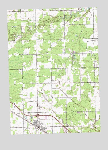
Coleman, MI USGS Topographic Map
Click on map above to begin viewing in our Map Viewer.

This topographic map contains these locations and features:
Feature Name Type Latitude Longitude GNIS ID View Map
Bailey CreekStreamN43.8492°W84.6120°620447View Map
Bickerton DrainCanalN43.7828°W84.5908°621277View Map
Black CreekStreamN43.8661°W84.5350°621477View Map
Bliss DrainCanalN43.7867°W84.5197°621590View Map
City of ColemanCivilN43.7589°W84.5871°1626110View Map
ColemanPopulated PlaceN43.7567°W84.5858°623595View Map
Coleman Area LibraryBuildingN43.7553°W84.5828°2544673View Map
Coleman Assembly of God ChurchChurchN43.7572°W84.5800°2544669View Map
Coleman Community Fire DepartmentBuildingN43.7556°W84.5837°2626934View Map
Coleman Community High SchoolSchoolN43.7550°W84.5681°2544681View Map
Coleman Elementary SchoolSchoolN43.7547°W84.5750°2544680View Map
Coleman Family Medical CenterHospitalN43.7514°W84.5786°2544671View Map
Coleman Middle SchoolSchoolN43.7525°W84.5761°2544679View Map
Coleman Police DepartmentBuildingN43.7572°W84.5875°2544674View Map
Coleman Post OfficePost OfficeN43.7564°W84.5850°2544676View Map
Coleman Station (historical)LocaleN43.7581°W84.5903°2544675View Map
Coleman Wesleyan ChurchChurchN43.7558°W84.5897°2544665View Map
Community of Christ ChurchChurchN43.7572°W84.5831°2544668View Map
Daniels Band ChurchChurchN43.8478°W84.5861°624299View Map
Davidson CreekStreamN43.8653°W84.5528°624328View Map
Dunbar DrainCanalN43.8311°W84.5158°624977View Map
Faith United Methodist ChurchChurchN43.7589°W84.5856°2544667View Map
Grace Baptist ChurchChurchN43.7625°W84.5847°2544666View Map
High DrainCanalN43.7914°W84.6042°628227View Map
Holley ChapelChurchN43.8006°W84.5861°628433View Map
Howe DrainCanalN43.7845°W84.5400°628709View Map
Lost Haven CampgroundLocaleN43.8319°W84.5475°2515895View Map
LylePopulated PlaceN43.8292°W84.5375°2515956View Map
Lyle DrainCanalN43.8495°W84.5450°631225View Map
Lyle Post Office (historical)Post OfficeN43.8292°W84.5375°2515957View Map
Lyle Station (historical)LocaleN43.8292°W84.5378°2515951View Map
MidMichigan Medical Center Emergency Medical Services Station 10BuildingN43.7534°W84.5792°2662014View Map
Rilett DrainCanalN43.8639°W84.5950°635929View Map
Saint Philip Neri ChurchChurchN43.7564°W84.5744°2544670View Map
South Beaverton Oil FieldOilfieldN43.8256°W84.5100°1623641View Map
Southgate Mobile VillagePopulated PlaceN43.7514°W84.5894°2544678View Map
Township of BeavertonCivilN43.8579°W84.5470°1625904View Map
Township of WarrenCivilN43.7717°W84.5450°1627214View Map
West Beaverton Oil FieldOilfieldN43.8547°W84.5970°1623696View Map
WSMZ-FM (Coleman)TowerN43.7736°W84.5272°1625669View Map

Note: Coordinates in the location and feature list above are referenced to NAD83 datum.


Copyright (C) 2008-2025 Ryan Niemi / Sunset Dynamics ... All Rights Reserved