TopoQuest Logo
Do you find TopoQuest useful?
Help keep TopoQuest running and adding new maps/features by donating!
Bitcoin:  19c7KJd3qBynnjoSw5npx9KScwjBe4ifkT
Litecoin:  LXs6TkuXGGXo1vDsWCkWVdjQX94eUKd6ui
Home View Maps Find Maps Find Places Resources & Links


Sanford, Michigan Topographic Map

USGS Map Title: Sanford, MI
USGS Map MRC: 43084F4
DRG (GeoTIFF) Download: o43084f4.tif


Neighboring USGS Topographic Map Quads:


  Coleman, MI  
43084G5
 

  Edenville, MI  
43084G4
 

  Hope, MI  
43084G3
 

  Alamando, MI  
43084F5
 

  Sanford, MI  
43084F4
 

  Averill, MI  
43084F3
 

  Pleasant Valley, MI  
43084E5
 

  Floyd, MI  
43084E4
 

  Gordonville, MI  
43084E3


Map MRC Location:

N44°
W85°
N44°
W84°
H8 H7 H6 H5 H4 H3 H2 H1
G8 G7 G6 G5 G4 G3 G2 G1
F8 F7 F6 F5 F4 F3 F2 F1
E8 E7 E6 E5 E4 E3 E2 E1
D8 D7 D6 D5 D4 D3 D2 D1
C8 C7 C6 C5 C4 C3 C2 C1
B8 B7 B6 B5 B4 B3 B2 B1
A8 A7 A6 A5 A4 A3 A2 A1
N43°
W85°
N43°
W84°

Sanford, MI USGS 1:24K Topographic Map Preview:
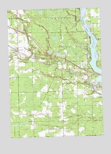
Sanford, MI USGS Topographic Map
Click on map above to begin viewing in our Map Viewer.

This topographic map contains these locations and features:
Feature Name Type Latitude Longitude GNIS ID View Map
Black CreekStreamN43.7028°W84.3889°621485View Map
Black Creek Forest CampgroundLocaleN43.7103°W84.3914°621499View Map
Black DrainCanalN43.6681°W84.4058°621502View Map
Bluff CreekStreamN43.7078°W84.4656°621654View Map
Church of Christ RestoredChurchN43.6653°W84.3889°2544641View Map
Church of Jesus Christ of Latter Day SaintsChurchN43.6800°W84.3906°2544646View Map
Cleft of the Rock Family ChurchChurchN43.6850°W84.3942°2544645View Map
Community of ChristChurchN43.6717°W84.3783°2544640View Map
Durbin DrainCanalN43.6675°W84.4397°625019View Map
Edenville Fire and Rescue Station 2BuildingN43.7473°W84.4074°2626924View Map
Francis GrovePopulated PlaceN43.7209°W84.3900°626395View Map
Geneva CemeteryCemeteryN43.7072°W84.4883°626721View Map
Geneva Community CemeteryCemeteryN43.7133°W84.4875°2544579View Map
Jerome Township CemeteryCemeteryN43.6758°W84.3781°2544232View Map
Jerome Township Fire Department Station 1BuildingN43.6798°W84.3975°2626758View Map
Jerome Township HallBuildingN43.7044°W84.3939°2544647View Map
Midland CountyCivilN43.6469°W84.3881°1622998View Map
Mud CreekStreamN43.6978°W84.4339°632883View Map
North BradleyPopulated PlaceN43.7114°W84.4900°633484View Map
North Bradley Church of GodChurchN43.7089°W84.4906°2544682View Map
North Bradley Post Office (historical)Post OfficeN43.7114°W84.4900°2544204View Map
North Bradley Station (historical)LocaleN43.7111°W84.4908°2544189View Map
OlsonPopulated PlaceN43.6256°W84.4292°1617762View Map
Olson Community ChurchChurchN43.6264°W84.4289°2544654View Map
Olson Post Office (historical)Post OfficeN43.6256°W84.4292°2544203View Map
Origins of the Salt Industry Historical MarkerParkN43.6728°W84.3844°2544688View Map
Saint Agnes Roman Catholic ChurchChurchN43.6814°W84.3928°2544642View Map
Salt RiverStreamN43.6739°W84.3889°637139View Map
SanfordPopulated PlaceN43.6728°W84.3806°637235View Map
Sanford Historical MuseumBuildingN43.6783°W84.3889°2544639View Map
Sanford LakeReservoirN43.6954°W84.3881°637242View Map
Sanford Lake MarinaLocaleN43.7325°W84.3897°2544638View Map
Sanford Lake ParkParkN43.6822°W84.3831°637243View Map
Sanford Medical CenterHospitalN43.6725°W84.3822°2544637View Map
Sanford Post OfficePost OfficeN43.6711°W84.3781°2544636View Map
Sanford SchoolSchoolN43.6825°W84.3922°637245View Map
Sanford Station (historical)LocaleN43.6725°W84.3831°2544621View Map
Sanford United Methodist ChurchChurchN43.6847°W84.3928°2544643View Map
State Salt Well Number 1 Historical MarkerParkN43.6728°W84.3844°2544687View Map
Stockholm Forest Village Mobile Home ParkPopulated PlaceN43.7131°W84.3986°2544623View Map
Sullivan CemeteryCemeteryN43.6805°W84.3944°2544231View Map
Township of JeromeCivilN43.6835°W84.4280°1626541View Map
Varity CreekStreamN43.7395°W84.4017°1615518View Map
Veterans Memorial ParkParkN43.6742°W84.3928°1615567View Map
Village of SanfordCivilN43.6776°W84.3804°2399181View Map
Whispering Pines Housing CommunityPopulated PlaceN43.6253°W84.3772°2544183View Map

Note: Coordinates in the location and feature list above are referenced to NAD83 datum.


Copyright (C) 2008-2024 Ryan Niemi / Sunset Dynamics ... All Rights Reserved