TopoQuest Logo
Do you find TopoQuest useful?
Help keep TopoQuest running and adding new maps/features by donating!
Bitcoin:  19c7KJd3qBynnjoSw5npx9KScwjBe4ifkT
Litecoin:  LXs6TkuXGGXo1vDsWCkWVdjQX94eUKd6ui
Home View Maps Find Maps Find Places Resources & Links


Colesburg, Kentucky Topographic Map

USGS Map Title: Colesburg, KY
USGS Map MRC: 37085G7
DRG (GeoTIFF) Download: o37085g7.tif


Neighboring USGS Topographic Map Quads:


  Fort Knox, KY  
37085H8
 

  Pitts Point, KY  
37085H7
 

  Shepherdsville, KY  
37085H6
 

  Vine Grove, KY  
37085G8
 

  Colesburg, KY  
37085G7
 

  Lebanon Junction, KY  
37085G6
 

  Cecilia, KY  
37085F8
 

  Elizabethtown, KY  
37085F7
 

  Nelsonville, KY  
37085F6


Map MRC Location:

N38°
W86°
N38°
W85°
H8 H7 H6 H5 H4 H3 H2 H1
G8 G7 G6 G5 G4 G3 G2 G1
F8 F7 F6 F5 F4 F3 F2 F1
E8 E7 E6 E5 E4 E3 E2 E1
D8 D7 D6 D5 D4 D3 D2 D1
C8 C7 C6 C5 C4 C3 C2 C1
B8 B7 B6 B5 B4 B3 B2 B1
A8 A7 A6 A5 A4 A3 A2 A1
N37°
W86°
N37°
W85°

Colesburg, KY USGS 1:24K Topographic Map Preview:
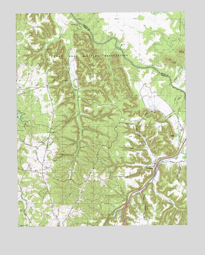
Colesburg, KY USGS Topographic Map
Click on map above to begin viewing in our Map Viewer.

This topographic map contains these locations and features:
Feature Name Type Latitude Longitude GNIS ID View Map
Atcher CemeteryCemeteryN37.8326°W85.8611°486110View Map
Bewley RunStreamN37.7702°W85.8723°2742503View Map
Bolton KnobSummitN37.8515°W85.7514°487645View Map
BoothPopulated PlaceN37.8053°W85.7516°507555View Map
Bowling CemeteryCemeteryN37.8537°W85.8530°487741View Map
Brewer HollowValleyN37.7956°W85.7788°487865View Map
Broad RunStreamN37.7676°W85.7916°487932View Map
Brown BranchStreamN37.7778°W85.7752°487986View Map
Bryan FlatsFlatN37.8101°W85.7546°2742505View Map
Cedar CreekStreamN37.8692°W85.8280°489176View Map
Cedar Creek CemeteryCemeteryN37.8434°W85.8366°489185View Map
ColesburgPopulated PlaceN37.7848°W85.7738°489834View Map
CrestPopulated PlaceN37.7501°W85.8436°507780View Map
Crooked CreekStreamN37.8428°W85.7747°490379View Map
Daugherty CemeteryCemeteryN37.8551°W85.7975°490607View Map
French CemeteryCemeteryN37.8417°W85.8602°492518View Map
French CemeteryCemeteryN37.8456°W85.8683°492519View Map
Happy HollowValleyN37.7951°W85.7802°493702View Map
Harned FlatsFlatN37.8510°W85.7880°2742430View Map
Hays FlatsFlatN37.8703°W85.7994°493937View Map
Larkin CemeteryCemeteryN37.7898°W85.7991°495990View Map
Maffet CemeteryCemeteryN37.7762°W85.8727°497446View Map
Maple HollowValleyN37.7701°W85.7841°497512View Map
McMillen CemeteryCemeteryN37.7853°W85.8555°497928View Map
Mud CreekStreamN37.7915°W85.7502°498980View Map
Mud RunStreamN37.8670°W85.7504°499016View Map
Orms KnobSummitN37.8471°W85.7634°499997View Map
Patterson Chapel CemeteryCemeteryN37.8676°W85.8633°500257View Map
Patty BranchStreamN37.7865°W85.7708°500270View Map
Poplar FlatsFlatN37.7523°W85.8008°509536View Map
Potlick PointCliffN37.8003°W85.7594°501193View Map
Rough RunStreamN37.7553°W85.8116°502394View Map
Saint Clare ChurchChurchN37.7842°W85.7744°509534View Map
Stader CemeteryCemeteryN37.7917°W85.7866°504219View Map
Stark KnobSummitN37.8456°W85.7594°504270View Map
Sulphur BranchStreamN37.7628°W85.7944°504727View Map
Sycamore CemeteryCemeteryN37.8712°W85.8252°504870View Map
Sycamore ChurchChurchN37.7992°W85.8552°504873View Map
Upper Douglas LakeReservoirN37.8145°W85.8727°509537View Map
Williams CemeteryCemeteryN37.8356°W85.8363°506808View Map
Wooldridge Ferry BridgeBridgeN37.8690°W85.8280°509879View Map

Note: Coordinates in the location and feature list above are referenced to NAD83 datum.


Copyright (C) 2008-2025 Ryan Niemi / Sunset Dynamics ... All Rights Reserved