TopoQuest Logo
Do you find TopoQuest useful?
Help keep TopoQuest running and adding new maps/features by donating!
Bitcoin:  19c7KJd3qBynnjoSw5npx9KScwjBe4ifkT
Litecoin:  LXs6TkuXGGXo1vDsWCkWVdjQX94eUKd6ui
Home View Maps Find Maps Find Places Resources & Links


Colton, New York Topographic Map

USGS Map Title: Colton, NY
USGS Map MRC: 44074E8
DRG (GeoTIFF) Download: o44074e8.tif


Neighboring USGS Topographic Map Quads:


  West Potsdam, NY  
44075F1
 

  Potsdam, NY  
44074F8
 

  Parishville, NY  
44074F7
 

  Pierrepont, NY  
44075E1
 

  Colton, NY  
44074E8
 

  Rainbow Falls, NY  
44074E7
 

  West Pierrepont, NY  
44075D1
 

  Albert Marsh, NY  
44074D8
 

  Stark, NY  
44074D7


Map MRC Location:

N45°
W75°
N45°
W74°
H8 H7 H6 H5 H4 H3 H2 H1
G8 G7 G6 G5 G4 G3 G2 G1
F8 F7 F6 F5 F4 F3 F2 F1
E8 E7 E6 E5 E4 E3 E2 E1
D8 D7 D6 D5 D4 D3 D2 D1
C8 C7 C6 C5 C4 C3 C2 C1
B8 B7 B6 B5 B4 B3 B2 B1
A8 A7 A6 A5 A4 A3 A2 A1
N44°
W75°
N44°
W74°

Colton, NY USGS 1:24K Topographic Map Preview:
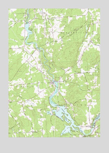
Colton, NY USGS Topographic Map
Click on map above to begin viewing in our Map Viewer.

This topographic map contains these locations and features:
Feature Name Type Latitude Longitude GNIS ID View Map
Arbuckle PondLakeN44.5162°W74.9201°975899View Map
Browns BridgeLocaleN44.5862°W74.9608°976039View Map
Central SchoolSchoolN44.5578°W74.9474°976105View Map
Cold BrookStreamN44.5028°W74.8905°975870View Map
ColtonPopulated PlaceN44.5531°W74.9396°976169View Map
Colton Census Designated PlaceCensusN44.5593°W74.9433°2627943View Map
Colton Hepburn LibraryBuildingN44.5530°W74.9389°2598310View Map
Colton Post OfficePost OfficeN44.5537°W74.9410°2599000View Map
Colton United Methodist ChurchChurchN44.6123°W74.9704°2599223View Map
Colton Volunteer Fire Department Company 1BuildingN44.5548°W74.9381°2735271View Map
Colton Volunteer Fire Department Company 2BuildingN44.5100°W74.8819°2735272View Map
Colton Wesleyan ChurchChurchN44.5547°W74.9413°2597589View Map
Coney IslandPopulated PlaceN44.6062°W74.9716°976172View Map
Cooks CemeteryCemeteryN44.5045°W74.9739°976179View Map
Green PondLakeN44.5234°W74.9446°976373View Map
Hannawa FallsPopulated PlaceN44.6123°W74.9710°976407View Map
Hannawa Falls Census Designated PlaceCensusN44.6017°W74.9738°2627947View Map
Hannawa Falls Fire DepartmentBuildingN44.6114°W74.9755°2718554View Map
Hannawa Falls Post OfficePost OfficeN44.6130°W74.9683°2599005View Map
High FlatsPopulated PlaceN44.5934°W74.8888°976435View Map
Higley FallsFallsN44.5306°W74.9319°976438View Map
Little Cold BrookStreamN44.5017°W74.8980°977233View Map
O'Malley BrookStreamN44.5742°W74.9460°976749View Map
Pleasant Mound CemeteryCemeteryN44.5586°W74.9284°976836View Map
Postwood ParkParkN44.6017°W74.9660°976852View Map
Riverside CemeteryCemeteryN44.5950°W74.9774°976893View Map
Russell CemeteryCemeteryN44.5073°W74.9134°976918View Map
Saint Lawrence State Forest Number 12ForestN44.5023°W74.9066°976931View Map
Saint Lawrence State Forest Number 28ForestN44.6003°W74.9091°976934View Map
Saint Patrick CemeteryCemeteryN44.5538°W74.9267°976951View Map
Saint Patrick ChurchChurchN44.5542°W74.9327°976953View Map
School Number 1 (historical)SchoolN44.5789°W74.9686°2106411View Map
School Number 10 (historical)SchoolN44.5317°W74.9803°2106418View Map
School Number 12 (historical)SchoolN44.5517°W74.9669°2106419View Map
School Number 14 (historical)SchoolN44.5928°W74.8886°2106420View Map
School Number 15 (historical)SchoolN44.5053°W74.9675°2106422View Map
School Number 2 (historical)SchoolN44.5089°W74.8872°2106412View Map
School Number 4 (historical)SchoolN44.5628°W74.8975°2106413View Map
School Number 5 (historical)SchoolN44.5942°W74.9333°2106414View Map
School Number 6 (historical)SchoolN44.5328°W74.9153°2106415View Map
School Number 7 (historical)SchoolN44.5222°W74.9386°2106416View Map
School Number 7 (historical)SchoolN44.6147°W74.9461°2106417View Map
South ColtonPopulated PlaceN44.5106°W74.8877°977030View Map
Three FallsFallsN44.5167°W74.8819°2106410View Map
Vebber CornersLocaleN44.5053°W74.9671°977170View Map
Warm BrookStreamN44.5015°W74.9285°977182View Map
Warm Brook FlowLakeN44.5066°W74.9225°977183View Map
Washburn CornersLocaleN44.5353°W74.9983°977185View Map
West ParishvillePopulated PlaceN44.6151°W74.9460°977255View Map
WildwoodPopulated PlaceN44.5626°W74.9008°977275View Map
WillisvillePopulated PlaceN44.5934°W74.9383°977280View Map
Willisville CemeteryCemeteryN44.5891°W74.9520°977281View Map
Wilson CornersLocaleN44.5045°W74.9855°977283View Map
Zion Episcopal ChurchChurchN44.5494°W74.9445°2598308View Map

Note: Coordinates in the location and feature list above are referenced to NAD83 datum.


Copyright (C) 2008-2024 Ryan Niemi / Sunset Dynamics ... All Rights Reserved