TopoQuest Logo
Do you find TopoQuest useful?
Help keep TopoQuest running and adding new maps/features by donating!
Bitcoin:  19c7KJd3qBynnjoSw5npx9KScwjBe4ifkT
Litecoin:  LXs6TkuXGGXo1vDsWCkWVdjQX94eUKd6ui
Home View Maps Find Maps Find Places Resources & Links


Concordia, Missouri Topographic Map

USGS Map Title: Concordia, MO
USGS Map MRC: 38093H5
DRG (GeoTIFF) Download: o38093h5.tif


Neighboring USGS Topographic Map Quads:


  Higginsville, MO  
39093A6
 

  Alma, MO  
39093A5
 

  Blackburn, MO  
39093A4
 

  Knob Noster NW, MO  
38093H6
 

  Concordia, MO  
38093H5
 

  Sweet Springs, MO  
38093H4
 

  Warrensburg East, MO  
38093G6
 

  Knob Noster, MO  
38093G5
 

  La Monte, MO  
38093G4


Map MRC Location:

N39°
W94°
N39°
W93°
H8 H7 H6 H5 H4 H3 H2 H1
G8 G7 G6 G5 G4 G3 G2 G1
F8 F7 F6 F5 F4 F3 F2 F1
E8 E7 E6 E5 E4 E3 E2 E1
D8 D7 D6 D5 D4 D3 D2 D1
C8 C7 C6 C5 C4 C3 C2 C1
B8 B7 B6 B5 B4 B3 B2 B1
A8 A7 A6 A5 A4 A3 A2 A1
N38°
W94°
N38°
W93°

Concordia, MO USGS 1:24K Topographic Map Preview:
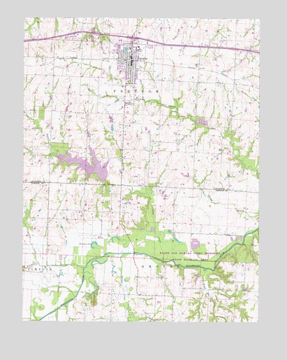
Concordia, MO USGS Topographic Map
Click on map above to begin viewing in our Map Viewer.

This topographic map contains these locations and features:
Feature Name Type Latitude Longitude GNIS ID View Map
Blackjack CreekStreamN38.8750°W93.6177°729707View Map
Brush CreekStreamN38.8970°W93.5288°729713View Map
City of ConcordiaCivilN38.9878°W93.5683°2393617View Map
ConcordiaPopulated PlaceN38.9833°W93.5685°716186View Map
Concordia Baptist CemeteryCemeteryN38.9642°W93.5677°717668View Map
Concordia Elementary SchoolSchoolN38.9854°W93.5771°2545198View Map
Concordia Fire Protection District Main StationBuildingN38.9814°W93.5675°2621225View Map
Concordia High SchoolSchoolN38.9775°W93.5707°2545408View Map
Concordia Police DepartmentBuildingN38.9824°W93.5685°2752186View Map
Concordia Post OfficePost OfficeN38.9821°W93.5674°2779549View Map
County Line School (historical)SchoolN38.9297°W93.5300°745499View Map
Edwin A Pape LakeReservoirN38.9391°W93.5912°762888View Map
Edwin A Pape Lake DamDamN38.9333°W93.5819°762887View Map
Eureka School (historical)SchoolN38.9734°W93.5133°734340View Map
Flagstaff CreekStreamN38.8972°W93.5933°717980View Map
Heimsoth Lake DamDamN38.9883°W93.5835°763542View Map
Horseshoe LakeLakeN38.9054°W93.5872°719867View Map
Lowland School (historical)SchoolN38.8786°W93.5460°745501View Map
Mulkey CreekStreamN38.8989°W93.6166°723055View Map
Oak Ridge School (historical)SchoolN38.9205°W93.5828°745498View Map
Opfer Lake DamDamN38.9567°W93.5785°763321View Map
Payne CemeteryCemeteryN38.8936°W93.5544°724117View Map
Peavine CreekStreamN38.9000°W93.5508°724156View Map
Ralph and Martha Perry Memorial State Wildlife AreaParkN38.9017°W93.5355°742786View Map
Saint Johns CemeteryCemeteryN38.9911°W93.5213°725775View Map
Saint Johns Evangelical Church (historical)ChurchN38.9897°W93.5208°747167View Map
Saint Paul Lutheran High SchoolSchoolN38.9882°W93.5645°2545336View Map
Saint Paul's Lutheran SchoolSchoolN38.9851°W93.5676°2545223View Map
Saint Pauls College (historical)SchoolN38.9875°W93.5666°725884View Map
Sunny Side School (historical)SchoolN38.8811°W93.5922°745500View Map
Township of FreedomCivilN38.9726°W93.6244°766873View Map
Walkenhorst School (historical)SchoolN38.9679°W93.5860°734339View Map
Walnut CreekStreamN38.9031°W93.5722°728299View Map
Werths Lake DamDamN38.9533°W93.5785°763322View Map

Note: Coordinates in the location and feature list above are referenced to NAD83 datum.


Copyright (C) 2008-2025 Ryan Niemi / Sunset Dynamics ... All Rights Reserved