TopoQuest Logo
Do you find TopoQuest useful?
Help keep TopoQuest running and adding new maps/features by donating!
Bitcoin:  19c7KJd3qBynnjoSw5npx9KScwjBe4ifkT
Litecoin:  LXs6TkuXGGXo1vDsWCkWVdjQX94eUKd6ui
Home View Maps Find Maps Find Places Resources & Links


Conejo Creek East, New Mexico Topographic Map

USGS Map Title: Conejo Creek East, NM
USGS Map MRC: 34104B3
DRG (GeoTIFF) Download: o34104b3.tif


Neighboring USGS Topographic Map Quads:


  West Camp, NM  
34104C4
 

  Alamo Ranch, NM  
34104C3
 

  Bonner Lake, NM  
34104C2
 

  Conejo Creek West, NM  
34104B4
 

  Conejo Creek East, NM  
34104B3
 

  Eighteenmile Hill, NM  
34104B2
 

  Lovelady Draw, NM  
34104A4
 

  La Espia Peak, NM  
34104A3
 

  Cooley Lake, NM  
34104A2


Map MRC Location:

N35°
W105°
N35°
W104°
H8 H7 H6 H5 H4 H3 H2 H1
G8 G7 G6 G5 G4 G3 G2 G1
F8 F7 F6 F5 F4 F3 F2 F1
E8 E7 E6 E5 E4 E3 E2 E1
D8 D7 D6 D5 D4 D3 D2 D1
C8 C7 C6 C5 C4 C3 C2 C1
B8 B7 B6 B5 B4 B3 B2 B1
A8 A7 A6 A5 A4 A3 A2 A1
N34°
W105°
N34°
W104°

Conejo Creek East, NM USGS 1:24K Topographic Map Preview:
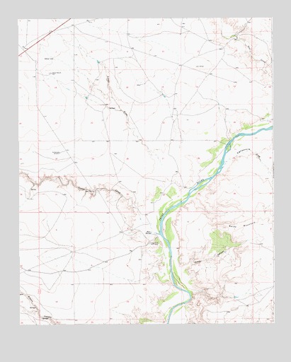
Conejo Creek East, NM USGS Topographic Map
Click on map above to begin viewing in our Map Viewer.

This topographic map contains these locations and features:
Feature Name Type Latitude Longitude GNIS ID View Map
10011 Water WellWellN34.2323°W104.3664°930902View Map
10015 Water WellWellN34.1920°W104.3728°930895View Map
10020 Water WellWellN34.2442°W104.2941°930904View Map
10021 Water WellWellN34.2373°W104.2750°931379View Map
10022 Water WellWellN34.2431°W104.2661°931381View Map
10023 Water WellWellN34.2431°W104.2674°930903View Map
10024 Water WellWellN34.2198°W104.3028°931386View Map
10025 Water WellWellN34.2228°W104.3154°930899View Map
10026 Water WellWellN34.2287°W104.3572°930901View Map
10027 Water WellWellN34.2104°W104.2980°931383View Map
10028 Water WellWellN34.1946°W104.3284°930896View Map
10029 Water WellWellN34.1952°W104.3549°930897View Map
10782 Water WellWellN34.1585°W104.2631°930894View Map
Alamo DrawValleyN34.1887°W104.3033°896890View Map
Baldy MountainSummitN34.1617°W104.2683°898720View Map
Blanco Spring Number 2SpringN34.1278°W104.3609°902780View Map
Conejo CreekStreamN34.1617°W104.3058°923584View Map
Crane CanyonValleyN34.1451°W104.2964°896963View Map
Eighteenmile DrawValleyN34.1890°W104.2753°897000View Map
Horse Pasture WellWellN34.2277°W104.3585°897050View Map
Rattlesnake WindmillLocaleN34.1951°W104.3547°897180View Map
Shaw SpringSpringN34.1624°W104.3105°897216View Map
Trigg Ranch River CampLocaleN34.1579°W104.3108°897258View Map

Note: Coordinates in the location and feature list above are referenced to NAD83 datum.


Copyright (C) 2008-2025 Ryan Niemi / Sunset Dynamics ... All Rights Reserved