TopoQuest Logo
Do you find TopoQuest useful?
Help keep TopoQuest running and adding new maps/features by donating!
Bitcoin:  19c7KJd3qBynnjoSw5npx9KScwjBe4ifkT
Litecoin:  LXs6TkuXGGXo1vDsWCkWVdjQX94eUKd6ui
Home View Maps Find Maps Find Places Resources & Links


Rawhide Mountain, Arizona Topographic Map

USGS Map Title: Rawhide Mountain, AZ
USGS Map MRC: 33110A4
DRG (GeoTIFF) Download: o33110a4.tif


Neighboring USGS Topographic Map Quads:


  Coolidge Dam, AZ  
33110B5
 

  San Carlos Reservoir, AZ  
33110B4
 

  Dewey Flat, AZ  
33110B3
 

  Jerusalem Mountain, AZ  
33110A5
 

  Rawhide Mountain, AZ  
33110A4
 

  Mount Turnbull, AZ  
33110A3
 

  Brandenburg Mountain, AZ  
32110H5
 

  Booger Canyon, AZ  
32110H4
 

  Cobre Grande Mountain, AZ  
32110H3


Map MRC Location:

N34°
W111°
N34°
W110°
H8 H7 H6 H5 H4 H3 H2 H1
G8 G7 G6 G5 G4 G3 G2 G1
F8 F7 F6 F5 F4 F3 F2 F1
E8 E7 E6 E5 E4 E3 E2 E1
D8 D7 D6 D5 D4 D3 D2 D1
C8 C7 C6 C5 C4 C3 C2 C1
B8 B7 B6 B5 B4 B3 B2 B1
A8 A7 A6 A5 A4 A3 A2 A1
N33°
W111°
N33°
W110°

Rawhide Mountain, AZ USGS 1:24K Topographic Map Preview:
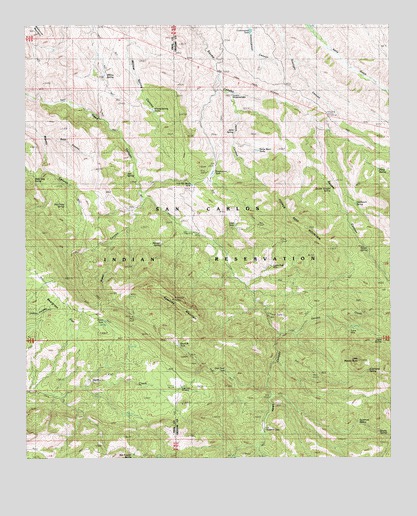
Rawhide Mountain, AZ USGS Topographic Map
Click on map above to begin viewing in our Map Viewer.

This topographic map contains these locations and features:
Feature Name Type Latitude Longitude GNIS ID View Map
Ash SpringSpringN33.0820°W110.4659°853View Map
Beargrass FlatFlatN33.0442°W110.4893°1157View Map
Bowman RanchLocaleN33.0615°W110.3859°1895View Map
Brushy SpringSpringN33.0073°W110.3770°2042View Map
Buck CanyonValleyN33.0928°W110.4937°2062View Map
Coal Field WindmillLocaleN33.0206°W110.4482°3048View Map
Copper Reef MineMineN33.0562°W110.4148°3243View Map
Copper Reef MountainSummitN33.0665°W110.4037°3244View Map
Davis SpringSpringN33.0340°W110.3787°3734View Map
Double Troughs SpringSpringN33.0779°W110.3960°4065View Map
Dry Camp SpringSpringN33.0731°W110.4870°4128View Map
Elderberry SpringSpringN33.0251°W110.3834°4393View Map
Friend MineMineN33.0362°W110.3898°4860View Map
Garden CreekStreamN33.0356°W110.4143°4936View Map
Horse Basin TanksReservoirN33.0889°W110.4213°5941View Map
Janis CanyonValleyN33.1045°W110.4301°6358View Map
Janis SpringSpringN33.0940°W110.4288°6359View Map
Lime TankReservoirN33.0677°W110.4286°42965View Map
Little Stanley ButteSummitN33.0281°W110.3865°7198View Map
Musk Hog SpringSpringN33.0809°W110.4979°8452View Map
Old Ranch SpringSpringN33.0734°W110.3873°8962View Map
Piņon SpringSpringN33.0826°W110.3798°9513View Map
Rawhide MountainSummitN33.0456°W110.4501°9994View Map
Red Rooster SpringSpringN33.0006°W110.4643°10143View Map
Sanders Rangeline CabinLocaleN33.1045°W110.4301°10914View Map
Squaw SpringSpringN33.0602°W110.3833°11751View Map
Sycamore SpringSpringN33.0103°W110.3868°12088View Map
U B Rangeline CabinLocaleN33.0078°W110.4187°13024View Map
Water CanyonValleyN33.0740°W110.4604°13376View Map
Webster SpringSpringN33.0617°W110.4543°13432View Map
Willow SpringSpringN33.1104°W110.4735°13843View Map

Note: Coordinates in the location and feature list above are referenced to NAD83 datum.


Copyright (C) 2008-2025 Ryan Niemi / Sunset Dynamics ... All Rights Reserved