TopoQuest Logo
Do you find TopoQuest useful?
Help keep TopoQuest running and adding new maps/features by donating!
Bitcoin:  19c7KJd3qBynnjoSw5npx9KScwjBe4ifkT
Litecoin:  LXs6TkuXGGXo1vDsWCkWVdjQX94eUKd6ui
Home View Maps Find Maps Find Places Resources & Links


Copeland, North Carolina Topographic Map

USGS Map Title: Copeland, NC
USGS Map MRC: 36080C6
DRG (GeoTIFF) Download: o36080c6.tif


Neighboring USGS Topographic Map Quads:


  Bottom, NC  
36080D7
 

  Dobson, NC  
36080D6
 

  Mount Airy South, NC  
36080D5
 

  Elkin North, NC  
36080C7
 

  Copeland, NC  
36080C6
 

  Siloam, NC  
36080C5
 

  Elkin South, NC  
36080B7
 

  Yadkinville, NC  
36080B6
 

  East Bend, NC  
36080B5


Map MRC Location:

N37°
W81°
N37°
W80°
H8 H7 H6 H5 H4 H3 H2 H1
G8 G7 G6 G5 G4 G3 G2 G1
F8 F7 F6 F5 F4 F3 F2 F1
E8 E7 E6 E5 E4 E3 E2 E1
D8 D7 D6 D5 D4 D3 D2 D1
C8 C7 C6 C5 C4 C3 C2 C1
B8 B7 B6 B5 B4 B3 B2 B1
A8 A7 A6 A5 A4 A3 A2 A1
N36°
W81°
N36°
W80°

Copeland, NC USGS 1:24K Topographic Map Preview:
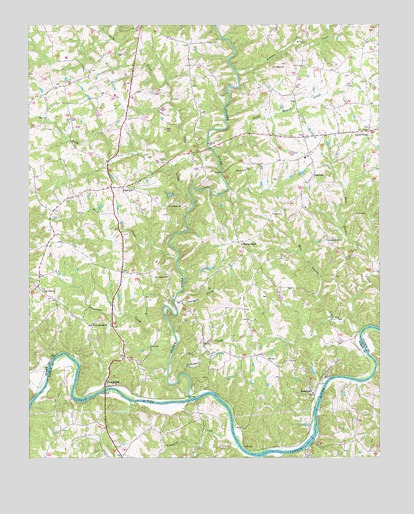
Copeland, NC USGS Topographic Map
Click on map above to begin viewing in our Map Viewer.

This topographic map contains these locations and features:
Feature Name Type Latitude Longitude GNIS ID View Map
Bear CreekStreamN36.3074°W80.6970°980708View Map
Bear Creek Baptist ChurchChurchN36.3235°W80.6965°980718View Map
Bear Creek CemeteryCemeteryN36.3240°W80.6953°1731530View Map
Beaver CreekStreamN36.3615°W80.6753°980797View Map
Blackwoods Bloomery Forge (historical)LocaleN36.3312°W80.6909°1731527View Map
C C Camp Volunteer Fire Department Station 65ABuildingN36.2990°W80.7470°2639509View Map
Cody CreekStreamN36.3249°W80.6917°983334View Map
Cody ParkParkN36.3679°W80.7159°1001973View Map
Combs Mill (historical)LocaleN36.2932°W80.6445°1731548View Map
CopelandPopulated PlaceN36.3385°W80.6501°983522View Map
Copeland Baptist ChurchChurchN36.3251°W80.6540°1731551View Map
Copeland Baptist Church CemeteryCemeteryN36.3255°W80.6531°1731552View Map
Copeland Elementary SchoolSchoolN36.3310°W80.6509°1001974View Map
Copeland High School (historical)SchoolN36.3368°W80.6509°1731553View Map
CrutchfieldPopulated PlaceN36.2707°W80.7226°1019877View Map
Davenport CreekStreamN36.2743°W80.6937°983967View Map
Double CreekStreamN36.2862°W80.6317°984283View Map
Double Creek CemeteryCemeteryN36.3129°W80.6437°1731557View Map
Double Creek ChurchChurchN36.3129°W80.6431°984287View Map
Dunagan CreekStreamN36.2918°W80.6967°984416View Map
East Double CreekStreamN36.2868°W80.6326°984493View Map
FairviewPopulated PlaceN36.3285°W80.7203°1020200View Map
Fairview Baptist ChurchChurchN36.3282°W80.7162°1731561View Map
Fairview WildlifeReservoirN36.3261°W80.6995°1000526View Map
Fairview Wildlife Club DamDamN36.3268°W80.6981°1000527View Map
Fall CreekStreamN36.2540°W80.6501°984975View Map
Fall Creek Mill (historical)LocaleN36.2535°W80.6498°1731733View Map
Fisher RiverStreamN36.2674°W80.6926°985104View Map
Holafields Bloomery Forge (historical)LocaleN36.3085°W80.6987°1731583View Map
Horns BranchStreamN36.3354°W80.7198°1731584View Map
Hyatts Forge Number 2 (historical)LocaleN36.3537°W80.6523°1731588View Map
John Dobson HomeParkN36.2776°W80.6340°1001985View Map
King CreekStreamN36.3343°W80.6987°987980View Map
Level CrossPopulated PlaceN36.3446°W80.6287°988369View Map
Level Cross United Methodist ChurchChurchN36.3449°W80.6292°1731598View Map
Liberty CemeteryCemeteryN36.3337°W80.6723°1731599View Map
Liberty Primitive Baptist ChurchChurchN36.3332°W80.6726°988421View Map
Little Beaver CreekStreamN36.3387°W80.6837°988535View Map
Mount Herman ChurchChurchN36.2890°W80.7265°990402View Map
Mount Pleasant ChurchChurchN36.3026°W80.7003°990555View Map
New Hope ChurchChurchN36.2987°W80.7448°991025View Map
New Hope ChurchChurchN36.3629°W80.6584°991028View Map
Pheasant CreekStreamN36.2810°W80.6984°992114View Map
RockfordPopulated PlaceN36.2685°W80.6487°993538View Map
Rockford Baptist ChurchChurchN36.2749°W80.6512°1731643View Map
Rockford CourthouseParkN36.2724°W80.6509°1002002View Map
Rockford Ferry (historical)CrossingN36.2601°W80.6476°1731644View Map
Rockford Historic DistrictParkN36.2696°W80.6492°1731645View Map
Rockford Methodist Church (historical)ChurchN36.2712°W80.6501°1731646View Map
Rockford School (historical)SchoolN36.2787°W80.6656°1731647View Map
Rutledge Bloomery Forge (historical)LocaleN36.3471°W80.6962°1731653View Map
South Surry Volunteer Fire Department Station 74BuildingN36.3104°W80.6731°2639243View Map
South Surry Volunteer Fire Department Station 74A HeadquartersBuildingN36.3455°W80.6287°2639346View Map
Stony KnollPopulated PlaceN36.3115°W80.6737°995574View Map
Stony Knoll CemeteryCemeteryN36.3121°W80.6742°1731670View Map
Stony Knoll Methodist ChurchChurchN36.3126°W80.6737°1731671View Map
Tanyard CreekStreamN36.2535°W80.6751°995844View Map
Township of RockfordCivilN36.3078°W80.6509°1027219View Map
West Double CreekStreamN36.2865°W80.6328°997005View Map
White Rock FordCrossingN36.2629°W80.6478°1731694View Map
Whiteoak BranchStreamN36.3710°W80.7203°1731695View Map
York TavernLocaleN36.2682°W80.6492°1002013View Map

Note: Coordinates in the location and feature list above are referenced to NAD83 datum.


Copyright (C) 2008-2025 Ryan Niemi / Sunset Dynamics ... All Rights Reserved