TopoQuest Logo
Do you find TopoQuest useful?
Help keep TopoQuest running and adding new maps/features by donating!
Bitcoin:  19c7KJd3qBynnjoSw5npx9KScwjBe4ifkT
Litecoin:  LXs6TkuXGGXo1vDsWCkWVdjQX94eUKd6ui
Home View Maps Find Maps Find Places Resources & Links


Bottom, North Carolina Topographic Map

USGS Map Title: Bottom, NC
USGS Map MRC: 36080D7
DRG (GeoTIFF) Download: o36080d7.tif


Neighboring USGS Topographic Map Quads:


  Cumberland Knob, NC  
36080E8
 

  Lambsburg, VA  
36080E7
 

  Cana, VA  
36080E6
 

  Roaring Gap, NC  
36080D8
 

  Bottom, NC  
36080D7
 

  Dobson, NC  
36080D6
 

  Thurmond, NC  
36080C8
 

  Elkin North, NC  
36080C7
 

  Copeland, NC  
36080C6


Map MRC Location:

N37°
W81°
N37°
W80°
H8 H7 H6 H5 H4 H3 H2 H1
G8 G7 G6 G5 G4 G3 G2 G1
F8 F7 F6 F5 F4 F3 F2 F1
E8 E7 E6 E5 E4 E3 E2 E1
D8 D7 D6 D5 D4 D3 D2 D1
C8 C7 C6 C5 C4 C3 C2 C1
B8 B7 B6 B5 B4 B3 B2 B1
A8 A7 A6 A5 A4 A3 A2 A1
N36°
W81°
N36°
W80°

Bottom, NC USGS 1:24K Topographic Map Preview:
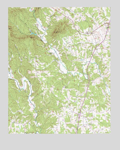
Bottom, NC USGS Topographic Map
Click on map above to begin viewing in our Map Viewer.

This topographic map contains these locations and features:
Feature Name Type Latitude Longitude GNIS ID View Map
BeulahPopulated PlaceN36.4749°W80.7740°1019265View Map
Beulah CemeteryCemeteryN36.4868°W80.7795°1731526View Map
Beulah Elementary SchoolSchoolN36.4749°W80.7781°1024807View Map
Beulah Methodist ChurchChurchN36.4868°W80.7795°981280View Map
Blevins StoreLocaleN36.4546°W80.8201°981594View Map
Bottom Post Office (historical)Post OfficeN36.4745°W80.7742°2708379View Map
Bryan School (historical)SchoolN36.3840°W80.8565°1731538View Map
Burris CreekStreamN36.4293°W80.7798°982305View Map
Camp Raven KnobLocaleN36.4765°W80.8481°982546View Map
Central Surry Volunteer Fire Department Station 77ABuildingN36.3983°W80.7892°2639084View Map
Central View ChurchChurchN36.4279°W80.7717°982973View Map
Charity Hill ChurchChurchN36.3862°W80.8667°983036View Map
Christian CreekStreamN36.4354°W80.8729°983171View Map
Chryson LakeReservoirN36.4535°W80.8748°1000647View Map
Chryson Lake DamDamN36.4535°W80.8748°1000646View Map
Cross Roads Baptist ChurchChurchN36.4210°W80.8059°983789View Map
Endicott CreekStreamN36.4707°W80.8331°984786View Map
Flat BranchStreamN36.4349°W80.8009°1731566View Map
Flat Top Primitive Baptist ChurchChurchN36.4571°W80.7731°985198View Map
Flattop CemeteryCemeteryN36.4571°W80.7737°1731570View Map
Fulcher MountainSummitN36.4994°W80.8385°1020378View Map
Hatchers CreekStreamN36.4646°W80.7598°986489View Map
Holy Cross Missionary Baptist ChurchChurchN36.4700°W80.7651°2710101View Map
Jadesville (historical)LocaleN36.4396°W80.8192°1001984View Map
Kapps MillLocaleN36.3971°W80.8309°1001986View Map
LadoniaPopulated PlaceN36.4824°W80.8379°1006269View Map
Ladonia Baptist ChurchChurchN36.4776°W80.8381°1731597View Map
Little Endicott CreekStreamN36.4749°W80.8456°988634View Map
Little Vine Church (historical)ChurchN36.3968°W80.7506°1731603View Map
McMickle School (historical)SchoolN36.4443°W80.8323°1731607View Map
Mill CreekStreamN36.3879°W80.8406°989957View Map
Mitchell River Baptist Church (historical)ChurchN36.3935°W80.8423°1731608View Map
Mountain Park CemeteryCemeteryN36.3771°W80.8548°1731616View Map
Muddy ForkStreamN36.4040°W80.8284°990764View Map
New Bethel Baptist ChurchChurchN36.4504°W80.8423°990942View Map
New Hope ChurchChurchN36.4407°W80.7540°991031View Map
New Life Baptist ChurchChurchN36.4521°W80.8028°991061View Map
Oak GrovePopulated PlaceN36.4837°W80.7567°1731627View Map
Oak Grove Baptist ChurchChurchN36.4793°W80.7542°991407View Map
Pine BranchStreamN36.3974°W80.8409°992228View Map
Potters CreekStreamN36.4296°W80.8520°992752View Map
Raven KnobSummitN36.4699°W80.8448°993065View Map
Raven Knob Park LakeReservoirN36.4744°W80.8439°1000667View Map
Raven Knob Park Lake DamDamN36.4735°W80.8398°1000666View Map
Red Hill CreekStreamN36.4460°W80.8112°993122View Map
Rocky Ford CemeteryCemeteryN36.4162°W80.8520°1731649View Map
Rocky Ford Missionary Baptist ChurchChurchN36.4165°W80.8526°993589View Map
Round Peak Tree FarmLocaleN36.4731°W80.8358°2677956View Map
Rusk (historical)LocaleN36.3971°W80.8040°1002003View Map
Sage CreekStreamN36.4771°W80.8295°993847View Map
Salem Fork Baptist ChurchChurchN36.3951°W80.7895°994184View Map
Salem Fork CemeteryCemeteryN36.3840°W80.7762°994183View Map
SalemforkPopulated PlaceN36.3946°W80.7870°1731654View Map
Skull Camp MountainSummitN36.4754°W80.8165°994886View Map
Skull Camp Volunteer Fire Department Station 72 HeadquartersBuildingN36.4994°W80.8212°2638914View Map
Township of FranklinCivilN36.4991°W80.8561°1027214View Map
Warrior MountainSummitN36.4710°W80.8748°1002008View Map
Wood ForkStreamN36.4776°W80.7637°997566View Map

Note: Coordinates in the location and feature list above are referenced to NAD83 datum.


Copyright (C) 2008-2025 Ryan Niemi / Sunset Dynamics ... All Rights Reserved