TopoQuest Logo
Do you find TopoQuest useful?
Help keep TopoQuest running and adding new maps/features by donating!
Bitcoin:  19c7KJd3qBynnjoSw5npx9KScwjBe4ifkT
Litecoin:  LXs6TkuXGGXo1vDsWCkWVdjQX94eUKd6ui
Home View Maps Find Maps Find Places Resources & Links


Elkin North, North Carolina Topographic Map

USGS Map Title: Elkin North, NC
USGS Map MRC: 36080C7
DRG (GeoTIFF) Download: o36080c7.tif


Neighboring USGS Topographic Map Quads:


  Roaring Gap, NC  
36080D8
 

  Bottom, NC  
36080D7
 

  Dobson, NC  
36080D6
 

  Thurmond, NC  
36080C8
 

  Elkin North, NC  
36080C7
 

  Copeland, NC  
36080C6
 

  Ronda, NC  
36080B8
 

  Elkin South, NC  
36080B7
 

  Yadkinville, NC  
36080B6


Map MRC Location:

N37°
W81°
N37°
W80°
H8 H7 H6 H5 H4 H3 H2 H1
G8 G7 G6 G5 G4 G3 G2 G1
F8 F7 F6 F5 F4 F3 F2 F1
E8 E7 E6 E5 E4 E3 E2 E1
D8 D7 D6 D5 D4 D3 D2 D1
C8 C7 C6 C5 C4 C3 C2 C1
B8 B7 B6 B5 B4 B3 B2 B1
A8 A7 A6 A5 A4 A3 A2 A1
N36°
W81°
N36°
W80°

Elkin North, NC USGS 1:24K Topographic Map Preview:
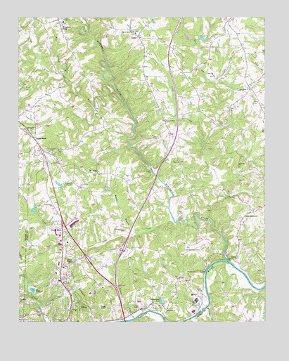
Elkin North, NC USGS Topographic Map
Click on map above to begin viewing in our Map Viewer.

This topographic map contains these locations and features:
Feature Name Type Latitude Longitude GNIS ID View Map
Allens Iron Works (historical)LocaleN36.2507°W80.8620°1731514View Map
Bakers Mill (historical)LocaleN36.3299°W80.7726°1731518View Map
Bessies Chapel Baptist ChurchChurchN36.3326°W80.8001°981055View Map
Bessies Chapel CemeteryCemeteryN36.3329°W80.8003°1731525View Map
Bradley Mill (historical)LocaleN36.3071°W80.7701°1731534View Map
Brendle BranchStreamN36.2885°W80.8165°981851View Map
BurchPopulated PlaceN36.2760°W80.7665°982267View Map
Camp CreekStreamN36.2907°W80.7953°982521View Map
Cc Camp Volunteer Fire DepartmentBuildingN36.2825°W80.7762°2638788View Map
Cedarbrook Country ClubLocaleN36.3074°W80.8492°982906View Map
Cedarbrook LakeReservoirN36.3068°W80.8544°1000492View Map
Cedarbrook Lake DamDamN36.3051°W80.8531°1000493View Map
Crestwood Memorial ParkParkN36.3151°W80.8592°983742View Map
Elkin Municipal AirportAirportN36.2804°W80.7890°998056View Map
Elkin QuarryMineN36.2592°W80.8139°2648491View Map
Elkin Rescue SquadBuildingN36.2600°W80.8478°2720531View Map
Elkin ReservoirReservoirN36.2632°W80.8676°984713View Map
Elkin ValleyPopulated PlaceN36.2732°W80.8531°1020129View Map
Elkin Valley ChurchChurchN36.2735°W80.8520°1731559View Map
Flat BranchStreamN36.3537°W80.8540°985157View Map
Friendship Baptist ChurchChurchN36.2679°W80.7945°985458View Map
Friendship CemeteryCemeteryN36.2682°W80.7953°1731572View Map
Full Gospel ChurchChurchN36.2549°W80.8001°985492View Map
Grassy CreekStreamN36.2765°W80.8740°985954View Map
Grassy Creek CemeteryCemeteryN36.2976°W80.8578°1731575View Map
Grassy Creek Methodist ChurchChurchN36.2982°W80.8578°985957View Map
Gum Orchard Baptist ChurchChurchN36.3693°W80.8173°986223View Map
Holyfield LakeReservoirN36.3663°W80.7813°1000552View Map
Holyfield Lake DamDamN36.3668°W80.7831°1000553View Map
Hugh Chatham Memorial HospitalHospitalN36.2622°W80.8386°1731586View Map
Jot - Um - Down Volunteer Fire DepartmentBuildingN36.3342°W80.7794°2638314View Map
Lineberry CreekStreamN36.2521°W80.7853°988511View Map
Little CreekStreamN36.3235°W80.7803°988612View Map
Little RichmondPopulated PlaceN36.2949°W80.7576°988748View Map
Little Richmond Baptist ChurchChurchN36.2943°W80.7584°1731601View Map
Little Richmond CemeteryCemeteryN36.2948°W80.7578°1731602View Map
Mitchell RiverStreamN36.2754°W80.7695°990099View Map
Mount Pleasant Baptist ChurchChurchN36.3287°W80.8684°990556View Map
Mount Pleasant CemeteryCemeteryN36.3287°W80.8670°1731613View Map
Mountain ParkPopulated PlaceN36.3743°W80.8548°1021572View Map
Mountain Park Baptist ChurchChurchN36.3746°W80.8542°1731615View Map
Mountain Park Elementary SchoolSchoolN36.3729°W80.8545°1001990View Map
Mountain Park Institute (historical)SchoolN36.3729°W80.8520°1731617View Map
Mountain Park Methodist ChurchChurchN36.3701°W80.8531°1731618View Map
Mountain Park Rescue Squad and Fire StationBuildingN36.3745°W80.8524°2639814View Map
MulberryPopulated PlaceN36.3271°W80.8028°1731620View Map
Mulberry CemeteryCemeteryN36.3257°W80.8045°1731621View Map
Mulberry Primitive Baptist ChurchChurchN36.3260°W80.8051°990775View Map
North ElkinPopulated PlaceN36.2885°W80.8528°1021664View Map
North Elkin Elementary SchoolSchoolN36.2615°W80.8503°1001991View Map
Oak Grove CemeteryCemeteryN36.2796°W80.8201°991354View Map
Open Door CemeteryCemeteryN36.3137°W80.7628°1731630View Map
Open Door Missionary Baptist ChurchChurchN36.3143°W80.7634°991667View Map
Poplar SpringsPopulated PlaceN36.3112°W80.8326°1731639View Map
Poplar Springs ChurchChurchN36.3112°W80.8356°992713View Map
Rusk (historical)Populated PlaceN36.2899°W80.7623°1731652View Map
Snow CreekStreamN36.2876°W80.7740°995063View Map
Snow Hill Baptist ChurchChurchN36.3512°W80.7756°995071View Map
Snow Hill CemeteryCemeteryN36.3510°W80.7759°1731668View Map
South Fork Mitchell RiverStreamN36.3376°W80.8195°995156View Map
State RoadPopulated PlaceN36.3260°W80.8676°995434View Map
State Road Post OfficePost OfficeN36.3162°W80.8617°2774162View Map
Surry County Emergency Services Station 3BuildingN36.2601°W80.8478°2720481View Map
Town of ElkinCivilN36.2619°W80.8443°2406436View Map
Township of ElkinCivilN36.2852°W80.8304°1027213View Map
Township of MarshCivilN36.3055°W80.7507°1027216View Map
Turkey CreekStreamN36.2515°W80.8165°996323View Map
Union CrossPopulated PlaceN36.3460°W80.7573°1731678View Map
Union Cross Baptist ChurchChurchN36.3454°W80.7573°996470View Map
Union Cross CemeteryCemeteryN36.3451°W80.7570°1731679View Map
Valley ChurchChurchN36.3160°W80.7937°996574View Map
Williams CreekStreamN36.2560°W80.7798°997380View Map
Williams PondReservoirN36.2551°W80.7581°1000425View Map
Williams Pond DamDamN36.2551°W80.7581°1000426View Map
Willowbrook LakeReservoirN36.2585°W80.8027°997427View Map
Wood BranchStreamN36.3510°W80.8573°997562View Map
ZephyrPopulated PlaceN36.3676°W80.8142°997748View Map
Zephyr CemeteryCemeteryN36.3671°W80.8142°1731701View Map
Zephyr School (historical)SchoolN36.3687°W80.8153°1731702View Map

Note: Coordinates in the location and feature list above are referenced to NAD83 datum.


Copyright (C) 2008-2024 Ryan Niemi / Sunset Dynamics ... All Rights Reserved