TopoQuest Logo
Do you find TopoQuest useful?
Help keep TopoQuest running and adding new maps/features by donating!
Bitcoin:  19c7KJd3qBynnjoSw5npx9KScwjBe4ifkT
Litecoin:  LXs6TkuXGGXo1vDsWCkWVdjQX94eUKd6ui
Home View Maps Find Maps Find Places Resources & Links


Cordova, Alabama Topographic Map

USGS Map Title: Cordova, AL
USGS Map MRC: 33087G2
DRG (GeoTIFF) Download: o33087g2.tif


Neighboring USGS Topographic Map Quads:


  Manchester, AL  
33087H3
 

  Sunlight, AL  
33087H2
 

  Cold Springs, AL  
33087H1
 

  Jasper, AL  
33087G3
 

  Cordova, AL  
33087G2
 

  Sipsey, AL  
33087G1
 

  Parrish, AL  
33087F3
 

  Goodsprings, AL  
33087F2
 

  Dora, AL  
33087F1


Map MRC Location:

N34°
W88°
N34°
W87°
H8 H7 H6 H5 H4 H3 H2 H1
G8 G7 G6 G5 G4 G3 G2 G1
F8 F7 F6 F5 F4 F3 F2 F1
E8 E7 E6 E5 E4 E3 E2 E1
D8 D7 D6 D5 D4 D3 D2 D1
C8 C7 C6 C5 C4 C3 C2 C1
B8 B7 B6 B5 B4 B3 B2 B1
A8 A7 A6 A5 A4 A3 A2 A1
N33°
W88°
N33°
W87°

Cordova, AL USGS 1:24K Topographic Map Preview:
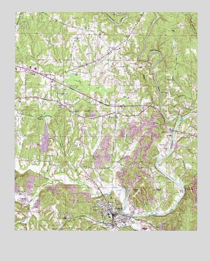
Cordova, AL USGS Topographic Map
Click on map above to begin viewing in our Map Viewer.

This topographic map contains these locations and features:
Feature Name Type Latitude Longitude GNIS ID View Map
Alma (historical)LocaleN33.8023°W87.2178°142265View Map
Argo ChurchChurchN33.8076°W87.1333°163880View Map
Baltimore School (historical)SchoolN33.7859°W87.1586°113435View Map
Bankhead Middle SchoolSchoolN33.7554°W87.1767°165353View Map
Banks School (historical)SchoolN33.8365°W87.1422°113451View Map
Barton BendBendN33.7876°W87.1525°151670View Map
Barton Grove ChurchChurchN33.8290°W87.1453°113529View Map
Bartons ChapelChurchN33.7737°W87.1500°113534View Map
Bartons Ferry (historical)CrossingN33.7768°W87.1381°151552View Map
Bates CreekStreamN33.7834°W87.2475°113563View Map
Beards MineMineN33.7598°W87.1917°135966View Map
BenoitPopulated PlaceN33.7540°W87.1572°113930View Map
Benoit BendBendN33.7548°W87.1689°151676View Map
Blackwater CreekStreamN33.8146°W87.1361°159197View Map
Blue BranchStreamN33.7821°W87.2300°114530View Map
BoldoPopulated PlaceN33.8540°W87.1828°114684View Map
Boldo CemeteryCemeteryN33.8498°W87.1858°142280View Map
Boldo Junior High School (historical)SchoolN33.8521°W87.1839°142282View Map
Boldo Methodist ChurchChurchN33.8501°W87.1853°142281View Map
Boldo Volunteer Fire and RescueBuildingN33.8524°W87.1842°2683415View Map
Broom MineMineN33.7679°W87.1903°135965View Map
Bullbarn CreekStreamN33.7782°W87.2244°115187View Map
Cane CreekStreamN33.7590°W87.1689°151716View Map
Chapel HillPopulated PlaceN33.8173°W87.2103°115952View Map
City of CordovaCivilN33.7613°W87.1926°2404130View Map
CordovaPopulated PlaceN33.7598°W87.1833°116626View Map
Cordova ChurchChurchN33.7732°W87.1536°142311View Map
Cordova Elementary SchoolSchoolN33.7621°W87.1861°142312View Map
Cordova High SchoolSchoolN33.7662°W87.1856°142313View Map
Cordova MineMineN33.7709°W87.2319°135970View Map
Cordova Number 1 MineMineN33.7834°W87.2153°135969View Map
Cordova Police DepartmentBuildingN33.7589°W87.1828°2752055View Map
Cordova Post OfficePost OfficeN33.7600°W87.1828°166855View Map
Cordova Volunteer Fire DepartmentBuildingN33.7545°W87.1834°2682859View Map
CorinthPopulated PlaceN33.7851°W87.2033°116628View Map
Corinth Baptist ChurchChurchN33.7854°W87.2031°142314View Map
Crossville Post Office (historical)Post OfficeN33.8009°W87.1292°166140View Map
Depot (historical)LocaleN33.7546°W87.1833°142319View Map
Disney Drift MineMineN33.7668°W87.1792°135963View Map
Evans CreekStreamN33.7712°W87.1850°118070View Map
Flat BranchStreamN33.7823°W87.2331°118361View Map
Flat Branch School (historical)SchoolN33.8148°W87.2306°142343View Map
Frog Ague CreekStreamN33.7557°W87.1717°118725View Map
Gardiners GinPopulated PlaceN33.8148°W87.2019°118827View Map
Gobblers CrossingPopulated PlaceN33.7509°W87.2181°119075View Map
Gode BranchStreamN33.8426°W87.2161°119078View Map
Hay Valley Volunteer Fire DepartmentBuildingN33.7560°W87.2418°2683425View Map
Hudson-Kirby StadiumParkN33.7664°W87.1847°2352836View Map
Hunters ChapelChurchN33.7918°W87.2278°142367View Map
Hunters School (historical)SchoolN33.7929°W87.2281°120558View Map
Jasper SpeedwayLocaleN33.8021°W87.2397°142375View Map
Liberty Church of ChristChurchN33.8607°W87.2086°152044View Map
Little Blackwater CreekStreamN33.8165°W87.1386°159956View Map
Long Memorial Methodist Episcopal Church (historical)ChurchN33.7568°W87.1817°142389View Map
Lynns ParkPopulated PlaceN33.8062°W87.1439°152178View Map
Madison Mobile Home ParkPopulated PlaceN33.7972°W87.2044°2514495View Map
Mount Carmel CemeteryCemeteryN33.7518°W87.1844°123166View Map
Mount Harmony Church of ChristChurchN33.8284°W87.2167°152420View Map
Mount HopePopulated PlaceN33.7693°W87.2411°123224View Map
Mount Hope ChurchChurchN33.7715°W87.2458°123225View Map
New Bethel ChurchChurchN33.8193°W87.1631°157380View Map
New Canaan Baptist ChurchChurchN33.8729°W87.2458°142399View Map
Oak Hill Mobile Home ParkPopulated PlaceN33.8317°W87.2222°2514496View Map
Oak Leaf MineMineN33.7634°W87.1764°135964View Map
Old Mount Carmel Baptist ChurchChurchN33.7523°W87.1842°142408View Map
Pine Grove ChurchChurchN33.8443°W87.2053°124800View Map
Pine Tree Trailer ParkPopulated PlaceN33.8239°W87.1667°2514497View Map
Poley CreekStreamN33.8226°W87.1506°125102View Map
Porter CemeteryCemeteryN33.8587°W87.1725°163909View Map
Red RockPopulated PlaceN33.8682°W87.1667°157388View Map
Reservoir HillSummitN33.7618°W87.1967°125572View Map
Rice MineMineN33.7932°W87.2333°135971View Map
Riceston HillSummitN33.7721°W87.1658°125599View Map
Riceton Number 5 MineMineN33.7876°W87.1708°135962View Map
Riverside ChurchChurchN33.7990°W87.1464°157389View Map
Riverside MineMineN33.7751°W87.1333°135960View Map
Saint James Methodist Episcopal ChurchChurchN33.7540°W87.1817°157392View Map
Samaria Baptist ChurchChurchN33.8148°W87.2314°153309View Map
Samaria CemeteryCemeteryN33.8159°W87.2319°142426View Map
Samoset MineMineN33.7515°W87.1458°135961View Map
Sanders ShoalsBarN33.8076°W87.1397°142427View Map
Sanderson Ferry (historical)CrossingN33.8062°W87.1431°154222View Map
SardisPopulated PlaceN33.7968°W87.1489°126400View Map
Sardis CemeteryCemeteryN33.7993°W87.1472°126403View Map
Sims PondsLakeN33.8396°W87.2101°126892View Map
Spokage CreekStreamN33.7759°W87.2067°153521View Map
Standard BranchStreamN33.7676°W87.2372°127299View Map
Stovatt BendBendN33.7726°W87.1344°153587View Map
Sulphur Springs MineMineN33.7543°W87.1978°135967View Map
Taft MineMineN33.7668°W87.1986°135968View Map
The PinnaclePillarN33.7742°W87.1323°127836View Map
Union ChapelPopulated PlaceN33.8168°W87.1778°128274View Map
Union Chapel CemeteryCemeteryN33.8159°W87.1811°128275View Map
Union Chapel ChurchChurchN33.8162°W87.1814°142451View Map
Union Chapel Junior High SchoolSchoolN33.8154°W87.1847°142452View Map
Uptain Mobile Home ParkPopulated PlaceN33.8567°W87.2025°2514498View Map
Valley View ChurchChurchN33.7621°W87.2392°142456View Map
Walker Baptist Medical CenterHospitalN33.8427°W87.2360°157400View Map
Walker County LakeReservoirN33.8016°W87.2293°128517View Map
Walker County Public Lake DamDamN33.7968°W87.2300°131748View Map
Watts CreekStreamN33.7748°W87.1828°128649View Map
Wesley ChurchChurchN33.8398°W87.2361°128748View Map

Note: Coordinates in the location and feature list above are referenced to NAD83 datum.


Copyright (C) 2008-2025 Ryan Niemi / Sunset Dynamics ... All Rights Reserved