TopoQuest Logo
Do you find TopoQuest useful?
Help keep TopoQuest running and adding new maps/features by donating!
Bitcoin:  19c7KJd3qBynnjoSw5npx9KScwjBe4ifkT
Litecoin:  LXs6TkuXGGXo1vDsWCkWVdjQX94eUKd6ui
Home View Maps Find Maps Find Places Resources & Links


Sunlight, Alabama Topographic Map

USGS Map Title: Sunlight, AL
USGS Map MRC: 33087H2
DRG (GeoTIFF) Download: o33087h2.tif


Neighboring USGS Topographic Map Quads:


  Black Pond, AL  
34087A3
 

  Arley, AL  
34087A2
 

  Crane Hill, AL  
34087A1
 

  Manchester, AL  
33087H3
 

  Sunlight, AL  
33087H2
 

  Cold Springs, AL  
33087H1
 

  Jasper, AL  
33087G3
 

  Cordova, AL  
33087G2
 

  Sipsey, AL  
33087G1


Map MRC Location:

N34°
W88°
N34°
W87°
H8 H7 H6 H5 H4 H3 H2 H1
G8 G7 G6 G5 G4 G3 G2 G1
F8 F7 F6 F5 F4 F3 F2 F1
E8 E7 E6 E5 E4 E3 E2 E1
D8 D7 D6 D5 D4 D3 D2 D1
C8 C7 C6 C5 C4 C3 C2 C1
B8 B7 B6 B5 B4 B3 B2 B1
A8 A7 A6 A5 A4 A3 A2 A1
N33°
W88°
N33°
W87°

Sunlight, AL USGS 1:24K Topographic Map Preview:
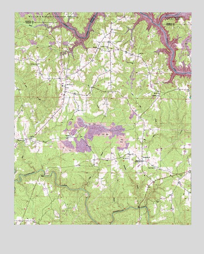
Sunlight, AL USGS Topographic Map
Click on map above to begin viewing in our Map Viewer.

This topographic map contains these locations and features:
Feature Name Type Latitude Longitude GNIS ID View Map
Aaron CemeteryCemeteryN33.8834°W87.1608°162295View Map
Battle BranchStreamN33.9934°W87.2161°159121View Map
Bear BranchStreamN33.9959°W87.1531°159127View Map
Blooming Grove Baptist ChurchChurchN33.9787°W87.1853°159201View Map
Blooming Grove CemeteryCemeteryN33.9704°W87.1658°159200View Map
Burrows CrossroadsPopulated PlaceN33.9129°W87.1600°159279View Map
Camp Jimmy GoodwinLocaleN33.9862°W87.2111°162303View Map
Camp O'RearLocaleN33.8993°W87.2400°162304View Map
CurryPopulated PlaceN33.9537°W87.2145°159474View Map
Curry ChurchChurchN33.9598°W87.2139°163887View Map
Curry Church of ChristChurchN33.9437°W87.2164°163888View Map
Curry Elementary SchoolSchoolN33.9584°W87.2161°162309View Map
Curry High SchoolSchoolN33.9568°W87.2161°162310View Map
Curry Volunteer Fire and RescueBuildingN33.9847°W87.2259°2682704View Map
Duncan CreekStreamN33.9851°W87.2036°159537View Map
Friendship ChurchChurchN33.9512°W87.1475°159635View Map
Herman ChurchChurchN33.9696°W87.2345°159757View Map
Ice BranchStreamN33.8837°W87.1733°159835View Map
Jasper Fire Department Station 3BuildingN33.8770°W87.2431°2682892View Map
Lake Shore SubdivisionPopulated PlaceN33.9954°W87.1911°1730051View Map
Little Mill CreekStreamN33.9284°W87.1328°159975View Map
Lone Oak SubdivisionPopulated PlaceN33.9995°W87.1842°1730052View Map
Macedonia Baptist ChurchChurchN33.9251°W87.2481°160019View Map
MaryleePopulated PlaceN33.9793°W87.1917°160049View Map
Mill Creek MineMineN33.9459°W87.1570°161753View Map
Mount Joy Baptist ChurchChurchN33.9526°W87.1472°160154View Map
Mount Olive ChurchChurchN33.9148°W87.1733°160165View Map
Mount Vernon Baptist ChurchChurchN33.9576°W87.2136°160182View Map
Mount Vernon CemeteryCemeteryN33.9570°W87.2142°162329View Map
New Hope ChurchChurchN33.9562°W87.2145°162331View Map
Philadelphia ChurchChurchN33.9151°W87.1597°160367View Map
Pleasant Field ChurchChurchN33.9051°W87.1256°162334View Map
Racoon BranchStreamN33.9984°W87.1581°163089View Map
Rock CreekStreamN33.9059°W87.2347°160505View Map
Rock CreekStreamN33.9926°W87.1483°160507View Map
Shady Ridge ChurchChurchN33.9093°W87.1508°160590View Map
Sipsey DivisionCivilN33.9053°W87.1477°165989View Map
Smith Lake ChurchChurchN33.9870°W87.2233°162340View Map
SunlightPopulated PlaceN33.9271°W87.2103°160693View Map
Sunlight Baptist ChurchChurchN33.9276°W87.2078°162342View Map
Thompson BranchStreamN33.8837°W87.1733°160738View Map
Tidwell CemeteryCemeteryN33.8893°W87.1492°160742View Map
Tingle CemeteryCemeteryN33.9754°W87.1622°160744View Map
Trimbles Mill (historical)LocaleN33.8854°W87.1567°162344View Map
Tubbs BranchStreamN33.8962°W87.2033°160762View Map
Valley Hill ChurchChurchN33.9429°W87.1675°163919View Map
Walston BridgeBridgeN33.9048°W87.2292°160798View Map
Walston ChurchChurchN33.8762°W87.2333°162347View Map
Wilson CemeteryCemeteryN33.9967°W87.1256°2701903View Map

Note: Coordinates in the location and feature list above are referenced to NAD83 datum.


Copyright (C) 2008-2025 Ryan Niemi / Sunset Dynamics ... All Rights Reserved