TopoQuest Logo
Do you find TopoQuest useful?
Help keep TopoQuest running and adding new maps/features by donating!
Bitcoin:  19c7KJd3qBynnjoSw5npx9KScwjBe4ifkT
Litecoin:  LXs6TkuXGGXo1vDsWCkWVdjQX94eUKd6ui
Home View Maps Find Maps Find Places Resources & Links


Cold Springs, Alabama Topographic Map

USGS Map Title: Cold Springs, AL
USGS Map MRC: 33087H1
DRG (GeoTIFF) Download: o33087h1.tif


Neighboring USGS Topographic Map Quads:


  Arley, AL  
34087A2
 

  Crane Hill, AL  
34087A1
 

  Trimble, AL  
34086A8
 

  Sunlight, AL  
33087H2
 

  Cold Springs, AL  
33087H1
 

  Arkadelphia, AL  
33086H8
 

  Cordova, AL  
33087G2
 

  Sipsey, AL  
33087G1
 

  Creel, AL  
33086G8


Map MRC Location:

N34°
W88°
N34°
W87°
H8 H7 H6 H5 H4 H3 H2 H1
G8 G7 G6 G5 G4 G3 G2 G1
F8 F7 F6 F5 F4 F3 F2 F1
E8 E7 E6 E5 E4 E3 E2 E1
D8 D7 D6 D5 D4 D3 D2 D1
C8 C7 C6 C5 C4 C3 C2 C1
B8 B7 B6 B5 B4 B3 B2 B1
A8 A7 A6 A5 A4 A3 A2 A1
N33°
W88°
N33°
W87°

Cold Springs, AL USGS 1:24K Topographic Map Preview:
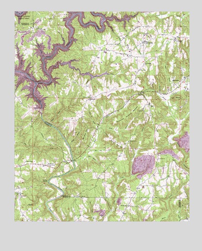
Cold Springs, AL USGS Topographic Map
Click on map above to begin viewing in our Map Viewer.

This topographic map contains these locations and features:
Feature Name Type Latitude Longitude GNIS ID View Map
Addington Chapel CemeteryCemeteryN33.9818°W87.0086°1805416View Map
Addington Chapel School (historical)SchoolN33.9829°W87.0094°134846View Map
Addington Chapel United Methodist ChurchChurchN33.9826°W87.0089°112931View Map
Antioch CemeteryCemeteryN33.9395°W87.0317°1730214View Map
Antioch Missionary Baptist ChurchChurchN33.9404°W87.0328°113163View Map
ArdellPopulated PlaceN33.9954°W87.0986°155999View Map
Arkadelphia Volunteer Fire Department Station 2BuildingN33.9135°W87.0221°2683107View Map
Banking GroundsCliffN33.8993°W87.1011°113445View Map
Barr HollowValleyN33.9143°W87.0739°113510View Map
Bear Pen BranchStreamN33.9787°W87.0914°113688View Map
Big BranchStreamN33.9951°W87.0472°114234View Map
Blevins HollowValleyN33.9329°W87.0992°114496View Map
Boyd CreekStreamN33.9062°W87.0819°114790View Map
Brazeal BranchStreamN33.9429°W87.0144°114854View Map
Bremen Post OfficePost OfficeN33.9804°W87.0334°1721320View Map
Bronson FordCrossingN33.9409°W87.1050°142286View Map
Browns Ferry (historical)CrossingN33.9307°W87.0908°134869View Map
Clinton BranchStreamN33.9645°W87.1217°116273View Map
Cold SpringsPopulated PlaceN33.9818°W87.0333°116391View Map
Cold Springs CemeteryCemeteryN33.9690°W87.0328°1805428View Map
Cold Springs ChurchChurchN33.9834°W87.0286°134879View Map
Cold Springs High SchoolSchoolN33.9820°W87.0322°134880View Map
Cold Springs MineMineN33.9765°W87.0236°134881View Map
Cold Springs Missionary Baptist ChurchChurchN33.9687°W87.0322°116397View Map
Cold Springs Volunteer Fire Department Station 1BuildingN33.9818°W87.0341°2683062View Map
Cold Springs Volunteer Fire Department Station 2BuildingN33.9522°W87.0575°2683060View Map
Coon CreekStreamN33.9954°W87.0614°116555View Map
Corinth CemeteryCemeteryN33.9123°W87.0219°1805430View Map
Corinth Church of ChristChurchN33.9126°W87.0217°116640View Map
Crane Hill Volunteer Fire Department Station 3BuildingN33.9982°W87.0962°2683081View Map
Doctor Harris Spring BranchStreamN33.9723°W87.1044°117330View Map
Dooley MountainSummitN33.9232°W87.0544°117377View Map
DrummondLocaleN33.8945°W87.1247°157373View Map
Drummond ChurchChurchN33.8912°W87.1208°142325View Map
Drummond School (historical)SchoolN33.8904°W87.1206°117491View Map
Gin MountainSummitN33.9495°W87.0075°118997View Map
Gravlee JunctionLocaleN33.8801°W87.0469°163898View Map
Hammonds Shinbone MountainSummitN33.9390°W87.0447°119658View Map
Henrys Mill (historical)LocaleN33.9023°W87.1183°165088View Map
Hope MineMineN33.8890°W87.0500°134916View Map
Jane BranchStreamN33.9501°W87.0128°120818View Map
John R HollowValleyN33.9309°W87.0656°120916View Map
Leeth HillSummitN33.8773°W87.0631°121486View Map
Lewis SmithDamN33.9368°W87.1050°131836View Map
Lick CreekStreamN33.9698°W87.0861°121595View Map
Lindseys Ferry (historical)CrossingN33.9112°W87.0833°134925View Map
Long BranchStreamN33.9629°W87.1014°121989View Map
Macedonia Baptist ChurchChurchN33.9476°W87.0725°122166View Map
Mail Route MountainSummitN33.9282°W87.0733°122223View Map
Mary Ann HollowValleyN33.9176°W87.0714°122352View Map
McKinley Chapel CemeteryCemeteryN33.9479°W87.0722°1805439View Map
McKinley Chapel Methodist ChurchChurchN33.9487°W87.0717°152284View Map
McKinley Chapel School (historical)SchoolN33.9484°W87.0714°134933View Map
Mill CreekStreamN33.9118°W87.0842°160105View Map
Mount Hope ChurchChurchN33.8837°W87.0453°123226View Map
New Hope ChurchChurchN33.8907°W87.1228°123835View Map
Oscar McGuffs MineMineN33.9348°W87.0278°136000View Map
Parker BranchStreamN33.9201°W87.0861°124438View Map
Parker BridgeBridgeN33.9104°W87.0853°124442View Map
Parker Ford (historical)CrossingN33.9112°W87.0828°163264View Map
Piney Woods ChurchChurchN33.8765°W87.1147°142417View Map
Piney Woods Community ChurchChurchN33.8757°W87.1006°157386View Map
Pineywoods Volunteer Fire DepartmentBuildingN33.9053°W87.1239°2683426View Map
PowellvillePopulated PlaceN33.9084°W87.0994°125230View Map
Rocky Springs AirparkAirportN33.9885°W87.0757°2770465View Map
Ryan CreekStreamN33.9570°W87.1094°126067View Map
Ryan Creek MineMineN33.9890°W87.1014°134956View Map
Sandlin Chapel United Methodist ChurchChurchN33.9587°W87.0069°153323View Map
Shady Grove CemeteryCemeteryN33.9226°W87.0439°1730225View Map
Shady Grove Primitive Baptist ChurchChurchN33.9223°W87.0433°153390View Map
Stewart BranchStreamN33.9020°W87.0411°127375View Map
Union Grove Baptist ChurchChurchN33.8895°W87.0803°128321View Map
Vaughans CrossroadLocaleN33.8854°W87.1189°165218View Map
Walls BranchStreamN33.9309°W87.0639°128545View Map
WilburnPopulated PlaceN33.9518°W87.0342°153986View Map
Williams ChapelChurchN33.9101°W87.1128°157407View Map
Willoughby BranchStreamN33.9954°W87.0614°129054View Map
Wilson BranchStreamN33.8868°W87.1017°129067View Map

Note: Coordinates in the location and feature list above are referenced to NAD83 datum.


Copyright (C) 2008-2025 Ryan Niemi / Sunset Dynamics ... All Rights Reserved