TopoQuest Logo
Do you find TopoQuest useful?
Help keep TopoQuest running and adding new maps/features by donating!
Bitcoin:  19c7KJd3qBynnjoSw5npx9KScwjBe4ifkT
Litecoin:  LXs6TkuXGGXo1vDsWCkWVdjQX94eUKd6ui
Home View Maps Find Maps Find Places Resources & Links


Sipsey, Alabama Topographic Map

USGS Map Title: Sipsey, AL
USGS Map MRC: 33087G1
DRG (GeoTIFF) Download: o33087g1.tif


Neighboring USGS Topographic Map Quads:


  Sunlight, AL  
33087H2
 

  Cold Springs, AL  
33087H1
 

  Arkadelphia, AL  
33086H8
 

  Cordova, AL  
33087G2
 

  Sipsey, AL  
33087G1
 

  Creel, AL  
33086G8
 

  Goodsprings, AL  
33087F2
 

  Dora, AL  
33087F1
 

  Brookside, AL  
33086F8


Map MRC Location:

N34°
W88°
N34°
W87°
H8 H7 H6 H5 H4 H3 H2 H1
G8 G7 G6 G5 G4 G3 G2 G1
F8 F7 F6 F5 F4 F3 F2 F1
E8 E7 E6 E5 E4 E3 E2 E1
D8 D7 D6 D5 D4 D3 D2 D1
C8 C7 C6 C5 C4 C3 C2 C1
B8 B7 B6 B5 B4 B3 B2 B1
A8 A7 A6 A5 A4 A3 A2 A1
N33°
W88°
N33°
W87°

Sipsey, AL USGS 1:24K Topographic Map Preview:
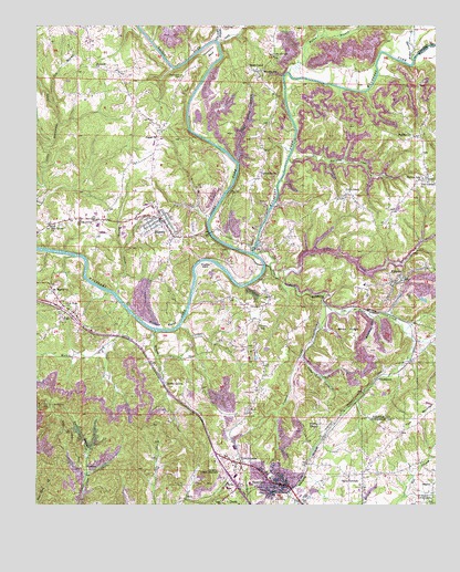
Sipsey, AL USGS Topographic Map
Click on map above to begin viewing in our Map Viewer.

This topographic map contains these locations and features:
Feature Name Type Latitude Longitude GNIS ID View Map
Akins Grove ChurchChurchN33.8243°W87.1114°112952View Map
Allen RidgeRidgeN33.7965°W87.0272°113013View Map
ArgoPopulated PlaceN33.8015°W87.1169°113205View Map
Argo Area Volunteer Fire DepartmentBuildingN33.8027°W87.1217°2682711View Map
Argo ChurchChurchN33.7948°W87.1022°142267View Map
Argo ChurchChurchN33.8023°W87.1225°142268View Map
Argo School (historical)SchoolN33.8021°W87.1161°142269View Map
Arthur Owens MineMineN33.8362°W87.0153°135943View Map
Aycock MineMineN33.8168°W87.0514°135981View Map
BagleyPopulated PlaceN33.7557°W87.0017°113338View Map
Baltimore FordCrossingN33.8665°W87.0672°142272View Map
Ben Gilbert MineMineN33.7709°W87.0833°135932View Map
Ben Gilbert MineMineN33.7709°W87.0819°135933View Map
Bill Grey DamDamN33.8484°W87.0733°131775View Map
Black Warrior Town (historical)Populated PlaceN33.8120°W87.0522°151556View Map
Bowden MineMineN33.8543°W87.0167°135942View Map
Briceston HollowValleyN33.8004°W87.0214°114885View Map
Bruton CreekStreamN33.7954°W87.0878°151703View Map
Burton BendBendN33.7962°W87.0828°151707View Map
Burton CemeteryCemeteryN33.8040°W87.0828°142288View Map
Burton CreekStreamN33.8054°W87.1003°151708View Map
Burtons Ferry (historical)CrossingN33.8001°W87.0956°151557View Map
Bush TowerLocaleN33.7762°W87.1194°115301View Map
Byrd-Cole Number 6 MineMineN33.8057°W87.0583°135984View Map
Camp SumitonLocaleN33.7562°W87.0278°115481View Map
CampbellvillePopulated PlaceN33.8365°W87.0553°115506View Map
City of SumitonCivilN33.7503°W87.0483°2405542View Map
Clark BranchStreamN33.8393°W87.0617°116171View Map
Clark Hollow MineMineN33.8487°W87.0625°135975View Map
Commercial (historical)LocaleN33.7576°W87.0597°142306View Map
Coon CreekPopulated PlaceN33.8312°W87.0283°116551View Map
Cordal Creek MineMineN33.7973°W87.0736°135973View Map
Cordell CreekStreamN33.7962°W87.0800°116625View Map
Country Village Shopping CenterLocaleN33.7557°W87.0611°1700550View Map
Cow BranchStreamN33.8545°W87.1192°116748View Map
DebardelebenPopulated PlaceN33.7959°W87.0056°157372View Map
Dickson FordCrossingN33.8626°W87.0467°142320View Map
DilworthPopulated PlaceN33.8023°W87.0536°117289View Map
Dilworth ChurchChurchN33.8001°W87.0556°142321View Map
Dilworth ChurchChurchN33.8043°W87.0519°142322View Map
Dilworth Drift MineMineN33.7987°W87.0500°135985View Map
Dilworth Memorial ChurchChurchN33.8076°W87.0542°163889View Map
Dodd Spring School (historical)SchoolN33.7907°W87.0556°142323View Map
Dora DivisionCivilN33.7525°W87.0880°165981View Map
Dora JunctionPopulated PlaceN33.7609°W87.0614°117379View Map
DrummondPopulated PlaceN33.7829°W87.0186°117488View Map
Drummond BendBendN33.8682°W87.0706°117489View Map
Drummond CemeteryCemeteryN33.8618°W87.0794°117490View Map
Drummond Ferry (historical)CrossingN33.8707°W87.0672°142326View Map
Eastside MineMineN33.8251°W87.0556°135978View Map
EmpirePopulated PlaceN33.8084°W87.0106°117987View Map
Empire DivisionCivilN33.8416°W87.0194°165982View Map
Empire Drift MineMineN33.8154°W87.0083°135946View Map
Empire Junior High School (historical)SchoolN33.8073°W87.0225°142330View Map
Empire MineMineN33.7682°W87.0431°135928View Map
Empire MineMineN33.8432°W87.0264°135945View Map
Empire Town Creek MineMineN33.7987°W87.0333°135939View Map
Empire Volunteer Fire DepartmentBuildingN33.8092°W87.0099°2683370View Map
Freewill ChurchChurchN33.8648°W87.1061°118637View Map
Gravleeton (historical)LocaleN33.8648°W87.0500°142361View Map
Headrick MineMineN33.8598°W87.0069°135941View Map
Henson MineMineN33.7918°W87.0153°135938View Map
HullPopulated PlaceN33.7743°W87.0589°120541View Map
Hull MineMineN33.7654°W87.0931°135934View Map
Ivy MineMineN33.7598°W87.0875°135931View Map
Jim Light BranchStreamN33.8712°W87.0683°120891View Map
Kerny MineMineN33.7834°W87.0375°135937View Map
KershawPopulated PlaceN33.7598°W87.1092°156552View Map
Kingdom Hall of Jehovahs WitnessesChurchN33.7793°W87.0842°163901View Map
Kirkwood MineMineN33.7640°W87.0472°135929View Map
Lake GreyReservoirN33.8484°W87.0733°131774View Map
Layton MineMineN33.7848°W87.0292°135936View Map
Ledbetter MineMineN33.7765°W87.0375°135935View Map
Leeth CreekStreamN33.8712°W87.0672°121485View Map
Levan Number 2 MineMineN33.8459°W87.0528°135976View Map
Little CreekStreamN33.8112°W87.0478°121758View Map
Little Creek Impoundment DamsDamN33.8118°W87.0433°131760View Map
Little Creek Mine LakeReservoirN33.8118°W87.0433°131761View Map
Lloyd-Watson MineMineN33.8029°W87.0333°135940View Map
LortonPopulated PlaceN33.7554°W87.0622°122031View Map
Magbee BendBendN33.8123°W87.0719°122200View Map
Mathis CreekStreamN33.7998°W87.0958°152248View Map
Mauldin CemeteryCemeteryN33.8679°W87.0500°122397View Map
Mount Pilgrim ChurchChurchN33.8059°W87.1203°123338View Map
Mullen BranchStreamN33.8632°W87.0458°123583View Map
New Canaan CemeteryCemeteryN33.8345°W87.0033°142398View Map
New Canaan ChurchChurchN33.8345°W87.0028°123732View Map
New Hope ChurchChurchN33.8032°W87.1164°123834View Map
No Business CreekStreamN33.8404°W87.0458°123958View Map
Oak Grove ChurchChurchN33.8226°W87.1206°124097View Map
Old Sipsey MineMineN33.8112°W87.0583°135983View Map
Old Town CreekStreamN33.8157°W87.0558°124261View Map
Owens Chapel ChurchChurchN33.8276°W87.0242°142409View Map
Petes CrossroadsPopulated PlaceN33.7507°W87.0014°124650View Map
Phillips CemeteryCemeteryN33.8473°W87.0094°157385View Map
Phillips ChapelChurchN33.7695°W87.0378°124685View Map
Phillips ChurchChurchN33.8473°W87.0089°124686View Map
Phillips Ferry (historical)CrossingN33.8157°W87.0561°163266View Map
Phillips Landing (historical)LocaleN33.8159°W87.1208°151572View Map
Phillips School (historical)SchoolN33.8357°W87.0042°124694View Map
Phillips ShoalsBarN33.8079°W87.0581°151573View Map
Pinhook CreekStreamN33.8023°W87.0344°124894View Map
Pisgah ChurchChurchN33.8462°W87.0872°124917View Map
Pledger MineMineN33.8084°W87.0722°135974View Map
Pugh MineMineN33.7937°W87.0389°135986View Map
Rices ChapelChurchN33.8640°W87.0558°153144View Map
Rocky HollowPopulated PlaceN33.7815°W87.0847°125859View Map
Rollo MineMineN33.8209°W87.0542°135980View Map
Rowe MineMineN33.7918°W87.0772°163267View Map
SipseyPopulated PlaceN33.8248°W87.0861°153455View Map
Sipsey ChurchChurchN33.8162°W87.0828°142436View Map
Sipsey ForkStreamN33.8157°W87.0572°160617View Map
Sipsey Junior High SchoolSchoolN33.8284°W87.0906°157395View Map
Sipsey MineMineN33.8057°W87.0931°135972View Map
Sipsey MineMineN33.8307°W87.0556°135977View Map
Sipsey Police DepartmentBuildingN33.8257°W87.0880°2752062View Map
Sipsey Post OfficePost OfficeN33.8242°W87.0858°2788965View Map
Sipsey Volunteer Fire DepartmentBuildingN33.8259°W87.0889°2682991View Map
SlossPopulated PlaceN33.7520°W87.0783°126978View Map
Stith MineMineN33.7584°W87.0583°135930View Map
SumitonPopulated PlaceN33.7557°W87.0500°153607View Map
Sumiton City HallBuildingN33.7523°W87.0492°1700551View Map
Sumiton Elementary SchoolSchoolN33.7570°W87.0522°142441View Map
Sumiton Fire and Rescue ServiceBuildingN33.7524°W87.0490°2682773View Map
Sumiton Police DepartmentBuildingN33.7529°W87.0501°2751911View Map
Sumiton Post OfficePost OfficeN33.7527°W87.0436°1700552View Map
Sumiton Trailer ParkPopulated PlaceN33.7623°W87.0406°1700553View Map
Town of SipseyCivilN33.8225°W87.0834°2407346View Map
Tremble MineMineN33.8195°W87.0528°135982View Map
Tucker HollowValleyN33.7879°W87.0417°128113View Map
Turkey HillSummitN33.7962°W87.0564°128168View Map
Walker County BranchStreamN33.8665°W87.0069°128515View Map
Wheeler School (historical)SchoolN33.8632°W87.0544°128841View Map
Winfred Owens MineMineN33.8293°W87.0444°135979View Map
WPYK-AM (Dora)TowerN33.8012°W87.1117°161035View Map
WRSM-AM (Sumiton)TowerN33.7640°W87.0631°161033View Map
York MineMineN33.8362°W87.0236°135944View Map

Note: Coordinates in the location and feature list above are referenced to NAD83 datum.


Copyright (C) 2008-2024 Ryan Niemi / Sunset Dynamics ... All Rights Reserved