TopoQuest Logo
Do you find TopoQuest useful?
Help keep TopoQuest running and adding new maps/features by donating!
Bitcoin:  19c7KJd3qBynnjoSw5npx9KScwjBe4ifkT
Litecoin:  LXs6TkuXGGXo1vDsWCkWVdjQX94eUKd6ui
Home View Maps Find Maps Find Places Resources & Links


Cornplanter Bridge, Pennsylvania Topographic Map

USGS Map Title: Cornplanter Bridge, PA
USGS Map MRC: 41078G8
DRG (GeoTIFF) Download: o41078g8.tif


Neighboring USGS Topographic Map Quads:


  Scandia, PA  
41079H1
 

  Cornplanter Run, PA  
41078H8
 

  Stickney, PA  
41078H7
 

  Clarendon, PA  
41079G1
 

  Cornplanter Bridge, PA  
41078G8
 

  Westline, PA  
41078G7
 

  Sheffield, PA  
41079F1
 

  Ludlow, PA  
41078F8
 

  Kane, PA  
41078F7


Map MRC Location:

N42°
W79°
N42°
W78°
H8 H7 H6 H5 H4 H3 H2 H1
G8 G7 G6 G5 G4 G3 G2 G1
F8 F7 F6 F5 F4 F3 F2 F1
E8 E7 E6 E5 E4 E3 E2 E1
D8 D7 D6 D5 D4 D3 D2 D1
C8 C7 C6 C5 C4 C3 C2 C1
B8 B7 B6 B5 B4 B3 B2 B1
A8 A7 A6 A5 A4 A3 A2 A1
N41°
W79°
N41°
W78°

Cornplanter Bridge, PA USGS 1:24K Topographic Map Preview:
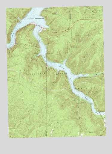
Cornplanter Bridge, PA USGS Topographic Map
Click on map above to begin viewing in our Map Viewer.

This topographic map contains these locations and features:
Feature Name Type Latitude Longitude GNIS ID View Map
Bent RunStreamN41.8359°W78.9975°1209417View Map
Bigrock Overflow AreaParkN41.7751°W78.8781°1210459View Map
Briggs RunStreamN41.8103°W78.8856°1209444View Map
Camp CornplanterLocaleN41.7848°W78.9125°1209473View Map
Campbell Mill Interpretive TrailTrailN41.8298°W78.9642°1210457View Map
Campbell RunStreamN41.8389°W78.9475°1209478View Map
Chappel BayBayN41.8078°W78.9048°1209493View Map
Chappel ForkStreamN41.8092°W78.8939°1209494View Map
Coal KnobSummitN41.8367°W78.9773°1210353View Map
Coal Knob Lookout TowerTowerN41.8364°W78.9764°1209512View Map
Cornplanter BridgeBridgeN41.8570°W78.9573°1209532View Map
Devils Elbow Fishing SiteLocaleN41.8534°W78.9825°1210456View Map
Devils Elbow Fishing SiteLocaleN41.8473°W78.9817°1210491View Map
Dew DropLocaleN41.8281°W78.9670°1212131View Map
Dewdrop (historical)LocaleN41.8301°W78.9548°1210348View Map
Dewdrop CampgroundLocaleN41.8320°W78.9592°1209557View Map
Dewdrop RunStreamN41.8281°W78.9617°1209558View Map
Dewdrop TrailTrailN41.8192°W78.9700°1209559View Map
Duncle Corners Fishing AreaParkN41.7956°W78.9120°1210463View Map
Dunkle CornersLocaleN41.7953°W78.9117°1210359View Map
Dunkle TrailTrailN41.7906°W78.9248°1209575View Map
Dutchman RunStreamN41.8120°W78.9336°1209578View Map
ElijahPopulated PlaceN41.8187°W78.9461°1210460View Map
Elijah RunStreamN41.8173°W78.9453°1209592View Map
Hemlock RunStreamN41.8106°W78.9045°1209668View Map
Jackson RunStreamN41.8628°W78.9814°1209699View Map
Jakes Rock Picnic AreaParkN41.8464°W78.9820°1210492View Map
Jakes RocksCliffN41.8509°W78.9823°1210352View Map
Jakes Rocks OverlookLocaleN41.8498°W78.9814°1209701View Map
Jakes RunStreamN41.8551°W78.9753°1209703View Map
Kettle RunStreamN41.7881°W78.8961°1209726View Map
Kiasutha Recreational AreaParkN41.7851°W78.9023°1209727View Map
Kinzua (historical)Populated PlaceN41.8634°W78.9614°1210347View Map
Kinzua BayBayN41.8117°W78.9220°1209731View Map
Kinzua BeachPopulated PlaceN41.8531°W78.9548°1209732View Map
Kinzua Beach Picnic AreaParkN41.8523°W78.9534°1210461View Map
Kinzua CreekStreamN41.8581°W78.9600°1209733View Map
Kinzua HeightsPopulated PlaceN41.8687°W78.9353°1209734View Map
Kinzua Point Information CenterLocaleN41.8595°W78.9634°1212130View Map
Lightning RunStreamN41.7862°W78.8931°1209758View Map
Longhouse Interprative TrailTrailN41.7792°W78.8953°1210464View Map
Ludlow TrailTrailN41.7592°W78.9450°1210189View Map
Mead Eddy RunStreamN41.8359°W78.9578°1209810View Map
Morrison (historical)Populated PlaceN41.8042°W78.9164°1213698View Map
Morrison CampgroundLocaleN41.8212°W78.9286°1209831View Map
Morrison RunStreamN41.8198°W78.9256°1209833View Map
Mud Lick RunStreamN41.7865°W78.9067°1209841View Map
North Branch Fourmile RunStreamN41.7576°W78.9934°1209857View Map
Old State Road CampgroundLocaleN41.8673°W78.9542°1210455View Map
Pine Grove CampgroundLocaleN41.8737°W78.9453°1209889View Map
Red BridgeBridgeN41.7717°W78.8817°1209919View Map
Red Bridge Bank Fishing AreaParkN41.7751°W78.8825°1210458View Map
Red Bridge CampgroundLocaleN41.7792°W78.8875°1210465View Map
Rimrock OverlookLocaleN41.8448°W78.9448°1209928View Map
Rimrock Picnic AreaLocaleN41.8448°W78.9448°1210454View Map
Rimrock Trail Morrison TrailTrailN41.8381°W78.9211°1210462View Map
Rock RunStreamN41.8573°W78.9442°1209933View Map
South Branch Kinzua CreekStreamN41.7698°W78.8778°1209998View Map
Swede HillSummitN41.7534°W78.8975°1210025View Map
Township of HamiltonCivilN41.7781°W78.8758°1216785View Map
Tuttle RunStreamN41.8409°W78.9887°1210064View Map
Tuttletown (historical)LocaleN41.8417°W78.9898°1210408View Map
Wolf RunStreamN41.8556°W78.9436°1210134View Map

Note: Coordinates in the location and feature list above are referenced to NAD83 datum.


Copyright (C) 2008-2025 Ryan Niemi / Sunset Dynamics ... All Rights Reserved