TopoQuest Logo
Do you find TopoQuest useful?
Help keep TopoQuest running and adding new maps/features by donating!
Bitcoin:  19c7KJd3qBynnjoSw5npx9KScwjBe4ifkT
Litecoin:  LXs6TkuXGGXo1vDsWCkWVdjQX94eUKd6ui
Home View Maps Find Maps Find Places Resources & Links


Scandia, Pennsylvania Topographic Map

USGS Map Title: Scandia, PA
USGS Map MRC: 41079H1
DRG (GeoTIFF) Download: o41079h1.tif


Neighboring USGS Topographic Map Quads:


  Jamestown, NY  
42079A2
 

  Ivory, NY  
42079A1
 

  Steamburg, NY  
42078A8
 

  Russell, PA  
41079H2
 

  Scandia, PA  
41079H1
 

  Cornplanter Run, PA  
41078H8
 

  Warren, PA  
41079G2
 

  Clarendon, PA  
41079G1
 

  Cornplanter Bridge, PA  
41078G8


Map MRC Location:

N42°
W80°
N42°
W79°
H8 H7 H6 H5 H4 H3 H2 H1
G8 G7 G6 G5 G4 G3 G2 G1
F8 F7 F6 F5 F4 F3 F2 F1
E8 E7 E6 E5 E4 E3 E2 E1
D8 D7 D6 D5 D4 D3 D2 D1
C8 C7 C6 C5 C4 C3 C2 C1
B8 B7 B6 B5 B4 B3 B2 B1
A8 A7 A6 A5 A4 A3 A2 A1
N41°
W80°
N41°
W79°

Scandia, PA USGS 1:24K Topographic Map Preview:
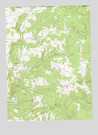
Scandia, PA USGS Topographic Map
Click on map above to begin viewing in our Map Viewer.

This topographic map contains these locations and features:
Feature Name Type Latitude Longitude GNIS ID View Map
Blueberry Hill Golf CourseLocaleN41.9553°W79.0175°1210358View Map
Bone Steel HillSummitN41.9078°W79.0756°1209441View Map
Cable HollowPopulated PlaceN41.9637°W79.0825°1209468View Map
Cable HollowValleyN41.9648°W79.0891°1209469View Map
Cable Hollow Golf CourseLocaleN41.9684°W79.1089°1210357View Map
Clendening CornersLocaleN41.9728°W79.0370°1209509View Map
Clendenning School (historical)SchoolN41.9723°W79.0375°1210326View Map
Cole HillSummitN41.9214°W79.0953°1209520View Map
Fox HillSummitN41.9537°W79.0948°1209614View Map
Gardners RocksSummitN41.9037°W79.1000°1209624View Map
Goose Heaven HillSummitN41.8973°W79.0892°1209636View Map
GouldtownPopulated PlaceN41.9951°W79.0881°1209639View Map
Hale CemeteryCemeteryN41.9812°W79.1231°1209654View Map
Hale SchoolSchoolN41.9817°W79.1234°1210329View Map
Lounsbury CornersLocaleN41.9584°W79.0150°1209782View Map
Macks CornersLocaleN41.9389°W79.0128°1209787View Map
Pine Grove GladeFlatN41.9134°W79.1117°1209890View Map
Priest HollowValleyN41.9389°W79.0698°1209909View Map
Priest Hollow School (historical)SchoolN41.9292°W79.0381°1210328View Map
Quaker RidgeRidgeN41.9220°W79.0298°1209911View Map
Reynolds RunStreamN41.9401°W79.0739°1209927View Map
Reynolds School (historical)SchoolN41.9528°W79.0381°1210327View Map
ScandiaPopulated PlaceN41.9128°W79.0353°1209957View Map
Scandia Air ParkAirportN41.9293°W79.0330°1210255View Map
Scandia Volunteer Fire DepartmentBuildingN41.9222°W79.0208°2645193View Map
Seven Dolors CemeteryCemeteryN41.9387°W79.0011°1209968View Map
Smith CemeteryCemeteryN41.8793°W79.0817°1209993View Map
Smith CornersLocaleN41.8834°W79.0720°1209994View Map
Smith SchoolSchoolN41.8839°W79.0714°1210330View Map
South RocksPillarN41.8973°W79.0889°1210002View Map
Sulphur Spring RunStreamN41.9406°W79.0712°1210023View Map
Township of Pine GroveCivilN41.9548°W79.1152°1217170View Map
Vanarsdale RunStreamN41.9656°W79.0898°1210071View Map
Warren RocksSummitN41.8926°W79.0523°1210084View Map
Widdlefield RunStreamN41.9309°W79.1123°1210115View Map
Wolcott RunStreamN41.9328°W79.1156°1210130View Map

Note: Coordinates in the location and feature list above are referenced to NAD83 datum.


Copyright (C) 2008-2025 Ryan Niemi / Sunset Dynamics ... All Rights Reserved