TopoQuest Logo
Do you find TopoQuest useful?
Help keep TopoQuest running and adding new maps/features by donating!
Bitcoin:  19c7KJd3qBynnjoSw5npx9KScwjBe4ifkT
Litecoin:  LXs6TkuXGGXo1vDsWCkWVdjQX94eUKd6ui
Home View Maps Find Maps Find Places Resources & Links


Clarendon, Pennsylvania Topographic Map

USGS Map Title: Clarendon, PA
USGS Map MRC: 41079G1
DRG (GeoTIFF) Download: o41079g1.tif


Neighboring USGS Topographic Map Quads:


  Russell, PA  
41079H2
 

  Scandia, PA  
41079H1
 

  Cornplanter Run, PA  
41078H8
 

  Warren, PA  
41079G2
 

  Clarendon, PA  
41079G1
 

  Cornplanter Bridge, PA  
41078G8
 

  Cherry Grove, PA  
41079F2
 

  Sheffield, PA  
41079F1
 

  Ludlow, PA  
41078F8


Map MRC Location:

N42°
W80°
N42°
W79°
H8 H7 H6 H5 H4 H3 H2 H1
G8 G7 G6 G5 G4 G3 G2 G1
F8 F7 F6 F5 F4 F3 F2 F1
E8 E7 E6 E5 E4 E3 E2 E1
D8 D7 D6 D5 D4 D3 D2 D1
C8 C7 C6 C5 C4 C3 C2 C1
B8 B7 B6 B5 B4 B3 B2 B1
A8 A7 A6 A5 A4 A3 A2 A1
N41°
W80°
N41°
W79°

Clarendon, PA USGS 1:24K Topographic Map Preview:
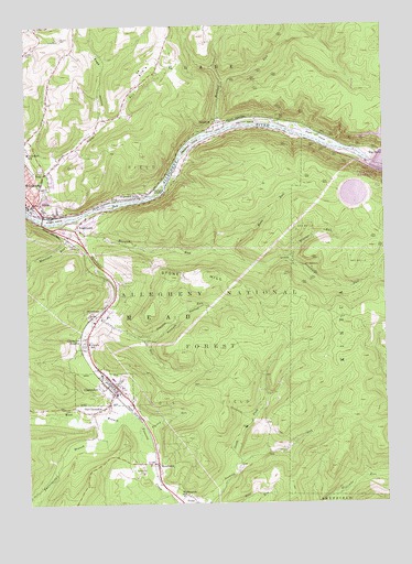
Clarendon, PA USGS Topographic Map
Click on map above to begin viewing in our Map Viewer.

This topographic map contains these locations and features:
Feature Name Type Latitude Longitude GNIS ID View Map
Allegheny National Fish HatcheryParkN41.8426°W79.0057°1210419View Map
Anderson RunStreamN41.8409°W79.0703°1212117View Map
Arnot RunStreamN41.7520°W79.0770°1209388View Map
Big BendPopulated PlaceN41.8409°W79.0042°1209419View Map
Big Bend Recreation SiteLocaleN41.8403°W79.0095°1210416View Map
Borough of ClarendonCivilN41.7806°W79.0940°1215646View Map
Browns RunStreamN41.8228°W79.1123°1209449View Map
ClarendonPopulated PlaceN41.7801°W79.0931°1209502View Map
Clarendon Fire DepartmentBuildingN41.7810°W79.0950°2644970View Map
Clarendon HeightsPopulated PlaceN41.7914°W79.1053°1209503View Map
Clarendon Post OfficePost OfficeN41.7803°W79.0934°2779972View Map
Corps of Engineers Visitor CenterLocaleN41.8417°W79.0123°1210418View Map
Cranberry SwampSwampN41.7715°W79.0964°1210374View Map
Dixon IslandIslandN41.8456°W79.0228°1209563View Map
Dutchman RunStreamN41.8195°W79.1039°1209579View Map
Farnsworth BranchStreamN41.7701°W79.0956°1210175View Map
Fluent RunStreamN41.8134°W79.0334°1209604View Map
Geers Ferry (historical)LocaleN41.8395°W79.0064°1210372View Map
GladePopulated PlaceN41.8276°W79.1206°1209633View Map
Glade RunStreamN41.8267°W79.1237°1209634View Map
Glade Volunteer Fire Department Station 57BuildingN41.8428°W79.1240°2644781View Map
Harmon IslandIslandN41.8495°W79.0470°1209659View Map
HemlockPopulated PlaceN41.8492°W79.0575°1209666View Map
Hemlock RunStreamN41.8473°W79.0584°1209669View Map
Hook RunStreamN41.8162°W79.0534°1209678View Map
Hooks Ferry (historical)LocaleN41.8462°W79.0589°1210373View Map
Irvinedale Elementary SchoolSchoolN41.8414°W79.1239°1213862View Map
Kinzua DamDamN41.8382°W79.0042°1217455View Map
Kinzua Pumped Storage DamDamN41.8317°W79.0131°1210260View Map
Knight IslandIslandN41.8242°W79.1148°1209738View Map
Lincoln SchoolSchoolN41.7917°W79.1031°1209759View Map
Morrison RunStreamN41.8220°W79.1075°1210196View Map
North Clarendon Post Office (historical)Post OfficeN41.7801°W79.0937°1210332View Map
North Fork Sixmile RunStreamN41.7587°W79.0528°1209865View Map
Old ClarendonPopulated PlaceN41.7739°W79.1017°1209870View Map
Pacard RunStreamN41.7670°W79.0825°1209874View Map
Page HollowValleyN41.8503°W79.0982°1209875View Map
Possum HollowValleyN41.7928°W79.0829°1209903View Map
Possum RunStreamN41.7931°W79.0864°1209904View Map
RogertownPopulated PlaceN41.8228°W79.1042°1209940View Map
Seneca Pumped Storage ReservoirReservoirN41.8306°W79.0100°1210259View Map
Shipmans EddyPopulated PlaceN41.8298°W79.0870°1209976View Map
Snyder CemeteryCemeteryN41.8687°W79.1243°1209996View Map
Stone HillSummitN41.8095°W79.0609°1210217View Map
StonehamPopulated PlaceN41.7992°W79.0995°1210017View Map
Township of GladeCivilN41.8717°W79.0665°1217166View Map
Township of Kinzua (historical)CivilN41.7834°W79.0164°1217167View Map
Township of MeadCivilN41.8144°W79.0239°1217169View Map
Verbeck IslandIslandN41.8317°W79.0781°1210074View Map
Ward RunStreamN41.8353°W79.0742°1212118View Map
WardwellLocaleN41.8434°W79.0648°1210409View Map
Wardwell IslandIslandN41.8434°W79.0667°1210081View Map
Washington SchoolSchoolN41.7523°W79.0698°1210087View Map
WeldbankPopulated PlaceN41.7603°W79.0798°1210093View Map
Weldbank Post Office (historical)Post OfficeN41.7603°W79.0798°1210331View Map
Wolf RunStreamN41.7512°W79.0620°1210137View Map

Note: Coordinates in the location and feature list above are referenced to NAD83 datum.


Copyright (C) 2008-2025 Ryan Niemi / Sunset Dynamics ... All Rights Reserved