TopoQuest Logo
Do you find TopoQuest useful?
Help keep TopoQuest running and adding new maps/features by donating!
Bitcoin:  19c7KJd3qBynnjoSw5npx9KScwjBe4ifkT
Litecoin:  LXs6TkuXGGXo1vDsWCkWVdjQX94eUKd6ui
Home View Maps Find Maps Find Places Resources & Links


Cottonwood Point, Missouri Topographic Map

USGS Map Title: Cottonwood Point, MO
USGS Map MRC: 36089A6
DRG (GeoTIFF) Download: o36089a6.tif


Neighboring USGS Topographic Map Quads:


  Hayti Heights, MO  
36089B7
 

  Caruthersville, MO  
36089B6
 

  Tennemo, TN  
36089B5
 

  Steele, MO  
36089A7
 

  Cottonwood Point, MO  
36089A6
 

  Caruthersville SE, TN  
36089A5
 

  Armorel, AR  
35089H7
 

  Chic, TN  
35089H6
 

  Knob Creek, TN  
35089H5


Map MRC Location:

N37°
W90°
N37°
W89°
H8 H7 H6 H5 H4 H3 H2 H1
G8 G7 G6 G5 G4 G3 G2 G1
F8 F7 F6 F5 F4 F3 F2 F1
E8 E7 E6 E5 E4 E3 E2 E1
D8 D7 D6 D5 D4 D3 D2 D1
C8 C7 C6 C5 C4 C3 C2 C1
B8 B7 B6 B5 B4 B3 B2 B1
A8 A7 A6 A5 A4 A3 A2 A1
N36°
W90°
N36°
W89°

Cottonwood Point, MO USGS 1:24K Topographic Map Preview:
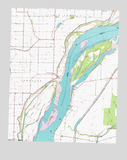
Cottonwood Point, MO USGS Topographic Map
Click on map above to begin viewing in our Map Viewer.

This topographic map contains these locations and features:
Feature Name Type Latitude Longitude GNIS ID View Map
Ashland TowheadAreaN36.0326°W89.7176°713439View Map
AyersPopulated PlaceN36.0792°W89.6420°1276022View Map
Ayers LandingLocaleN36.0823°W89.6420°1643387View Map
Bader BarBarN36.1065°W89.6259°1643388View Map
Big SloughGutN36.0070°W89.6576°1277391View Map
BradleytownPopulated PlaceN36.0020°W89.6490°1309780View Map
Cottonwood PointPopulated PlaceN36.0640°W89.6992°716372View Map
Cottonwood Point Census Designated PlaceCensusN36.0602°W89.7046°2587061View Map
Cottonwood Point DikesLeveeN36.0420°W89.6951°1309784View Map
Cottonwood Point Eagle BarBarN36.0834°W89.6723°1643392View Map
Cottonwood Point Ferry (historical)CrossingN36.0542°W89.6842°1309785View Map
Cottonwood Point LandingLocaleN36.0626°W89.6870°741824View Map
Everett LakeLakeN36.0693°W89.6567°1283920View Map
Flag Lake School (historical)SchoolN36.1170°W89.7448°741822View Map
Half Moon BayouStreamN36.0956°W89.7167°718996View Map
Half-Moon LakeReservoirN36.1088°W89.6961°765514View Map
Half-Moon Lake DamDamN36.1101°W89.6951°765513View Map
Head of Island Number Twentyone DikesLeveeN36.0084°W89.6987°1309807View Map
HeloisePopulated PlaceN36.0506°W89.6756°1315214View Map
Heloise LandingLocaleN36.0465°W89.6773°1309808View Map
Heloise RevetmentLeveeN36.0223°W89.6876°1309809View Map
Hickman CemeteryCemeteryN36.0890°W89.7042°719423View Map
Hunter SchoolSchoolN36.1015°W89.6851°741823View Map
Island Number 18IslandN36.0956°W89.6795°755232View Map
Island Number TwentyIslandN36.0079°W89.7237°1269680View Map
Island Number Twenty BarBarN36.0223°W89.7023°1643404View Map
Kinfolks RidgePopulated PlaceN36.1242°W89.6451°720602View Map
Long PondSwampN36.0367°W89.6265°1291997View Map
McCartyPopulated PlaceN36.1178°W89.6990°722035View Map
McCarty School (historical)SchoolN36.1176°W89.7001°746721View Map
MidwayLocaleN36.0106°W89.7351°730290View Map
MidwayPopulated PlaceN36.0059°W89.6892°1315501View Map
Midway CrevasseValleyN36.0090°W89.7348°738182View Map
Mitchell PointCapeN36.0540°W89.6784°1294115View Map
Needmore School (historical)SchoolN36.0956°W89.7095°746722View Map
Pleasant Grove ChurchChurchN36.0923°W89.6992°724483View Map
Riverside ChurchChurchN36.0684°W89.6448°1299521View Map
Skullbone BarBarN36.0917°W89.6667°1643416View Map
Stake SloughStreamN36.0142°W89.6340°1271201View Map
Taylor CemeteryCemeteryN36.0848°W89.6862°727488View Map
Towhead of Island Number EighteenFlatN36.0798°W89.6595°1272791View Map
Township of PemiscotCivilN36.0630°W89.7287°767149View Map
TylerPopulated PlaceN36.0340°W89.7373°727942View Map

Note: Coordinates in the location and feature list above are referenced to NAD83 datum.


Copyright (C) 2008-2025 Ryan Niemi / Sunset Dynamics ... All Rights Reserved