TopoQuest Logo
Do you find TopoQuest useful?
Help keep TopoQuest running and adding new maps/features by donating!
Bitcoin:  19c7KJd3qBynnjoSw5npx9KScwjBe4ifkT
Litecoin:  LXs6TkuXGGXo1vDsWCkWVdjQX94eUKd6ui
Home View Maps Find Maps Find Places Resources & Links


Caruthersville SE, Tennessee Topographic Map

USGS Map Title: Caruthersville SE, TN
USGS Map MRC: 36089A5
DRG (GeoTIFF) Download: o36089a5.tif


Neighboring USGS Topographic Map Quads:


  Caruthersville, MO  
36089B6
 

  Tennemo, TN  
36089B5
 

  Miston, TN  
36089B4
 

  Cottonwood Point, MO  
36089A6
 

  Caruthersville SE, TN  
36089A5
 

  Dyersburg, TN  
36089A4
 

  Chic, TN  
35089H6
 

  Knob Creek, TN  
35089H5
 

  Fowlkes, TN  
35089H4


Map MRC Location:

N37°
W90°
N37°
W89°
H8 H7 H6 H5 H4 H3 H2 H1
G8 G7 G6 G5 G4 G3 G2 G1
F8 F7 F6 F5 F4 F3 F2 F1
E8 E7 E6 E5 E4 E3 E2 E1
D8 D7 D6 D5 D4 D3 D2 D1
C8 C7 C6 C5 C4 C3 C2 C1
B8 B7 B6 B5 B4 B3 B2 B1
A8 A7 A6 A5 A4 A3 A2 A1
N36°
W90°
N36°
W89°

Caruthersville SE, TN USGS 1:24K Topographic Map Preview:
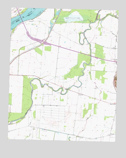
Caruthersville SE, TN USGS Topographic Map
Click on map above to begin viewing in our Map Viewer.

This topographic map contains these locations and features:
Feature Name Type Latitude Longitude GNIS ID View Map
Booth PointCapeN36.1126°W89.6056°1307413View Map
Booth Point DikesLeveeN36.1084°W89.6154°1309778View Map
Booth Point LandingLocaleN36.1131°W89.6076°1309779View Map
BoothspointPopulated PlaceN36.1126°W89.6029°1314717View Map
Commissioner District 5CivilN36.0327°W89.5674°2464439View Map
Coon CreekStreamN36.1153°W89.5217°1281167View Map
District 14 (historical)CivilN36.0167°W89.5542°1310273View Map
District 19 (historical)CivilN36.0834°W89.5959°1310271View Map
Emanuel ChurchChurchN36.0101°W89.5951°1283741View Map
Gum Flat School (historical)SchoolN36.0470°W89.5751°1309805View Map
Holiness Church (historical)ChurchN36.0503°W89.5579°1309812View Map
Island Number 17AreaN36.1195°W89.6173°755231View Map
Lenox Volunteer Fire DepartmentBuildingN36.0883°W89.5010°2653919View Map
Linwood BendBendN36.1231°W89.5909°737967View Map
Linwood Bend RevetmentLeveeN36.1209°W89.5890°1309821View Map
MengelwoodPopulated PlaceN36.0453°W89.5437°1293604View Map
Mississippi-Obion Division (historical)CensusN36.1162°W89.5287°1648680View Map
Pleasant Valley Church (historical)ChurchN36.0467°W89.5567°1309844View Map
RichwoodsPopulated PlaceN36.0065°W89.5062°1299378View Map
Rock SloughStreamN36.0748°W89.5315°1299778View Map
Running Reelfoot BayouStreamN36.1151°W89.5254°1303546View Map
Rush SloughGutN36.0287°W89.6006°1300268View Map
Rush Slough School (historical)SchoolN36.0101°W89.5962°1309849View Map
TylersvillePopulated PlaceN36.0042°W89.5415°1273150View Map
Whites LakeLakeN36.1159°W89.5538°1274463View Map

Note: Coordinates in the location and feature list above are referenced to NAD83 datum.


Copyright (C) 2008-2025 Ryan Niemi / Sunset Dynamics ... All Rights Reserved