TopoQuest Logo
Do you find TopoQuest useful?
Help keep TopoQuest running and adding new maps/features by donating!
Bitcoin:  19c7KJd3qBynnjoSw5npx9KScwjBe4ifkT
Litecoin:  LXs6TkuXGGXo1vDsWCkWVdjQX94eUKd6ui
Home View Maps Find Maps Find Places Resources & Links


East Point, Louisiana Topographic Map

USGS Map Title: East Point, LA
USGS Map MRC: 32093B4
DRG (GeoTIFF) Download: o32093b4.tif


Neighboring USGS Topographic Map Quads:


  Elm Grove, LA  
32093C5
 

  Bossier Point, LA  
32093C4
 

  Ringgold, LA  
32093C3
 

  Clear Lake, LA  
32093B5
 

  East Point, LA  
32093B4
 

  Hall Summit, LA  
32093B3
 

  Bayou Pierre Lake, LA  
32093A5
 

  Harmon, LA  
32093A4
 

  Coushatta, LA  
32093A3


Map MRC Location:

N33°
W94°
N33°
W93°
H8 H7 H6 H5 H4 H3 H2 H1
G8 G7 G6 G5 G4 G3 G2 G1
F8 F7 F6 F5 F4 F3 F2 F1
E8 E7 E6 E5 E4 E3 E2 E1
D8 D7 D6 D5 D4 D3 D2 D1
C8 C7 C6 C5 C4 C3 C2 C1
B8 B7 B6 B5 B4 B3 B2 B1
A8 A7 A6 A5 A4 A3 A2 A1
N32°
W94°
N32°
W93°

East Point, LA USGS 1:24K Topographic Map Preview:
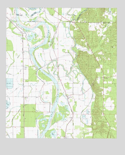
East Point, LA USGS Topographic Map
Click on map above to begin viewing in our Map Viewer.

This topographic map contains these locations and features:
Feature Name Type Latitude Longitude GNIS ID View Map
Alligator BayouGutN32.1754°W93.4138°532120View Map
Bayou PierrePopulated PlaceN32.1485°W93.4802°548737View Map
Coushatta BayouGutN32.1463°W93.4157°554105View Map
Crichton LakeLakeN32.1284°W93.4471°554129View Map
Crooked BayouGutN32.1471°W93.4893°534260View Map
Cross RoadsPopulated PlaceN32.1835°W93.3899°540639View Map
CrosskeysPopulated PlaceN32.2371°W93.4955°554139View Map
Des Arc Oil FieldOilfieldN32.2149°W93.4668°548744View Map
East Hope Gas FieldOilfieldN32.1440°W93.4124°548745View Map
East PointPopulated PlaceN32.1654°W93.4313°554331View Map
East Point Post OfficePost OfficeN32.1671°W93.4255°1630815View Map
Elizabeth ChurchChurchN32.1646°W93.4660°534793View Map
Flat RiverStreamN32.2396°W93.4241°554434View Map
Fourmile BayouGutN32.1482°W93.4255°535065View Map
Grassy LakeLakeN32.2071°W93.4288°554596View Map
Grassy Lake Gas FieldOilfieldN32.2015°W93.4430°548746View Map
Halls SloughGutN32.1488°W93.4030°535501View Map
HowardPopulated PlaceN32.2265°W93.4827°554791View Map
Liberty Hill ChurchChurchN32.2352°W93.3982°536428View Map
Loggy BayouPopulated PlaceN32.1999°W93.4421°548753View Map
Loggy BayouStreamN32.1860°W93.4507°555127View Map
Long LakeLakeN32.2157°W93.4504°555152View Map
New Era ChurchChurchN32.2140°W93.4493°537565View Map
New HopePopulated PlaceN32.1446°W93.4249°543518View Map
New Jerusalem ChurchChurchN32.1782°W93.4241°537592View Map
NinockPopulated PlaceN32.2468°W93.4571°543526View Map
Parish Governing Authority District 4CivilN32.1287°W93.4581°1930027View Map
Powell BayouGutN32.1993°W93.4896°538373View Map
Prudhomme Lake (historical)LakeN32.1802°W93.4752°556618View Map
Riverdale Academy SchoolSchoolN32.1637°W93.4293°2462734View Map
Saint John the Baptist ChurchChurchN32.1946°W93.4782°541312View Map
Saint Marks CemeteryCemeteryN32.2124°W93.3782°538966View Map
Saint Mary ChurchChurchN32.1577°W93.4791°538977View Map
Spring Hill BranchStreamN32.2265°W93.3899°539592View Map
Thomas LandingLocaleN32.2465°W93.4127°549111View Map
Toulon BayouStreamN32.2149°W93.4210°540641View Map
Toulon Bayou Gas FieldOilfieldN32.2160°W93.3905°548769View Map
Toulon Bayou Number One DamDamN32.2468°W93.3802°556749View Map
True Vine ChurchChurchN32.2279°W93.4168°540005View Map
Turners LakeSwampN32.1527°W93.4666°540048View Map
WestdalePopulated PlaceN32.1649°W93.4799°541213View Map
WilliamsPopulated PlaceN32.1940°W93.4810°556423View Map
Williams Gas FieldOilfieldN32.1871°W93.4752°548772View Map

Note: Coordinates in the location and feature list above are referenced to NAD83 datum.


Copyright (C) 2008-2024 Ryan Niemi / Sunset Dynamics ... All Rights Reserved