TopoQuest Logo
Do you find TopoQuest useful?
Help keep TopoQuest running and adding new maps/features by donating!
Bitcoin:  19c7KJd3qBynnjoSw5npx9KScwjBe4ifkT
Litecoin:  LXs6TkuXGGXo1vDsWCkWVdjQX94eUKd6ui
Home View Maps Find Maps Find Places Resources & Links


Harmon, Louisiana Topographic Map

USGS Map Title: Harmon, LA
USGS Map MRC: 32093A4
DRG (GeoTIFF) Download: o32093a4.tif


Neighboring USGS Topographic Map Quads:


  Clear Lake, LA  
32093B5
 

  East Point, LA  
32093B4
 

  Hall Summit, LA  
32093B3
 

  Bayou Pierre Lake, LA  
32093A5
 

  Harmon, LA  
32093A4
 

  Coushatta, LA  
32093A3
 

  Pelican, LA  
31093H5
 

  Evelyn, LA  
31093H4
 

  Hanna, LA  
31093H3


Map MRC Location:

N33°
W94°
N33°
W93°
H8 H7 H6 H5 H4 H3 H2 H1
G8 G7 G6 G5 G4 G3 G2 G1
F8 F7 F6 F5 F4 F3 F2 F1
E8 E7 E6 E5 E4 E3 E2 E1
D8 D7 D6 D5 D4 D3 D2 D1
C8 C7 C6 C5 C4 C3 C2 C1
B8 B7 B6 B5 B4 B3 B2 B1
A8 A7 A6 A5 A4 A3 A2 A1
N32°
W94°
N32°
W93°

Harmon, LA USGS 1:24K Topographic Map Preview:
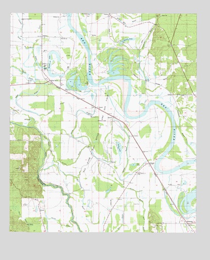
Harmon, LA USGS Topographic Map
Click on map above to begin viewing in our Map Viewer.

This topographic map contains these locations and features:
Feature Name Type Latitude Longitude GNIS ID View Map
AbingtonPopulated PlaceN32.1115°W93.4788°541041View Map
ArmisteadPopulated PlaceN32.0054°W93.3805°532214View Map
Barnes Lake (historical)LakeN32.1131°W93.4639°541317View Map
Beard LakeLakeN32.1104°W93.4213°553550View Map
Blue HoleLakeN32.0644°W93.4863°553718View Map
Blue Hole BayouGutN32.1018°W93.4843°533237View Map
Boggy BayouGutN32.0785°W93.4938°533275View Map
Boon BrakeSwampN32.0038°W93.4863°533327View Map
Bright and Morning Star ChurchChurchN32.1215°W93.4921°533400View Map
Bull BayouGutN32.0054°W93.4241°533527View Map
Butler SloughGutN32.0693°W93.4674°533592View Map
CarrollPopulated PlaceN32.0788°W93.3916°553904View Map
Corinth ChurchChurchN32.0840°W93.4660°534135View Map
Couchanda HillSummitN32.0041°W93.4021°548741View Map
CrichtonPopulated PlaceN32.1246°W93.4335°554128View Map
EmmettPopulated PlaceN32.0718°W93.4427°543181View Map
Fortson (historical)Populated PlaceN32.0516°W93.4863°545627View Map
GahaganPopulated PlaceN32.0399°W93.4066°541097View Map
Garsia BayouGutN32.0046°W93.4655°554512View Map
Grand BayouPopulated PlaceN32.0868°W93.4732°543251View Map
Grand BayouGutN32.0927°W93.4943°554568View Map
Grand Bayou School (historical)SchoolN32.0943°W93.4613°541316View Map
Greenings Ferry (historical)CrossingN32.0557°W93.4788°549485View Map
HarmonPopulated PlaceN32.0660°W93.4305°543279View Map
Harmon Post OfficePost OfficeN32.0663°W93.4307°1630822View Map
Heart BayouStreamN32.0052°W93.4880°535590View Map
Honey BayouGutN32.0635°W93.4555°535766View Map
Kenney BayouGutN32.0813°W93.4160°541323View Map
Lee LakeLakeN32.0388°W93.4170°555011View Map
Linsberry (historical)Populated PlaceN32.1099°W93.4274°556619View Map
Macedonia Church (historical)ChurchN32.0893°W93.4985°541315View Map
MagnoliaPopulated PlaceN32.0399°W93.4327°543431View Map
Mary Magdalene ChurchChurchN32.0341°W93.4143°536928View Map
Morgan CreekStreamN32.0818°W93.4099°537206View Map
Morning Star Church (historical)ChurchN32.0563°W93.4332°541321View Map
Morrison CemeteryCemeteryN32.1229°W93.4671°537237View Map
Moss LakeSwampN32.0535°W93.4432°541320View Map
Mount Olive ChurchChurchN32.1032°W93.4777°537363View Map
New Beulah ChurchChurchN32.0815°W93.4632°537555View Map
New Beulah Church (historical)ChurchN32.0566°W93.4732°541319View Map
New Star CemeteryCemeteryN32.1107°W93.4663°537630View Map
New Star Church (historical)ChurchN32.1110°W93.4657°541318View Map
Old Mary Magdalene ChurchChurchN32.0674°W93.4457°555542View Map
OxbowPopulated PlaceN32.0243°W93.3957°548758View Map
Polly LakeLakeN32.0495°W93.4266°555699View Map
Red River Bull Bayou Oil FieldOilfieldN32.0596°W93.4399°538529View Map
Robinson LakeSwampN32.0635°W93.4416°538653View Map
Shingle BayouGutN32.0399°W93.4566°539346View Map
Starlight ChurchChurchN32.0054°W93.3982°539632View Map
Stuart AirstripAirportN32.0185°W93.4317°1632671View Map
Susie BayouGutN32.0260°W93.4227°539746View Map
Susie Island School (historical)SchoolN32.0232°W93.4143°541322View Map
Tanyard CemeteryCemeteryN32.1240°W93.3991°556203View Map
Taylor CemeteryCemeteryN32.0952°W93.4777°539801View Map
The CutoffBendN32.0860°W93.4468°539847View Map
Ward FourCivilN32.1118°W93.4521°545182View Map
Ware Youth Center SchoolSchoolN32.0802°W93.3751°2462749View Map
WemplePopulated PlaceN32.0124°W93.4796°541212View Map
Willow Bay BayouGutN32.1185°W93.4224°540448View Map
Willow Grove ChurchChurchN32.0466°W93.4110°540460View Map
Wilson CemeteryCemeteryN32.0874°W93.4752°548773View Map
Wilson CemeteryCemeteryN32.0935°W93.4777°540483View Map
Wilson LakeLakeN32.0899°W93.4724°556454View Map

Note: Coordinates in the location and feature list above are referenced to NAD83 datum.


Copyright (C) 2008-2024 Ryan Niemi / Sunset Dynamics ... All Rights Reserved