TopoQuest Logo
Do you find TopoQuest useful?
Help keep TopoQuest running and adding new maps/features by donating!
Bitcoin:  19c7KJd3qBynnjoSw5npx9KScwjBe4ifkT
Litecoin:  LXs6TkuXGGXo1vDsWCkWVdjQX94eUKd6ui
Home View Maps Find Maps Find Places Resources & Links


Arkabutla East, Mississippi Topographic Map

USGS Map Title: Arkabutla East, MS
USGS Map MRC: 34090F1
DRG (GeoTIFF) Download: o34090f1.tif


Neighboring USGS Topographic Map Quads:


  Banks, MS  
34090G2
 

  Frees Corners, MS  
34090G1
 

  Hernando, MS  
34089G8
 

  Arkabutla West, MS  
34090F2
 

  Arkabutla East, MS  
34090F1
 

  Coldwater, MS  
34089F8
 

  Crenshaw North, MS  
34090E2
 

  Longtown, MS  
34090E1
 

  Senatobia, MS  
34089E8


Map MRC Location:

N35°
W91°
N35°
W90°
H8 H7 H6 H5 H4 H3 H2 H1
G8 G7 G6 G5 G4 G3 G2 G1
F8 F7 F6 F5 F4 F3 F2 F1
E8 E7 E6 E5 E4 E3 E2 E1
D8 D7 D6 D5 D4 D3 D2 D1
C8 C7 C6 C5 C4 C3 C2 C1
B8 B7 B6 B5 B4 B3 B2 B1
A8 A7 A6 A5 A4 A3 A2 A1
N34°
W91°
N34°
W90°

Arkabutla East, MS USGS 1:24K Topographic Map Preview:
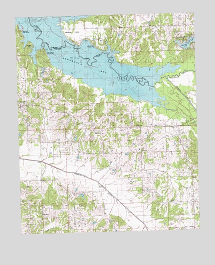
Arkabutla East, MS USGS Topographic Map
Click on map above to begin viewing in our Map Viewer.

This topographic map contains these locations and features:
Feature Name Type Latitude Longitude GNIS ID View Map
Antioch Church Number 2ChurchN34.6862°W90.0420°666337View Map
ArkabutlaPopulated PlaceN34.6990°W90.1223°666362View Map
Arkabutla Baptist ChurchChurchN34.6979°W90.1245°705987View Map
Arkabutla LakeReservoirN34.7365°W90.0984°690215View Map
Arkabutla Post OfficePost OfficeN34.6986°W90.1230°2768615View Map
Bayou PointCapeN34.7437°W90.1187°666613View Map
Bayou Point Public Use AreaParkN34.7445°W90.1209°683397View Map
Bluff (historical)LocaleN34.7362°W90.0487°690468View Map
Brooks ChapelChurchN34.6707°W90.0387°667601View Map
Buena Vista LakesPopulated PlaceN34.7348°W90.0070°690469View Map
Buena Vista Lakes DamDamN34.7284°W90.0084°690420View Map
Buena Vista Lakes DamDamN34.7334°W90.0018°690422View Map
Doctor J Cash King Lake DamDamN34.7251°W90.1118°682788View Map
Ebenezer ChurchChurchN34.6259°W90.0043°683418View Map
Ebenezer School (historical)SchoolN34.6259°W90.0043°1805837View Map
EliphazPopulated PlaceN34.6557°W90.1187°683419View Map
Haas-Rush Lake DamDamN34.7268°W90.1151°682790View Map
Hammond School (historical)SchoolN34.6851°W90.0179°1805840View Map
Hernando PointCapeN34.7398°W90.0773°690293View Map
Hernando Point Public Use AreaParkN34.7320°W90.0695°690520View Map
Hickahala CreekStreamN34.7082°W90.0304°690294View Map
Hidden Valley Incorporated Lake DamDamN34.6801°W90.0868°682772View Map
Hidden Valley Incorporated Lake DamDamN34.6818°W90.0918°682774View Map
Hill ChapelChurchN34.6557°W90.0043°671210View Map
Hills School (historical)SchoolN34.6548°W90.0040°1805841View Map
Hunter ChapelChurchN34.6362°W90.1098°671588View Map
Hunters Chapel School (historical)SchoolN34.6362°W90.1095°706001View Map
Kelleys CrossingPopulated PlaceN34.7279°W90.1051°691976View Map
Kelleys Crossing Public Use AreaParkN34.7293°W90.1056°683435View Map
Morris CemeteryCemeteryN34.6332°W90.1084°683450View Map
Murry (historical)LocaleN34.6776°W90.0862°683455View Map
Oak Hill ChurchChurchN34.7429°W90.0490°690368View Map
Oak Hill School (historical)SchoolN34.7426°W90.0495°690565View Map
Rain Cloud LakeReservoirN34.7348°W90.0016°690584View Map
Saint Andrew School (historical)SchoolN34.6776°W90.0979°1805844View Map
Saint Peter ChurchChurchN34.6565°W90.1098°677246View Map
Shelly (historical)LocaleN34.6654°W90.1181°683473View Map
Sunfish BayBayN34.7329°W90.1126°678410View Map
Sunfish Bay Public Use AreaParkN34.7348°W90.1140°683478View Map
Supervisor District 2CivilN34.6840°W90.1151°712091View Map
Sweet Grove ChurchChurchN34.6829°W90.0706°678467View Map
Sweet Grove School (historical)SchoolN34.6826°W90.0715°1805849View Map
Tatesville (historical)LocaleN34.6409°W90.0043°706014View Map
Tatumsville (historical)LocaleN34.6279°W90.0043°706015View Map
Thunderbird LakeReservoirN34.7317°W90.0075°690600View Map
Veazley Grove School (historical)SchoolN34.6640°W90.0509°1805850View Map
W P Veazey Junior Pond DamDamN34.6468°W90.0818°682754View Map
W P Veazey Junior Pond DamDamN34.6634°W90.0851°682762View Map
West Antioch Church Number 1ChurchN34.6412°W90.0195°679467View Map
West Tate Elementary SchoolSchoolN34.6832°W90.0565°711679View Map
WNJC-FM (Senatobia)TowerN34.6484°W90.0226°680266View Map

Note: Coordinates in the location and feature list above are referenced to NAD83 datum.


Copyright (C) 2008-2024 Ryan Niemi / Sunset Dynamics ... All Rights Reserved