TopoQuest Logo
Do you find TopoQuest useful?
Help keep TopoQuest running and adding new maps/features by donating!
Bitcoin:  19c7KJd3qBynnjoSw5npx9KScwjBe4ifkT
Litecoin:  LXs6TkuXGGXo1vDsWCkWVdjQX94eUKd6ui
Home View Maps Find Maps Find Places Resources & Links


Crossville, Illinois Topographic Map

USGS Map Title: Crossville, IL
USGS Map MRC: 38088B1
DRG (GeoTIFF) Download: o38088b1.tif


Neighboring USGS Topographic Map Quads:


  Golden Gate, IL  
38088C2
 

  Albion South, IL  
38088C1
 

  Grayville, IL  
38087C8
 

  Centerville, IL  
38088B2
 

  Crossville, IL  
38088B1
 

  New Harmony, IN  
38087B8
 

  Carmi, IL  
38088A2
 

  Maunie, IL  
38088A1
 

  Solitude, IN  
38087A8


Map MRC Location:

N39°
W89°
N39°
W88°
H8 H7 H6 H5 H4 H3 H2 H1
G8 G7 G6 G5 G4 G3 G2 G1
F8 F7 F6 F5 F4 F3 F2 F1
E8 E7 E6 E5 E4 E3 E2 E1
D8 D7 D6 D5 D4 D3 D2 D1
C8 C7 C6 C5 C4 C3 C2 C1
B8 B7 B6 B5 B4 B3 B2 B1
A8 A7 A6 A5 A4 A3 A2 A1
N38°
W89°
N38°
W88°

Crossville, IL USGS 1:24K Topographic Map Preview:
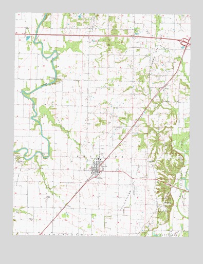
Crossville, IL USGS Topographic Map
Click on map above to begin viewing in our Map Viewer.

This topographic map contains these locations and features:
Feature Name Type Latitude Longitude GNIS ID View Map
Bell School (historical)SchoolN38.1575°W88.0328°1705665View Map
Bethel CemeteryCemeteryN38.1859°W88.0523°404265View Map
Bethel ChurchChurchN38.1925°W88.0542°404292View Map
Blackledge School (historical)SchoolN38.1912°W88.1234°1705666View Map
Brown CemeteryCemeteryN38.1339°W88.1106°404938View Map
Brush School (historical)SchoolN38.2270°W88.0589°1705671View Map
Bryant Valley Church (historical)ChurchN38.2053°W88.0731°1705672View Map
Bumblebee Bend School (historical)SchoolN38.1484°W88.1150°1705673View Map
CalvinPopulated PlaceN38.2081°W88.0186°405411View Map
Calvin CemeteryCemeteryN38.2009°W88.0192°405980View Map
Charles School (historical)SchoolN38.2017°W88.0192°1705675View Map
Cherry CemeteryCemeteryN38.1659°W88.1225°406025View Map
Cherry Shoals BridgeBridgeN38.1709°W88.1053°424740View Map
Crooked CreekStreamN38.1703°W88.1095°406799View Map
CrossvillePopulated PlaceN38.1617°W88.0653°406840View Map
Crossville Elementary SchoolSchoolN38.1678°W88.0634°1823951View Map
Crossville Police DepartmentBuildingN38.1618°W88.0647°2758928View Map
Crossville Post OfficePost OfficeN38.1614°W88.0659°2788889View Map
Crossville Volunteer Fire DepartmentBuildingN38.1618°W88.0644°2681922View Map
Elliott CreekStreamN38.1889°W88.1073°407894View Map
Fairview School (historical)SchoolN38.2442°W88.0773°1705681View Map
French School (historical)SchoolN38.2300°W88.0156°1705683View Map
Goodman School (historical)SchoolN38.1698°W88.0903°1705686View Map
Graves School (historical)SchoolN38.1398°W88.0781°1705688View Map
Hanks Ferry BridgeBridgeN38.2131°W88.0959°424963View Map
Harper (historical)Populated PlaceN38.1839°W88.0425°1823968View Map
Hughes School (historical)SchoolN38.1720°W88.0178°1705691View Map
Interchange 130CrossingN38.2348°W88.0042°1823970View Map
Little Wabash ChurchChurchN38.1578°W88.0300°412428View Map
New Harmony Oil FieldOilfieldN38.1687°W88.0031°425237View Map
Oakland School (historical)SchoolN38.2484°W88.0403°1705698View Map
PhillipstownPopulated PlaceN38.1420°W88.0217°415616View Map
Phillipstown Oil FieldOilfieldN38.1995°W88.0370°425329View Map
Riverside CemeteryCemeteryN38.2100°W88.0978°416713View Map
Riverside School (historical)SchoolN38.2131°W88.0934°1705699View Map
Salem ChurchChurchN38.2123°W88.0814°417867View Map
Shortville School (historical)SchoolN38.2270°W88.1220°1705705View Map
Stokes ChapelChurchN38.1462°W88.1011°419157View Map
Sumpter East Oil FieldOilfieldN38.1545°W88.1242°425536View Map
Township of GrayCivilN38.2351°W88.0673°429074View Map
Township of PhillipsCivilN38.1681°W88.0485°429557View Map
Union CemeteryCemeteryN38.2164°W88.0714°1823982View Map
Union ChurchChurchN38.2164°W88.0723°420049View Map
Village of CrossvilleCivilN38.1625°W88.0643°2398655View Map
Village of PhillipstownCivilN38.1429°W88.0181°2399664View Map
Whiting Family CemeteryCemeteryN38.1323°W88.0284°421104View Map
Whitsett School (historical)SchoolN38.1903°W88.0731°1705713View Map

Note: Coordinates in the location and feature list above are referenced to NAD83 datum.


Copyright (C) 2008-2025 Ryan Niemi / Sunset Dynamics ... All Rights Reserved