TopoQuest Logo
Do you find TopoQuest useful?
Help keep TopoQuest running and adding new maps/features by donating!
Bitcoin:  19c7KJd3qBynnjoSw5npx9KScwjBe4ifkT
Litecoin:  LXs6TkuXGGXo1vDsWCkWVdjQX94eUKd6ui
Home View Maps Find Maps Find Places Resources & Links


Solitude, Indiana Topographic Map

USGS Map Title: Solitude, IN
USGS Map MRC: 38087A8
DRG (GeoTIFF) Download: o38087a8.tif


Neighboring USGS Topographic Map Quads:


  Crossville, IL  
38088B1
 

  New Harmony, IN  
38087B8
 

  Poseyville, IN  
38087B7
 

  Maunie, IL  
38088A1
 

  Solitude, IN  
38087A8
 

  Wadesville, IN  
38087A7
 

  Emma, IL  
37088H1
 

  Mount Vernon, IN  
37087H8
 

  Caborn, IN  
37087H7


Map MRC Location:

N39°
W88°
N39°
W87°
H8 H7 H6 H5 H4 H3 H2 H1
G8 G7 G6 G5 G4 G3 G2 G1
F8 F7 F6 F5 F4 F3 F2 F1
E8 E7 E6 E5 E4 E3 E2 E1
D8 D7 D6 D5 D4 D3 D2 D1
C8 C7 C6 C5 C4 C3 C2 C1
B8 B7 B6 B5 B4 B3 B2 B1
A8 A7 A6 A5 A4 A3 A2 A1
N38°
W88°
N38°
W87°

Solitude, IN USGS 1:24K Topographic Map Preview:
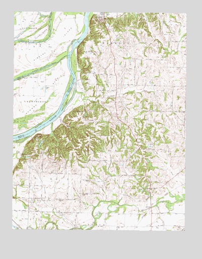
Solitude, IN USGS Topographic Map
Click on map above to begin viewing in our Map Viewer.

This topographic map contains these locations and features:
Feature Name Type Latitude Longitude GNIS ID View Map
Alexander CemeteryCemeteryN38.0170°W87.9664°430060View Map
Alexander CreekStreamN38.0009°W87.9553°430062View Map
Beech Grove CemeteryCemeteryN38.0203°W87.9495°430720View Map
Beech Grove RunStreamN38.0134°W87.9395°430733View Map
Bend RunStreamN38.0895°W87.9559°430797View Map
Bethesda ChurchChurchN38.0164°W87.9786°430966View Map
Bowman BendBendN38.0717°W87.9745°404747View Map
Camp PahokaParkN38.0517°W87.9811°432053View Map
Cord RunStreamN38.1103°W87.8973°432962View Map
Culley Acres AirportAirportN38.0339°W87.9851°2717323View Map
Duo RunStreamN38.0381°W87.8878°433804View Map
Fox RiverStreamN38.1214°W87.9739°408637View Map
French CemeteryCemeteryN38.0323°W87.9725°434828View Map
French RunStreamN38.0184°W87.9739°434834View Map
Fun CreekStreamN38.0153°W87.9231°434901View Map
Gin RunStreamN38.0803°W87.9120°435087View Map
Goad BrookStreamN38.0167°W87.9320°435137View Map
GraftonPopulated PlaceN38.0014°W87.9542°435276View Map
Ha Brook CreekStreamN38.0242°W87.9200°435572View Map
Harmonie State ParkParkN38.0639°W87.9528°447654View Map
Harmonist CemeteryCemeteryN38.1211°W87.9375°447665View Map
Hawthorne CreekStreamN38.0750°W87.9331°435909View Map
Large DrainStreamN38.0020°W87.9873°437631View Map
Long RunStreamN38.0781°W87.9223°438281View Map
Maple Hill CemeteryCemeteryN38.1198°W87.9370°438564View Map
Maple RunStreamN38.1198°W87.9459°438576View Map
McFadden CemeteryCemeteryN38.0428°W87.9936°438859View Map
Melody RunStreamN38.1087°W87.8800°438975View Map
Murphy ParkParkN38.1237°W87.9339°439892View Map
Nest RunStreamN38.0220°W87.9323°439999View Map
New Harmony State MemorialParkN38.1209°W87.9334°447664View Map
Oka RunStreamN38.0548°W87.9709°440526View Map
Olive ChapelChurchN38.0023°W87.8947°440646View Map
Olive CreekStreamN38.0145°W87.8956°440650View Map
Oliver RunStreamN38.0803°W87.9064°440657View Map
Pahoka Camp LakeReservoirN38.0492°W87.9800°447858View Map
Pahoka Camp Lake DamDamN38.0517°W87.9784°447857View Map
Pahoka CreekStreamN38.0614°W87.9720°440828View Map
Ribeyre IslandIslandN38.1064°W87.9686°441934View Map
Road BrookStreamN38.0648°W87.9667°442124View Map
Rush CreekStreamN38.0803°W87.9548°442400View Map
Russell PondLakeN38.1112°W87.9968°417066View Map
SavahPopulated PlaceN38.0178°W87.9786°443047View Map
SolitudePopulated PlaceN38.0148°W87.8989°443755View Map
Solitude Post Office (historical)Post OfficeN38.0231°W87.9011°452998View Map
Solitude RunStreamN38.0159°W87.8942°443756View Map
Swift RunStreamN38.0778°W87.9236°444491View Map
The Labyrinth State MemorialParkN38.1223°W87.9353°444670View Map
Thorn RunStreamN38.0928°W87.9336°444732View Map
Thrall RunStreamN38.0748°W87.9375°444742View Map
Township of HarmonyCivilN38.1175°W87.9046°453374View Map
Township of LynnCivilN38.0424°W87.9248°453585View Map
Turkey IslandIslandN38.1123°W87.9809°419932View Map
Uno RunStreamN38.0356°W87.8878°445152View Map
Wabash River Old ChannelStreamN38.1000°W87.9609°445332View Map
War BranchStreamN38.0270°W87.9675°445463View Map
Wilson BrookStreamN38.0173°W87.8797°446121View Map
Wilson Community CenterLocaleN38.0320°W87.9036°452091View Map

Note: Coordinates in the location and feature list above are referenced to NAD83 datum.


Copyright (C) 2008-2025 Ryan Niemi / Sunset Dynamics ... All Rights Reserved