TopoQuest Logo
Do you find TopoQuest useful?
Help keep TopoQuest running and adding new maps/features by donating!
Bitcoin:  19c7KJd3qBynnjoSw5npx9KScwjBe4ifkT
Litecoin:  LXs6TkuXGGXo1vDsWCkWVdjQX94eUKd6ui
Home View Maps Find Maps Find Places Resources & Links


New Harmony, Indiana Topographic Map

USGS Map Title: New Harmony, IN
USGS Map MRC: 38087B8
DRG (GeoTIFF) Download: o38087b8.tif


Neighboring USGS Topographic Map Quads:


  Albion South, IL  
38088C1
 

  Grayville, IL  
38087C8
 

  Keensburg, IL  
38087C7
 

  Crossville, IL  
38088B1
 

  New Harmony, IN  
38087B8
 

  Poseyville, IN  
38087B7
 

  Maunie, IL  
38088A1
 

  Solitude, IN  
38087A8
 

  Wadesville, IN  
38087A7


Map MRC Location:

N39°
W88°
N39°
W87°
H8 H7 H6 H5 H4 H3 H2 H1
G8 G7 G6 G5 G4 G3 G2 G1
F8 F7 F6 F5 F4 F3 F2 F1
E8 E7 E6 E5 E4 E3 E2 E1
D8 D7 D6 D5 D4 D3 D2 D1
C8 C7 C6 C5 C4 C3 C2 C1
B8 B7 B6 B5 B4 B3 B2 B1
A8 A7 A6 A5 A4 A3 A2 A1
N38°
W88°
N38°
W87°

New Harmony, IN USGS 1:24K Topographic Map Preview:
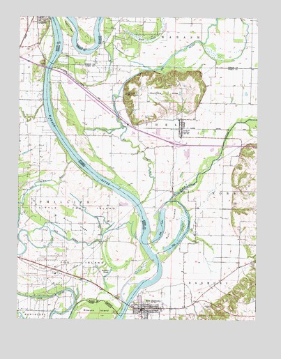
New Harmony, IN USGS Topographic Map
Click on map above to begin viewing in our Map Viewer.

This topographic map contains these locations and features:
Feature Name Type Latitude Longitude GNIS ID View Map
Allen CemeteryCemeteryN38.1734°W87.8875°430084View Map
Big BayouStreamN38.1734°W87.9361°431012View Map
Black RiverStreamN38.1742°W87.9209°431139View Map
Bull IslandIslandN38.1623°W87.9198°405180View Map
Continental CampParkN38.2173°W87.9456°432904View Map
Cox CreekStreamN38.2073°W87.8820°447910View Map
Fox IslandIslandN38.1478°W87.9795°408624View Map
French CreekStreamN38.2139°W87.9873°408740View Map
Goose PondLakeN38.2439°W87.9434°435208View Map
GriffinPopulated PlaceN38.2042°W87.9148°435495View Map
Griffin Bethel Volunteer Fire DepartmentBuildingN38.2072°W87.9162°2625810View Map
Griffin Post OfficePost OfficeN38.2015°W87.9144°2775167View Map
Harmony CreekStreamN38.1350°W87.9381°435751View Map
Kingdom IslandIslandN38.2453°W87.9745°437328View Map
Little Fox IslandIslandN38.1720°W87.9695°412339View Map
Little Fox RiverStreamN38.1912°W87.9723°412340View Map
Lost LakeLakeN38.1640°W87.9252°412659View Map
Mount Pleasant CemeteryCemeteryN38.2081°W87.9342°439643View Map
Mumford HillsRangeN38.2198°W87.9245°439876View Map
Murphy RunStreamN38.1378°W87.9245°439893View Map
New BaltimorePopulated PlaceN38.1773°W87.9175°449048View Map
New HarmonyPopulated PlaceN38.1298°W87.9350°440051View Map
New Harmony BridgeBridgeN38.1314°W87.9425°1823974View Map
New Harmony Fire DepartmentBuildingN38.1304°W87.9189°2626371View Map
New Harmony Town MarshalBuildingN38.1300°W87.9341°2758032View Map
Old ChannelChannelN38.1700°W87.9120°414999View Map
Old Channel Wabash RiverStreamN38.1525°W87.9267°440552View Map
Pelham CemeteryCemeteryN38.1306°W87.8992°440978View Map
Poplar RidgeRidgeN38.1637°W87.9692°416035View Map
Rattling SloughGutN38.1400°W87.9542°416411View Map
Stillwell CemeteryCemeteryN38.1492°W87.8770°444167View Map
Town of GriffinCivilN38.2043°W87.9149°2396978View Map
Town of New HarmonyCivilN38.1290°W87.9308°2396802View Map
Township of BethelCivilN38.2071°W87.9253°453107View Map
Webbs FerryLocaleN38.2292°W87.9859°420685View Map

Note: Coordinates in the location and feature list above are referenced to NAD83 datum.


Copyright (C) 2008-2025 Ryan Niemi / Sunset Dynamics ... All Rights Reserved