TopoQuest Logo
Do you find TopoQuest useful?
Help keep TopoQuest running and adding new maps/features by donating!
Bitcoin:  19c7KJd3qBynnjoSw5npx9KScwjBe4ifkT
Litecoin:  LXs6TkuXGGXo1vDsWCkWVdjQX94eUKd6ui
Home View Maps Find Maps Find Places Resources & Links


Grayville, Illinois Topographic Map

USGS Map Title: Grayville, IL
USGS Map MRC: 38087C8
DRG (GeoTIFF) Download: o38087c8.tif


Neighboring USGS Topographic Map Quads:


  Albion North, IL  
38088D1
 

  Bone Gap, IL  
38087D8
 

  Mount Carmel, IL  
38087D7
 

  Albion South, IL  
38088C1
 

  Grayville, IL  
38087C8
 

  Keensburg, IL  
38087C7
 

  Crossville, IL  
38088B1
 

  New Harmony, IN  
38087B8
 

  Poseyville, IN  
38087B7


Map MRC Location:

N39°
W88°
N39°
W87°
H8 H7 H6 H5 H4 H3 H2 H1
G8 G7 G6 G5 G4 G3 G2 G1
F8 F7 F6 F5 F4 F3 F2 F1
E8 E7 E6 E5 E4 E3 E2 E1
D8 D7 D6 D5 D4 D3 D2 D1
C8 C7 C6 C5 C4 C3 C2 C1
B8 B7 B6 B5 B4 B3 B2 B1
A8 A7 A6 A5 A4 A3 A2 A1
N38°
W88°
N38°
W87°

Grayville, IL USGS 1:24K Topographic Map Preview:
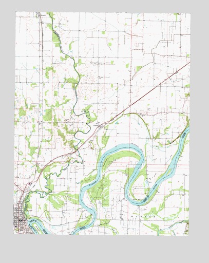
Grayville, IL USGS Topographic Map
Click on map above to begin viewing in our Map Viewer.

This topographic map contains these locations and features:
Feature Name Type Latitude Longitude GNIS ID View Map
Antioch ChurchChurchN38.3178°W87.9098°403555View Map
Antioch Church CemeteryCemeteryN38.3178°W87.9097°2045759View Map
Bonpas CreekStreamN38.2578°W87.9898°404691View Map
Browns Election PrecinctCivilN38.3701°W87.9970°1928453View Map
City of GrayvilleCivilN38.2554°W87.9970°2394970View Map
Compton Election PrecinctCivilN38.3153°W87.9370°1928466View Map
CowlingPopulated PlaceN38.3114°W87.9392°406684View Map
Cowling Post Office (historical)Post OfficeN38.3114°W87.9386°1823657View Map
Denham LeveeLeveeN38.2906°W87.8928°407120View Map
First Baptist ChurchChurchN38.2564°W87.9931°1823957View Map
First Christian ChurchChurchN38.2584°W87.9964°1823959View Map
First Presbyterian ChurchChurchN38.2564°W87.9964°1823962View Map
First United Methodist ChurchChurchN38.2575°W87.9973°1823964View Map
Fortney CemeteryCemeteryN38.3142°W87.9645°408556View Map
Fortney United Methodist ChurchChurchN38.3125°W87.9820°408557View Map
Frazier PrairieAreaN38.3617°W87.9786°1808151View Map
Freidens CemeteryCemeteryN38.3467°W87.9420°2045798View Map
Friedens ChurchChurchN38.3467°W87.9409°408752View Map
GrayvillePopulated PlaceN38.2575°W87.9936°409359View Map
Grayville Ambulance ServiceBuildingN38.2575°W87.9933°2673891View Map
Grayville Police DeptBuildingN38.2575°W87.9934°2758965View Map
Grayville Post OfficePost OfficeN38.2568°W87.9944°2788448View Map
Grayville Public LibraryBuildingN38.2589°W87.9967°1823967View Map
Logansburgh (historical)Populated PlaceN38.3375°W87.8920°1823668View Map
McCleary BluffCliffN38.3045°W87.8836°413197View Map
Mud CreekStreamN38.2825°W87.9778°414170View Map
Peankishaw BendBendN38.3017°W87.9161°415487View Map
Peankishaw BendBendN38.2889°W87.9236°440957View Map
Pearl IslandIslandN38.2909°W87.9350°440961View Map
Saint Johns ChurchChurchN38.3384°W87.9403°417397View Map
Saint Johns Lutheran Church CemeteryCemeteryN38.3384°W87.9403°2045800View Map
Schuh BendBendN38.2700°W87.9156°418117View Map
Seigert Station (historical)LocaleN38.3134°W87.9800°1808173View Map
Township of WabashCivilN38.2667°W87.8752°453964View Map
Upper Hill SchoolSchoolN38.2528°W87.8773°445165View Map
Wheeler CemeteryCemeteryN38.3198°W87.9522°2045801View Map

Note: Coordinates in the location and feature list above are referenced to NAD83 datum.


Copyright (C) 2008-2025 Ryan Niemi / Sunset Dynamics ... All Rights Reserved