TopoQuest Logo
Do you find TopoQuest useful?
Help keep TopoQuest running and adding new maps/features by donating!
Bitcoin:  19c7KJd3qBynnjoSw5npx9KScwjBe4ifkT
Litecoin:  LXs6TkuXGGXo1vDsWCkWVdjQX94eUKd6ui
Home View Maps Find Maps Find Places Resources & Links


Dadeville, Alabama Topographic Map

USGS Map Title: Dadeville, AL
USGS Map MRC: 32085G7
DRG (GeoTIFF) Download: o32085g7.tif


Neighboring USGS Topographic Map Quads:


  Alexander City, AL  
32085H8
 

  Jacksons Gap, AL  
32085H7
 

  Buttston, AL  
32085H6
 

  Our Town, AL  
32085G8
 

  Dadeville, AL  
32085G7
 

  Camp Hill, AL  
32085G6
 

  Red Hill, AL  
32085F8
 

  Ponders, AL  
32085F7
 

  Thornton, AL  
32085F6


Map MRC Location:

N33°
W86°
N33°
W85°
H8 H7 H6 H5 H4 H3 H2 H1
G8 G7 G6 G5 G4 G3 G2 G1
F8 F7 F6 F5 F4 F3 F2 F1
E8 E7 E6 E5 E4 E3 E2 E1
D8 D7 D6 D5 D4 D3 D2 D1
C8 C7 C6 C5 C4 C3 C2 C1
B8 B7 B6 B5 B4 B3 B2 B1
A8 A7 A6 A5 A4 A3 A2 A1
N32°
W86°
N32°
W85°

Dadeville, AL USGS 1:24K Topographic Map Preview:
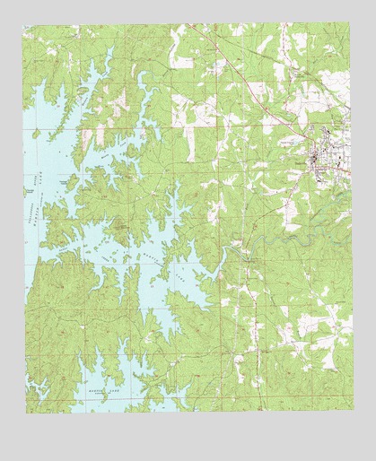
Dadeville, AL USGS Topographic Map
Click on map above to begin viewing in our Map Viewer.

This topographic map contains these locations and features:
Feature Name Type Latitude Longitude GNIS ID View Map
Beaver LakeReservoirN32.7501°W85.8066°130987View Map
Bethel ChurchChurchN32.8279°W85.8208°114057View Map
Buck CreekStreamN32.8032°W85.7963°115125View Map
Chattasofka CreekStreamN32.8062°W85.7669°157912View Map
City of DadevilleCivilN32.8326°W85.7675°2404175View Map
DadevillePopulated PlaceN32.8312°W85.7636°117010View Map
Dadeville Baptist ChurchChurchN32.8293°W85.7650°137392View Map
Dadeville City Police DepartmentBuildingN32.8295°W85.7639°2751848View Map
Dadeville DivisionCivilN32.8436°W85.7618°161623View Map
Dadeville Elementary SchoolSchoolN32.8237°W85.7625°137393View Map
Dadeville Grammar School (historical)SchoolN32.8337°W85.7633°137394View Map
Dadeville High SchoolSchoolN32.8287°W85.7550°137395View Map
Dadeville Post OfficePost OfficeN32.8301°W85.7616°167982View Map
Dadeville Volunteer Fire DepartmentBuildingN32.8334°W85.7650°2691081View Map
Farrow Dennis GraveyardCemeteryN32.8379°W85.8644°137418View Map
First Methodist Church of DadevilleChurchN32.8332°W85.7641°137423View Map
GreenbriarPopulated PlaceN32.8668°W85.8647°137437View Map
Haven Chapel Methodist ChurchChurchN32.8262°W85.7625°137450View Map
Lockhart CemeteryCemeteryN32.7632°W85.7566°121945View Map
Madwin CreekStreamN32.8343°W85.8605°122198View Map
Manoy CreekStreamN32.8268°W85.8538°155145View Map
Mount Olive Baptist ChurchChurchN32.8665°W85.8005°158880View Map
Mount Zion ChurchChurchN32.7690°W85.7966°123472View Map
New Rocky Mount Baptist ChurchChurchN32.8718°W85.8536°152674View Map
Norrell BranchStreamN32.7987°W85.7888°123975View Map
North DadevillePopulated PlaceN32.8576°W85.7727°156802View Map
Oakfuskee (historical)Populated PlaceN32.8168°W85.8736°158381View Map
Old Rocky Mount CemeteryCemeteryN32.8668°W85.8658°137494View Map
Ozella (historical)Populated PlaceN32.8215°W85.8661°137495View Map
Pace's Point Volunteer Fire and RescueBuildingN32.7848°W85.8661°2691418View Map
Pace's Point Volunteer Fire and RescueBuildingN32.7690°W85.8055°2691421View Map
Piney PointPopulated PlaceN32.8440°W85.8597°137501View Map
Pleasant Ridge Baptist ChurchChurchN32.7926°W85.7905°153009View Map
Pleasant Ridge CemeteryCemeteryN32.7923°W85.7908°137504View Map
Pleasant Ridge ChurchChurchN32.7846°W85.7566°125035View Map
Pleasant Valley ChurchChurchN32.8643°W85.8705°153014View Map
Red Ridge CemeteryCemeteryN32.7696°W85.7852°137506View Map
Red Ridge United Methodist ChurchChurchN32.7699°W85.7847°125494View Map
River Bend (historical)Populated PlaceN32.8015°W85.8727°158707View Map
Sandy CreekStreamN32.8026°W85.7958°153325View Map
Sandy Creek ChurchChurchN32.7996°W85.7894°126381View Map
Shady Grove ChurchChurchN32.7732°W85.8197°137525View Map
Shepard GraveyardCemeteryN32.8429°W85.7527°137526View Map
Smith MountainSummitN32.8098°W85.8383°127038View Map
Spain CemeteryCemeteryN32.7654°W85.7952°127157View Map
Still Waters DamDamN32.7501°W85.8066°130988View Map
Stillwaters Volunteer Fire and Rescue Station 1BuildingN32.7675°W85.7954°2691449View Map
Stillwaters Volunteer Fire and Rescue Station 2BuildingN32.7585°W85.7541°2691451View Map
Tallapoosa CountyCivilN32.8624°W85.7975°161587View Map
Tallapoosa County High School (historical)SchoolN32.8343°W85.7597°137541View Map
Tallapoosa Sheriff's Office DadevilleBuildingN32.8087°W85.7719°2751719View Map
Thomas MineMineN32.7849°W85.8458°157748View Map
Union CemeteryCemeteryN32.8610°W85.7975°128267View Map
WDLK-AM (Dadeville)TowerN32.8490°W85.7694°160984View Map
Williams CemeteryCemeteryN32.8265°W85.8338°129006View Map
Younds LandingLocaleN32.8218°W85.8541°157289View Map
Youngs Ferry (historical)CrossingN32.7976°W85.8677°137559View Map
Youngs IslandIslandN32.8246°W85.8558°129317View Map

Note: Coordinates in the location and feature list above are referenced to NAD83 datum.


Copyright (C) 2008-2025 Ryan Niemi / Sunset Dynamics ... All Rights Reserved