TopoQuest Logo
Do you find TopoQuest useful?
Help keep TopoQuest running and adding new maps/features by donating!
Bitcoin:  19c7KJd3qBynnjoSw5npx9KScwjBe4ifkT
Litecoin:  LXs6TkuXGGXo1vDsWCkWVdjQX94eUKd6ui
Home View Maps Find Maps Find Places Resources & Links


Ponders, Alabama Topographic Map

USGS Map Title: Ponders, AL
USGS Map MRC: 32085F7
DRG (GeoTIFF) Download: o32085f7.tif


Neighboring USGS Topographic Map Quads:


  Our Town, AL  
32085G8
 

  Dadeville, AL  
32085G7
 

  Camp Hill, AL  
32085G6
 

  Red Hill, AL  
32085F8
 

  Ponders, AL  
32085F7
 

  Thornton, AL  
32085F6
 

  Tallassee, AL  
32085E8
 

  Carrville, AL  
32085E7
 

  Notasulga, AL  
32085E6


Map MRC Location:

N33°
W86°
N33°
W85°
H8 H7 H6 H5 H4 H3 H2 H1
G8 G7 G6 G5 G4 G3 G2 G1
F8 F7 F6 F5 F4 F3 F2 F1
E8 E7 E6 E5 E4 E3 E2 E1
D8 D7 D6 D5 D4 D3 D2 D1
C8 C7 C6 C5 C4 C3 C2 C1
B8 B7 B6 B5 B4 B3 B2 B1
A8 A7 A6 A5 A4 A3 A2 A1
N32°
W86°
N32°
W85°

Ponders, AL USGS 1:24K Topographic Map Preview:
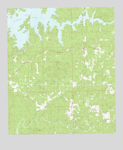
Ponders, AL USGS Topographic Map
Click on map above to begin viewing in our Map Viewer.

This topographic map contains these locations and features:
Feature Name Type Latitude Longitude GNIS ID View Map
Bama ParkPopulated PlaceN32.7162°W85.8519°137369View Map
BarnesvillePopulated PlaceN32.7057°W85.8158°156027View Map
Beulah Baptist ChurchChurchN32.6621°W85.8555°114184View Map
Beulah CemeteryCemeteryN32.6621°W85.8561°137372View Map
Blue CreekPopulated PlaceN32.7362°W85.7880°137374View Map
Blue CreekStreamN32.7382°W85.8250°114536View Map
Blue Creek MarinaLocaleN32.7346°W85.7869°137375View Map
Buck CreekStreamN32.6401°W85.8444°115112View Map
Copper CreekStreamN32.7104°W85.8577°116611View Map
Erie (historical)Populated PlaceN32.7154°W85.8041°138975View Map
Guthrie CemeteryCemeteryN32.6637°W85.8702°137438View Map
Harper Hill CemeteryCemeteryN32.6707°W85.8380°137449View Map
Harper Hill ChurchChurchN32.6704°W85.8380°119770View Map
John Johnston CemeteryCemeteryN32.6853°W85.8472°2611113View Map
Ledbetter CreekStreamN32.6326°W85.7980°121456View Map
Maxwell-Gunter Recreation AreaParkN32.7007°W85.7602°137472View Map
Mitchell CreekStreamN32.6282°W85.7844°152351View Map
New Prospect ChurchChurchN32.6776°W85.8191°123886View Map
Old Sharon Primitive Baptist CemeteryCemeteryN32.6411°W85.7966°2611114View Map
Pleasant Valley ChurchChurchN32.6737°W85.7766°125047View Map
Pleasant Valley School (historical)SchoolN32.6735°W85.7755°157699View Map
PondersPopulated PlaceN32.7104°W85.7741°125125View Map
SardisPopulated PlaceN32.7040°W85.7580°137522View Map
Sardis CemeteryCemeteryN32.7046°W85.7588°137523View Map
Sardis Methodist ChurchChurchN32.7040°W85.7586°153336View Map
Sougahatchee ChurchChurchN32.6415°W85.7966°127108View Map
Sougahatchee Lookout TowerTowerN32.6290°W85.8408°164421View Map
Still WatersPopulated PlaceN32.7451°W85.8075°137533View Map
Still Waters MarinaLocaleN32.7365°W85.8230°137534View Map
UnionPopulated PlaceN32.6987°W85.8472°128261View Map
Union AcademySchoolN32.6960°W85.8550°169333View Map
Union CemeteryCemeteryN32.6979°W85.8525°137543View Map
Union ChurchChurchN32.6968°W85.8680°137544View Map
Union Volunteer Fire and Rescue DepartmentBuildingN32.7027°W85.8412°2691284View Map
Union Volunteer Fire and Rescue DepartmentBuildingN32.6637°W85.8172°2691588View Map
Walnut HillPopulated PlaceN32.7101°W85.7855°157213View Map

Note: Coordinates in the location and feature list above are referenced to NAD83 datum.


Copyright (C) 2008-2024 Ryan Niemi / Sunset Dynamics ... All Rights Reserved