TopoQuest Logo
Do you find TopoQuest useful?
Help keep TopoQuest running and adding new maps/features by donating!
Bitcoin:  19c7KJd3qBynnjoSw5npx9KScwjBe4ifkT
Litecoin:  LXs6TkuXGGXo1vDsWCkWVdjQX94eUKd6ui
Home View Maps Find Maps Find Places Resources & Links


Buttston, Alabama Topographic Map

USGS Map Title: Buttston, AL
USGS Map MRC: 32085H6
DRG (GeoTIFF) Download: o32085h6.tif


Neighboring USGS Topographic Map Quads:


  New Site, AL  
33085A7
 

  Daviston, AL  
33085A6
 

  Wadley South, AL  
33085A5
 

  Jacksons Gap, AL  
32085H7
 

  Buttston, AL  
32085H6
 

  Dudleyville, AL  
32085H5
 

  Dadeville, AL  
32085G7
 

  Camp Hill, AL  
32085G6
 

  Camp Hill SE, AL  
32085G5


Map MRC Location:

N33°
W86°
N33°
W85°
H8 H7 H6 H5 H4 H3 H2 H1
G8 G7 G6 G5 G4 G3 G2 G1
F8 F7 F6 F5 F4 F3 F2 F1
E8 E7 E6 E5 E4 E3 E2 E1
D8 D7 D6 D5 D4 D3 D2 D1
C8 C7 C6 C5 C4 C3 C2 C1
B8 B7 B6 B5 B4 B3 B2 B1
A8 A7 A6 A5 A4 A3 A2 A1
N32°
W86°
N32°
W85°

Buttston, AL USGS 1:24K Topographic Map Preview:
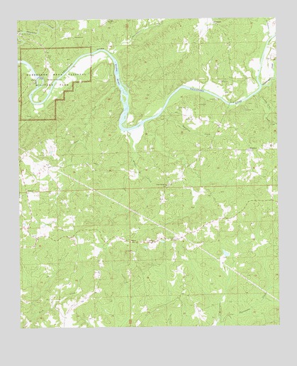
Buttston, AL USGS Topographic Map
Click on map above to begin viewing in our Map Viewer.

This topographic map contains these locations and features:
Feature Name Type Latitude Longitude GNIS ID View Map
Abernathy ProspectsMineN32.9112°W85.6813°157683View Map
Berry MineMineN32.9035°W85.7100°157686View Map
Bethlehem ChurchChurchN32.9932°W85.7227°114130View Map
ButtstonPopulated PlaceN32.9465°W85.6383°156141View Map
Buttston Baptist ChurchChurchN32.9465°W85.6391°137429View Map
Buttston CemeteryCemeteryN32.9465°W85.6397°137376View Map
Buttston School (historical)SchoolN32.9473°W85.6388°158681View Map
Buttston Volunteer Fire DepartmentBuildingN32.9562°W85.6515°2691609View Map
Carlton MineMineN32.9646°W85.6313°157687View Map
Chatahospee CreekStreamN32.9723°W85.6322°151729View Map
Cholocco Litabixee (historical)Populated PlaceN32.9779°W85.7333°137382View Map
County Line CreekStreamN32.9693°W85.6350°163930View Map
Eagle CreekStreamN32.9729°W85.7025°117719View Map
EastonPopulated PlaceN32.9093°W85.6966°156294View Map
Elder ChurchChurchN32.9415°W85.7125°117913View Map
Elder School (historical)SchoolN32.9454°W85.7094°157690View Map
EvergladePopulated PlaceN32.9979°W85.6552°156326View Map
Everglade School (historical)SchoolN32.9979°W85.6547°159035View Map
Galloway CreekStreamN32.9921°W85.6277°151787View Map
Germany Family CemeteryCemeteryN32.9760°W85.6461°137432View Map
Germany Ferry (historical)CrossingN32.9654°W85.6469°158993View Map
Germanys Ferry BridgeBridgeN32.9654°W85.6477°137433View Map
Gillam CemeteryCemeteryN32.8835°W85.6730°137434View Map
Griffin Ferry (historical)CrossingN32.9723°W85.7000°137457View Map
Griffin ShoalsBarN32.9773°W85.7027°119411View Map
Hamlet (historical)Populated PlaceN32.9948°W85.7483°158994View Map
Hamlet Mill BridgeBridgeN32.9948°W85.7500°119646View Map
Horseshoe BendBendN32.9676°W85.7416°158696View Map
Horseshoe Bend National Military ParkParkN32.9767°W85.7341°149966View Map
Howard MineMineN32.9115°W85.6725°157691View Map
Kidd MineMineN32.9068°W85.6900°157692View Map
Lake HowardReservoirN32.9045°W85.6505°131089View Map
Lebanon CemeteryCemeteryN32.9107°W85.6755°121450View Map
Lebanon ChurchChurchN32.9096°W85.6855°121452View Map
Matilda (historical)Populated PlaceN32.9682°W85.6847°137471View Map
Matilda Ferry (historical)CrossingN32.9612°W85.6833°158699View Map
Mica Hill MineMineN32.9037°W85.6944°157694View Map
Miller CreekStreamN32.9548°W85.6980°122828View Map
Millers BridgeBridgeN32.9768°W85.7405°158870View Map
Millers Ferry (historical)CrossingN32.9773°W85.7430°137476View Map
Niuyaka (historical)Populated PlaceN32.9640°W85.7041°158148View Map
Oakfuskee Council House (historical)LocaleN32.9701°W85.6533°137490View Map
Oakfuskudshi (historical)Populated PlaceN32.9696°W85.6458°158382View Map
Poplar Springs ChurchChurchN32.9323°W85.6794°125171View Map
Popular Springs School (historical)SchoolN32.9321°W85.6786°158706View Map
Punkin Hill CemeteryCemeteryN32.9282°W85.6572°137505View Map
Saunders ProspectMineN32.9285°W85.6405°157700View Map
Schryer DamDamN32.9051°W85.6500°131090View Map
SessionsPopulated PlaceN32.9301°W85.7466°126554View Map
Soapstone CreekStreamN32.9610°W85.6825°127088View Map
Sweetwater CreekStreamN32.9868°W85.7066°127595View Map
Swindall DamDamN32.9451°W85.7366°131107View Map
Swindall LakeReservoirN32.9451°W85.7366°131106View Map
Vines ProspectMineN32.9207°W85.6550°157702View Map
Washburne ProspectMineN32.9107°W85.7250°163305View Map
Zion Hill ChurchChurchN32.9998°W85.7063°150027View Map
Zions Hill School (historical)SchoolN32.9998°W85.7055°157703View Map

Note: Coordinates in the location and feature list above are referenced to NAD83 datum.


Copyright (C) 2008-2024 Ryan Niemi / Sunset Dynamics ... All Rights Reserved