TopoQuest Logo
Do you find TopoQuest useful?
Help keep TopoQuest running and adding new maps/features by donating!
Bitcoin:  19c7KJd3qBynnjoSw5npx9KScwjBe4ifkT
Litecoin:  LXs6TkuXGGXo1vDsWCkWVdjQX94eUKd6ui
Home View Maps Find Maps Find Places Resources & Links


Everton, Missouri Topographic Map

USGS Map Title: Everton, MO
USGS Map MRC: 37093C6
DRG (GeoTIFF) Download: o37093c6.tif


Neighboring USGS Topographic Map Quads:


  Greenfield, MO  
37093D7
 

  Dadeville, MO  
37093D6
 

  Walnut Grove, MO  
37093D5
 

  South Greenfield, MO  
37093C7
 

  Everton, MO  
37093C6
 

  Ash Grove, MO  
37093C5
 

  Miller, MO  
37093B7
 

  Halltown, MO  
37093B6
 

  Halltown NE, MO  
37093B5


Map MRC Location:

N38°
W94°
N38°
W93°
H8 H7 H6 H5 H4 H3 H2 H1
G8 G7 G6 G5 G4 G3 G2 G1
F8 F7 F6 F5 F4 F3 F2 F1
E8 E7 E6 E5 E4 E3 E2 E1
D8 D7 D6 D5 D4 D3 D2 D1
C8 C7 C6 C5 C4 C3 C2 C1
B8 B7 B6 B5 B4 B3 B2 B1
A8 A7 A6 A5 A4 A3 A2 A1
N37°
W94°
N37°
W93°

Everton, MO USGS 1:24K Topographic Map Preview:
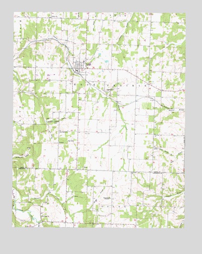
Everton, MO USGS Topographic Map
Click on map above to begin viewing in our Map Viewer.

This topographic map contains these locations and features:
Feature Name Type Latitude Longitude GNIS ID View Map
City of EvertonCivilN37.3429°W93.7024°2394715View Map
East LimekilnLocaleN37.3545°W93.7113°740369View Map
Ellingsen FieldAirportN37.3569°W93.6631°2679412View Map
Emmett (historical)Populated PlaceN37.3262°W93.6533°740058View Map
EvertonPopulated PlaceN37.3425°W93.7024°717698View Map
Everton City Fire DepartmentBuildingN37.3408°W93.7040°2621686View Map
Everton Elementary SchoolSchoolN37.3462°W93.6982°2710685View Map
Everton High SchoolSchoolN37.3466°W93.6990°2710683View Map
Everton Middle SchoolSchoolN37.3462°W93.6989°2710684View Map
Everton Post OfficePost OfficeN37.3408°W93.7036°2783088View Map
Everton Rural Fire DepartmentBuildingN37.3408°W93.7038°2620286View Map
Grove School (historical)SchoolN37.3275°W93.6744°746307View Map
Henry School (historical)SchoolN37.3495°W93.6510°746305View Map
Hood CemeteryCemeteryN37.2539°W93.7444°719773View Map
Hopewell ChurchChurchN37.2823°W93.6646°719800View Map
Hopewell School (historical)SchoolN37.2670°W93.6794°719811View Map
Independence School (historical)SchoolN37.2592°W93.6321°746370View Map
Johnson LakeReservoirN37.3114°W93.7216°720377View Map
KXBR-FM (Greenfield)TowerN37.3720°W93.7094°759057View Map
Liberty ChurchChurchN37.3720°W93.7224°720973View Map
Mill BranchStreamN37.2528°W93.7308°722322View Map
Morrison - Richardson CemeteryCemeteryN37.2570°W93.6874°725256View Map
New Home ChurchChurchN37.2562°W93.7297°723221View Map
Ray SpringSpringN37.3004°W93.7102°725131View Map
Ray Spring BranchStreamN37.3109°W93.7260°725132View Map
Ray Spring ChurchChurchN37.3053°W93.7166°725133View Map
Ray Springs School (historical)SchoolN37.3062°W93.7127°746304View Map
Scott School (historical)SchoolN37.3053°W93.6630°746308View Map
Scott SpringSpringN37.2964°W93.6452°726157View Map
Scott Spring BranchStreamN37.2923°W93.6313°726159View Map
Silver Star School (historical)SchoolN37.3312°W93.6263°746306View Map
Sinking Creek ChurchChurchN37.3289°W93.6819°726486View Map
Smyrna School (historical)SchoolN37.2643°W93.7282°746369View Map
Township of Rock PrairieCivilN37.3268°W93.6795°766559View Map
Wright BranchStreamN37.2606°W93.6963°729154View Map

Note: Coordinates in the location and feature list above are referenced to NAD83 datum.


Copyright (C) 2008-2024 Ryan Niemi / Sunset Dynamics ... All Rights Reserved