TopoQuest Logo
Do you find TopoQuest useful?
Help keep TopoQuest running and adding new maps/features by donating!
Bitcoin:  19c7KJd3qBynnjoSw5npx9KScwjBe4ifkT
Litecoin:  LXs6TkuXGGXo1vDsWCkWVdjQX94eUKd6ui
Home View Maps Find Maps Find Places Resources & Links


Daleville, Alabama Topographic Map

USGS Map Title: Daleville, AL
USGS Map MRC: 31085C6
DRG (GeoTIFF) Download: o31085c6.tif


Neighboring USGS Topographic Map Quads:


  Enterprise NE, AL  
31085D7
 

  Ozark, AL  
31085D6
 

  Ewell, AL  
31085D5
 

  Enterprise, AL  
31085C7
 

  Daleville, AL  
31085C6
 

  Pinckard, AL  
31085C5
 

  Bellwood, AL  
31085B7
 

  Clayhatchee, AL  
31085B6
 

  Malvern, AL  
31085B5


Map MRC Location:

N32°
W86°
N32°
W85°
H8 H7 H6 H5 H4 H3 H2 H1
G8 G7 G6 G5 G4 G3 G2 G1
F8 F7 F6 F5 F4 F3 F2 F1
E8 E7 E6 E5 E4 E3 E2 E1
D8 D7 D6 D5 D4 D3 D2 D1
C8 C7 C6 C5 C4 C3 C2 C1
B8 B7 B6 B5 B4 B3 B2 B1
A8 A7 A6 A5 A4 A3 A2 A1
N31°
W86°
N31°
W85°

Daleville, AL USGS 1:24K Topographic Map Preview:
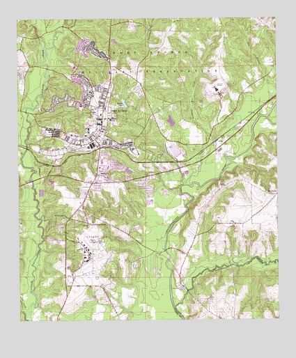
Daleville, AL USGS Topographic Map
Click on map above to begin viewing in our Map Viewer.

This topographic map contains these locations and features:
Feature Name Type Latitude Longitude GNIS ID View Map
Allen HeightsPopulated PlaceN31.3632°W85.7138°155785View Map
Beaver LakeReservoirN31.3403°W85.6986°113742View Map
Bethel Baptist ChurchChurchN31.2902°W85.6458°114034View Map
Bethel CemeteryCemeteryN31.2899°W85.6449°1729942View Map
Bethel School (historical)SchoolN31.2905°W85.6458°133457View Map
Bowden TerracePopulated PlaceN31.3488°W85.7180°155786View Map
Brooking Mill CreekStreamN31.3063°W85.6705°114953View Map
Burnt Mill BridgeBridgeN31.2621°W85.6688°133464View Map
Byrds BranchStreamN31.3318°W85.7438°133466View Map
Cairns Army Airfield (Fort Rucker)AirportN31.2766°W85.7148°2676348View Map
Chapel of the FlagsChurchN31.3441°W85.7094°157741View Map
Choctawhatchee WellsWellN31.2638°W85.6719°116085View Map
City of DalevilleCivilN31.2914°W85.7114°2404178View Map
Cowpen CreekStreamN31.3188°W85.7480°116770View Map
DalevillePopulated PlaceN31.3102°W85.7130°117016View Map
Daleville ChurchChurchN31.2902°W85.7169°117017View Map
Daleville Department of Public Safety Fire StationBuildingN31.2982°W85.7204°2330960View Map
Daleville DivisionCivilN31.2675°W85.7393°165739View Map
Daleville High SchoolSchoolN31.3157°W85.7097°133478View Map
Daleville Memorial GardensCemeteryN31.2863°W85.6985°133479View Map
Daleville Police DepartmentBuildingN31.2982°W85.7205°2751929View Map
Daleville Post OfficePost OfficeN31.2984°W85.7223°166982View Map
Daleville Station (historical)LocaleN31.3218°W85.7110°133480View Map
Directorate of Public Safety Fire and Emergency ServicesBuildingN31.3304°W85.7091°2691514View Map
Fifth Avenue ChapelChurchN31.3266°W85.7152°157742View Map
First Baptist Church of KellyChurchN31.3274°W85.6438°155806View Map
Five PointsPopulated PlaceN31.3018°W85.6252°118337View Map
Fort Rucker Census Designated PlaceCensusN31.3428°W85.7154°2402503View Map
Fort Rucker DamDamN31.3302°W85.6749°129769View Map
Fort Rucker Elementary SchoolSchoolN31.3391°W85.7194°157743View Map
Fort Rucker Post OfficePost OfficeN31.3398°W85.7110°166983View Map
Fort Rucker Primary SchoolSchoolN31.3549°W85.7227°157744View Map
Four Mile CreekStreamN31.3716°W85.7277°133491View Map
Golden BridgeBridgeN31.2724°W85.6477°133493View Map
Hanchey AHP AirportAirportN31.3502°W85.6666°129396View Map
Harrand CreekStreamN31.3388°W85.7455°119778View Map
Hutton Plaza Shopping CenterLocaleN31.3366°W85.7130°157745View Map
KellyPopulated PlaceN31.3238°W85.6552°156547View Map
Knox HeliportAirportN31.3204°W85.6738°1699902View Map
Line CreekStreamN31.2535°W85.7474°121671View Map
Little Choctawhatchee RiverStreamN31.2555°W85.6755°121736View Map
Lowe AHP AirportAirportN31.3502°W85.7499°129397View Map
Lower Iron BridgeBridgeN31.2791°W85.6791°133504View Map
Marchman Church (historical)ChurchN31.3438°W85.6774°133508View Map
Moores ChapelChurchN31.3057°W85.6508°149981View Map
Munson HeightsPopulated PlaceN31.3418°W85.7283°155789View Map
New Sumnerhill ChurchChurchN31.2932°W85.7269°149995View Map
Peters BranchStreamN31.2630°W85.6772°133527View Map
Piney Grove Church (historical)ChurchN31.3485°W85.6485°133529View Map
Rocky Hill Church (historical)ChurchN31.3693°W85.6502°163877View Map
Rocky Hill School (historical)SchoolN31.3691°W85.6505°133542View Map
Saint Marys School (historical)SchoolN31.2924°W85.7260°157660View Map
Shiloh Church (historical)ChurchN31.3404°W85.6788°133549View Map
Silver Wings Golf CourseLocaleN31.3535°W85.6982°2579636View Map
Snell BridgeBridgeN31.2855°W85.7385°133550View Map
Snell Mill BranchStreamN31.2818°W85.7408°133551View Map
Steep Head CreekStreamN31.3632°W85.7366°153564View Map
Summer Hill Church (historical)ChurchN31.3493°W85.7044°133557View Map
United States Army Aeromedical Center Lyster Army HospitalHospitalN31.3274°W85.7236°157746View Map
United States Army Aviation MuseumBuildingN31.3241°W85.7132°2580117View Map

Note: Coordinates in the location and feature list above are referenced to NAD83 datum.


Copyright (C) 2008-2025 Ryan Niemi / Sunset Dynamics ... All Rights Reserved