TopoQuest Logo
Do you find TopoQuest useful?
Help keep TopoQuest running and adding new maps/features by donating!
Bitcoin:  19c7KJd3qBynnjoSw5npx9KScwjBe4ifkT
Litecoin:  LXs6TkuXGGXo1vDsWCkWVdjQX94eUKd6ui
Home View Maps Find Maps Find Places Resources & Links


Clayhatchee, Alabama Topographic Map

USGS Map Title: Clayhatchee, AL
USGS Map MRC: 31085B6
DRG (GeoTIFF) Download: o31085b6.tif


Neighboring USGS Topographic Map Quads:


  Enterprise, AL  
31085C7
 

  Daleville, AL  
31085C6
 

  Pinckard, AL  
31085C5
 

  Bellwood, AL  
31085B7
 

  Clayhatchee, AL  
31085B6
 

  Malvern, AL  
31085B5
 

  Geneva East, AL  
31085A7
 

  Hartford, AL  
31085A6
 

  Slocomb, AL  
31085A5


Map MRC Location:

N32°
W86°
N32°
W85°
H8 H7 H6 H5 H4 H3 H2 H1
G8 G7 G6 G5 G4 G3 G2 G1
F8 F7 F6 F5 F4 F3 F2 F1
E8 E7 E6 E5 E4 E3 E2 E1
D8 D7 D6 D5 D4 D3 D2 D1
C8 C7 C6 C5 C4 C3 C2 C1
B8 B7 B6 B5 B4 B3 B2 B1
A8 A7 A6 A5 A4 A3 A2 A1
N31°
W86°
N31°
W85°

Clayhatchee, AL USGS 1:24K Topographic Map Preview:
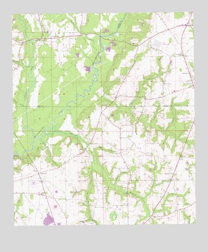
Clayhatchee, AL USGS Topographic Map
Click on map above to begin viewing in our Map Viewer.

This topographic map contains these locations and features:
Feature Name Type Latitude Longitude GNIS ID View Map
Antioch ChurchChurchN31.1513°W85.7288°113120View Map
Backems CrossroadsPopulated PlaceN31.2418°W85.6305°138625View Map
Bald HillPopulated PlaceN31.1638°W85.6355°113396View Map
Ball Hill ChurchChurchN31.1660°W85.6349°132089View Map
Bethel Baptist ChurchChurchN31.1674°W85.6763°114030View Map
Biffords BranchStreamN31.2441°W85.6755°132227View Map
Brackin Mill CreekStreamN31.2199°W85.7374°114801View Map
Caney CreekStreamN31.1324°W85.6566°115572View Map
Christian Home ChurchChurchN31.2396°W85.6422°163804View Map
Claybank CreekStreamN31.1774°W85.7347°116203View Map
ClayhatcheePopulated PlaceN31.2357°W85.7227°116204View Map
Clayhatchee (historical)LocaleN31.2043°W85.6888°138626View Map
Clayhatchee ChurchChurchN31.2435°W85.7022°133472View Map
Clayhatchee Police DepartmentBuildingN31.2358°W85.7163°2752011View Map
Clayhatchee QuarryMineN31.2181°W85.7025°2633167View Map
Clayhatchee Volunteer Fire DepartmentBuildingN31.2358°W85.7163°2691130View Map
Corbin School (historical)SchoolN31.1877°W85.6385°132114View Map
County Line ChurchChurchN31.1993°W85.6577°116719View Map
Cox Mill CreekStreamN31.1638°W85.6941°116791View Map
Dean Mill (historical)LocaleN31.1257°W85.6288°132117View Map
Dowling BranchStreamN31.1293°W85.6966°117446View Map
Goodwater ChurchChurchN31.2141°W85.6269°119150View Map
Gospel Hill ChurchChurchN31.1516°W85.6944°132131View Map
Ham BranchStreamN31.1293°W85.6966°119610View Map
High BluffPopulated PlaceN31.1566°W85.7313°120053View Map
High Bluff SchoolSchoolN31.1441°W85.7444°132137View Map
Hinson Mill (historical)LocaleN31.1293°W85.6560°132140View Map
House of Prayer ChurchChurchN31.1516°W85.6547°132143View Map
Hurricane CreekStreamN31.1791°W85.7266°151835View Map
Kinsanl School (historical)SchoolN31.1666°W85.6763°132147View Map
Macedonia CemeteryCemeteryN31.1366°W85.6758°122142View Map
Macedonia Church (historical)ChurchN31.2293°W85.6555°132329View Map
Macedonia Church (historical)ChurchN31.1374°W85.6766°132151View Map
Mount Gilead CemeteryCemeteryN31.1966°W85.6860°138641View Map
Mount Gilead Primitive Baptist ChurchChurchN31.1963°W85.6847°123190View Map
Panther StadiumParkN31.2247°W85.6339°2360229View Map
Pates CreekStreamN31.2046°W85.6963°124477View Map
Pates Landing (historical)LocaleN31.2049°W85.6963°138642View Map
Peacock BranchStreamN31.1491°W85.6810°124545View Map
Poley BranchStreamN31.1482°W85.6535°125098View Map
Posey HollowValleyN31.1705°W85.6949°125188View Map
Providence Missionary Baptist ChurchChurchN31.2352°W85.7305°153076View Map
Sandy BranchStreamN31.1405°W85.6622°126365View Map
Sconyers BranchStreamN31.2210°W85.6924°126471View Map
Sevall School (historical)SchoolN31.1371°W85.6980°132186View Map
Shiloh CemeteryCemeteryN31.2393°W85.7283°126716View Map
Shiloh ChurchChurchN31.2438°W85.7299°133548View Map
Spann BranchStreamN31.1768°W85.7302°127163View Map
Tabernacle ChurchChurchN31.1552°W85.6399°127622View Map
Ted Sketo DamDamN31.1585°W85.7499°129674View Map
Ted Sketo LakeReservoirN31.1585°W85.7499°129673View Map
Thomley Mill CreekStreamN31.1930°W85.6702°127883View Map
Tindell School (historical)SchoolN31.1993°W85.6580°138647View Map
Town of ClayhatcheeCivilN31.2388°W85.7215°2406273View Map
Turners Ferry (historical)CrossingN31.1938°W85.7124°132193View Map
Walden BranchStreamN31.1938°W85.7408°128502View Map
Whaley CemeteryCemeteryN31.1471°W85.6716°128818View Map
Whaley ChapelChurchN31.1549°W85.6666°132204View Map
Wicksburg High SchoolSchoolN31.2257°W85.6333°165586View Map
Wilson School (historical)SchoolN31.2302°W85.6649°132434View Map

Note: Coordinates in the location and feature list above are referenced to NAD83 datum.


Copyright (C) 2008-2024 Ryan Niemi / Sunset Dynamics ... All Rights Reserved