TopoQuest Logo
Do you find TopoQuest useful?
Help keep TopoQuest running and adding new maps/features by donating!
Bitcoin:  19c7KJd3qBynnjoSw5npx9KScwjBe4ifkT
Litecoin:  LXs6TkuXGGXo1vDsWCkWVdjQX94eUKd6ui
Home View Maps Find Maps Find Places Resources & Links


Reward, Pennsylvania Topographic Map

USGS Map Title: Reward, PA
USGS Map MRC: 40077E1
DRG (GeoTIFF) Download: o40077e1.tif


Neighboring USGS Topographic Map Quads:


  Beaver Springs, PA  
40077F2
 

  Richfield, PA  
40077F1
 

  Dalmatia, PA  
40076F8
 

  Millerstown, PA  
40077E2
 

  Reward, PA  
40077E1
 

  Millersburg, PA  
40076E8
 

  Newport, PA  
40077D2
 

  Duncannon, PA  
40077D1
 

  Halifax, PA  
40076D8


Map MRC Location:

N41°
W78°
N41°
W77°
H8 H7 H6 H5 H4 H3 H2 H1
G8 G7 G6 G5 G4 G3 G2 G1
F8 F7 F6 F5 F4 F3 F2 F1
E8 E7 E6 E5 E4 E3 E2 E1
D8 D7 D6 D5 D4 D3 D2 D1
C8 C7 C6 C5 C4 C3 C2 C1
B8 B7 B6 B5 B4 B3 B2 B1
A8 A7 A6 A5 A4 A3 A2 A1
N40°
W78°
N40°
W77°

Reward, PA USGS 1:24K Topographic Map Preview:
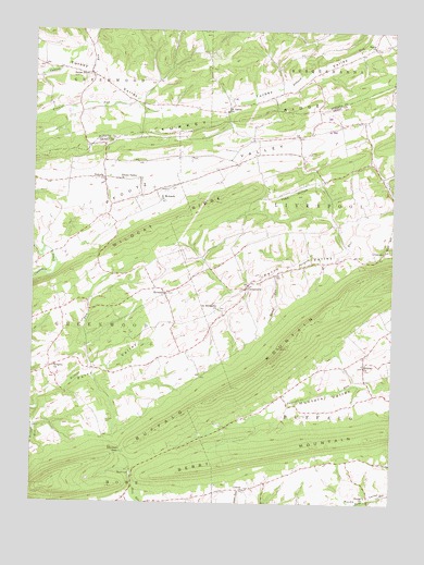
Reward, PA USGS Topographic Map
Click on map above to begin viewing in our Map Viewer.

This topographic map contains these locations and features:
Feature Name Type Latitude Longitude GNIS ID View Map
Barger RunStreamN40.5679°W77.0155°1197126View Map
Berry MountainSummitN40.5101°W77.0591°1169313View Map
Bucks ChurchChurchN40.5018°W77.0080°1170574View Map
Buffalo MountainSummitN40.5412°W77.0361°1170609View Map
Center ChurchChurchN40.5037°W77.0497°1171431View Map
CentervillePopulated PlaceN40.5570°W77.0500°1171472View Map
Messiah ChurchChurchN40.5365°W77.0091°1180966View Map
Mitchell CemeteryCemeteryN40.5215°W77.0989°1181366View Map
Mitchell GapGapN40.5131°W77.0930°1181371View Map
NekodaPopulated PlaceN40.5859°W77.0997°1182236View Map
Newport ReservoirReservoirN40.5159°W77.0900°1197125View Map
Owl Hollow SchoolSchoolN40.5206°W77.1178°1197123View Map
Perry ValleyValleyN40.5672°W77.0155°1183604View Map
Pfoutz ValleyPopulated PlaceN40.5959°W77.0464°1197124View Map
Pfoutz Valley ChurchChurchN40.5856°W77.0944°1183650View Map
RewardPopulated PlaceN40.5554°W77.0783°1184957View Map
Saint James ChurchChurchN40.6037°W77.0569°1186020View Map
Saint Matthews ChurchChurchN40.5515°W77.0594°1186455View Map
Saint Michaels ChurchChurchN40.5795°W77.0791°1186490View Map
Salem ChurchChurchN40.6204°W77.0064°1186835View Map
Seven StarsPopulated PlaceN40.6134°W77.1050°1187267View Map
Spruce RunStreamN40.5609°W77.0400°1188345View Map
Toad HollowValleyN40.5849°W77.0262°1189604View Map
Township of BuffaloCivilN40.5148°W77.0176°1216936View Map
Township of GreenwoodCivilN40.6188°W77.1155°1216582View Map
Township of GreenwoodCivilN40.5550°W77.1124°1216939View Map
Township of LiverpoolCivilN40.5829°W77.0200°1216943View Map
Turkey RidgeRidgeN40.5984°W77.0700°1199704View Map
Turkey ValleyFlatN40.6109°W77.0969°1189952View Map
Wildcat RidgeRidgeN40.5798°W77.0605°1190959View Map
Wrights ChurchChurchN40.5359°W77.1172°1191809View Map

Note: Coordinates in the location and feature list above are referenced to NAD83 datum.


Copyright (C) 2008-2024 Ryan Niemi / Sunset Dynamics ... All Rights Reserved